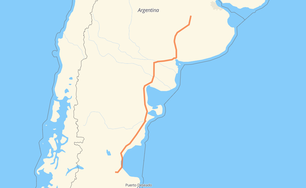
Distance between 9 de Julio and Teresita
The distance from 9 de Julio to Teresita is 1,684 kilometers by road. Road takes approximately 19 hours and 27 minutes and goes through Bahía Blanca, Comodoro Rivadavia, Caleta Olivia, Pigüé, Villa Bordeu, Río Colorado and El Empalme.
| Shortest distance by air | 1,398 km ✈️ |
| Car route length | 1,684 km 🚗 |
| Driving time | 19 h 27 min |
| Fuel amount | 134.7 L |
| Fuel cost | 242.5 AUD |
| Point | Distance | Time | Fuel | |
| 9 de Julio | 0 km | 00 min | 0.0 L | |
|
RP65 324 km, 3 h 41 min
|
||||
| Pigüé | 324 km | 3 h 41 min | 24.1 L | |
|
RN33 92 km, 1 h 06 min
|
||||
| Villa Bordeu | 416 km | 4 h 47 min | 30.6 L | |
|
RN33 RN22 195 km, 2 h 15 min
|
||||
| Río Colorado | 611 km | 7 h 02 min | 48.8 L | |
|
RN22 RN251 235 km, 2 h 38 min
|
||||
| El Empalme | 846 km | 9 h 41 min | 67.4 L | |
|
RN3 121 km, 1 h 21 min
|
||||
| Sierra Grande | 967 km | 11 h 02 min | 77.3 L | |
|
RN3 121 km, 1 h 21 min
|
||||
| El Doradillo | 1,088 km | 12 h 24 min | 86.8 L | |
|
RN3 76 km, 51 min
|
||||
| Los Teros | 1,164 km | 13 h 15 min | 93.0 L | |
|
RN3 370 km, 4 h 11 min
|
||||
| Comodoro Rivadavia | 1,534 km | 17 h 27 min | 122.7 L | |
|
RN3 150 km, 2 h 00 min
|
||||
| Teresita | 1,684 km | 19 h 27 min | 134.4 L | |
Frequently Asked Questions
How much does it cost to drive from 9 de Julio to Teresita?
Fuel cost: 242.5 AUD
This fuel cost is calculated as: (Route length 1,684 km / 100 km) * (Fuel consumption 8 L/100 km) * (Fuel price 1.8 AUD / L)
You can adjust fuel consumption and fuel price here.
How long is a car ride from 9 de Julio to Teresita?
Driving time: 19 h 27 min
This time is calculated for driving at the maximum permitted speed, taking into account traffic rules restrictions.
- 1,492 km with a maximum speed 90 km/h = 16 h 34 min
- 128 km with a maximum speed 80 km/h = 1 h 35 min
- 7 km with a maximum speed 65 km/h = 6 min
- 38 km with a maximum speed 60 km/h = 37 min
- 7 km with a maximum speed 50 km/h = 7 min
- 7 km with a maximum speed 40 km/h = 10 min
- 5 km with a maximum speed 20 km/h = 13 min
The calculated driving time does not take into account intermediate stops and traffic jams.
How far is 9 de Julio to Teresita by land?
The distance between 9 de Julio and Teresita is 1,684 km by road.
Precise satellite coordinates of highways were used for this calculation. The start and finish points are the centers of 9 de Julio and Teresita respectively.
How far is 9 de Julio to Teresita by plane?
The shortest distance (air line, as the crow flies) between 9 de Julio and Teresita is 1,398 km.
This distance is calculated using the Haversine formula as a great-circle distance between two points on the surface of a sphere. The start and finish points are the centers of 9 de Julio and Teresita respectively. Actual distance between airports may be different.
How many hours is 9 de Julio from Teresita by plane?
Boeing 737 airliner needs 1 h 44 min to cover the distance of 1,398 km at a cruising speed of 800 km/h.
Small plane "Cessna 172" needs 6 h 21 min to flight this distance at average speed of 220 km/h.
This time is approximate and do not take into account takeoff and landing times, airport location and other real world factors.
How long is a helicopter ride from 9 de Julio to Teresita?
Fast helicopter "Eurocopter AS350" or "Hughes OH-6 Cayuse" need 5 h 49 min to cover the distance of 1,398 km at a cruising speed of 240 km/h.
Popular "Robinson R44" needs 6 h 39 min to flight this distance at average speed of 210 km/h.
This time is approximate and do not take into account takeoff and landing times, aerodrome location and other real world factors.
What city is halfway between 9 de Julio and Teresita?
The halfway point between 9 de Julio and Teresita is El Empalme. It is located about 4 km from the exact midpoint by road.
The distance from El Empalme to 9 de Julio is 846 km and driving will take about 9 h 41 min. The road between El Empalme and Teresita has length 838 km and will take approximately 9 h 46 min.
The other cities located close to halfway point:
Where is 9 de Julio in relation to Teresita?
9 de Julio is located 1,398 km north-east of Teresita.
9 de Julio has geographic coordinates: latitude -35.44441, longitude -60.88423.
Teresita has geographic coordinates: latitude -46.75973, longitude -68.17456.
Which highway goes from 9 de Julio to Teresita?
The route from 9 de Julio to Teresita follows RN3, RP65, RN251, RN33, RN22.
Other minor sections pass along the road:
- RP12: 49 km
- RP43: 12 km