Distance between adı ? and Tulumba
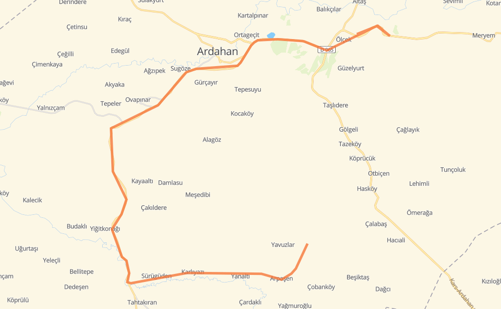
The distance from adı ? to Tulumba is 77 kilometers by road. Road takes approximately 1 hour and 3 minutes and goes through Ardahan, Arpaşen, Tellioğlu, Karlıyazı, Yanaltı, Sürügüden and Yiğitkonağı.
| Shortest distance by air | 22 km ✈️ |
| Car route length | 77 km 🚗 |
| Driving time | 1 h 3 min |
| Fuel amount | 6.2 L |
| Fuel cost | 10.9 AUD |
| Point | Distance | Time | Fuel | |
| Arpaşen | 0 km | 00 min | 0.0 L | |
|
16 km, 20 min
|
||||
| Karlıyazı | 16 km | 20 min | 1.1 L | |
|
3 km, 02 min
|
||||
| Sürügüden | 19 km | 22 min | 1.4 L | |
|
5 km, 03 min
|
||||
| Yiğitkonağı | 24 km | 26 min | 1.7 L | |
|
D 955 D955 20 km, 13 min
|
||||
| Güzçimeni | 44 km | 39 min | 3.2 L | |
|
D 955 7 km, 04 min
|
||||
| Ardahan | 52 km | 44 min | 3.9 L | |
|
D 955 D 010 / D 955 13 km, 09 min
|
||||
| Çamlıçatak | 65 km | 53 min | 5.1 L | |
|
D 965 12 km, 10 min
|
||||
| Tulumba | 77 km | 1 h 03 min | 5.3 L | |
Frequently Asked Questions
How much does it cost to drive from adı ? to Tulumba?
Fuel cost: 10.9 AUD
This fuel cost is calculated as: (Route length 77 km / 100 km) * (Fuel consumption 8 L/100 km) * (Fuel price 1.76 AUD / L)
You can adjust fuel consumption and fuel price here.
How long is a car ride from adı ? to Tulumba?
Driving time: 1 h 3 min
This time is calculated for driving at the maximum permitted speed, taking into account traffic rules restrictions.
- 68 km with a maximum speed 90 km/h = 45 min
- 4 km with a maximum speed 50 km/h = 4 min
- 5 km with a maximum speed 20 km/h = 13 min
The calculated driving time does not take into account intermediate stops and traffic jams.
How far is adı ? to Tulumba by land?
The distance between adı ? and Tulumba is 77 km by road.
Precise satellite coordinates of highways were used for this calculation. The start and finish points are the centers of adı ? and Tulumba respectively.
What city is halfway between adı ? and Tulumba?
Where is adı ? in relation to Tulumba?
adı ? is located 22 km south-west of Tulumba.
adı ? has geographic coordinates: latitude 40.94162, longitude 42.81206.
Tulumba has geographic coordinates: latitude 41.13086, longitude 42.87123.
Which highway goes from adı ? to Tulumba?
The route from adı ? to Tulumba follows D 955.
Other minor sections pass along the road:
- D 010 / D 955: 14 km
- D955: 12 km
- D 010: 5 km
- D 965: 1 km