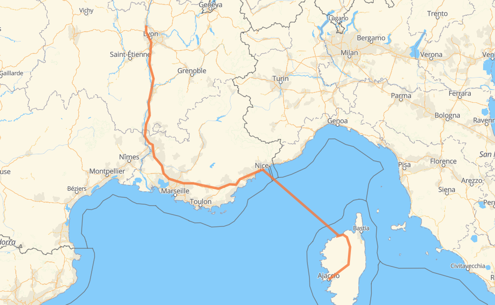
The distance from Ajaccio to Saint-Bernard is 818 kilometers by road including 456 kilometers on motorways. Road takes approximately 15 hours and 34 minutes and goes through Niza, Aix-en-Provence, Aviñón and Lyon.
How much does it cost to drive from Ajaccio to Saint-Bernard?
Fuel cost:
117.7 AUD
This fuel cost is calculated as: (Route length 818 km / 100 km) * (Fuel consumption 8 L/100 km) * (Fuel price 1.8 AUD / L)
You can adjust fuel consumption and fuel price here.
How long is a car ride from Ajaccio to Saint-Bernard?
Driving time:
15 h 34 min
This time is calculated for driving at the maximum permitted speed, taking into account traffic rules restrictions.
425 km with a maximum speed 110 km/h = 3 h 51 min
94 km with a maximum speed 90 km/h = 1 h 2 min
77 km with a maximum speed 80 km/h = 57 min
23 km with a maximum speed 70 km/h = 19 min
17 km with a maximum speed 50 km/h = 20 min
1 km with a maximum speed 30 km/h = 2 min
180 km with a maximum speed 20 km/h = 8 h 59 min
The calculated driving time does not take into account intermediate stops and traffic jams.
How far is Ajaccio to Saint-Bernard by land?
The distance between Ajaccio and Saint-Bernard is 818 km by road including 456 km on motorways.
Precise satellite coordinates of highways were used for this calculation. The start and finish points are the centers of Ajaccio and Saint-Bernard respectively.
How far is Ajaccio to Saint-Bernard by plane?
The shortest distance (air line, as the crow flies) between Ajaccio and Saint-Bernard is 550 km.
This distance is calculated using the Haversine formula as a great-circle distance between two points on the surface of a sphere. The start and finish points are the centers of Ajaccio and Saint-Bernard respectively. Actual distance between airports may be different.
How many hours is Ajaccio from Saint-Bernard by plane?
Boeing 737 airliner needs 41 min to cover the distance of 550 km at a cruising speed of 800 km/h.
Small plane "Cessna 172" needs 2 h 30 min to flight this distance at average speed of 220 km/h.
This time is approximate and do not take into account takeoff and landing times, airport location and other real world factors.
How long is a helicopter ride from Ajaccio to Saint-Bernard?
Fast helicopter "Eurocopter AS350" or "Hughes OH-6 Cayuse" need 2 h 17 min to cover the distance of 550 km at a cruising speed of 240 km/h.
Popular "Robinson R44" needs 2 h 37 min to flight this distance at average speed of 210 km/h.
This time is approximate and do not take into account takeoff and landing times, aerodrome location and other real world factors.
What city is halfway between Ajaccio and Saint-Bernard?
The halfway point between Ajaccio and Saint-Bernard is Les Termes. It is located about 6 km from the exact midpoint by road.
The distance from Les Termes to Ajaccio is 414 km and driving will take about 11 h 39 min. The road between Les Termes and Saint-Bernard has length 403 km and will take approximately 3 h 54 min.
The other cities located close to halfway point:
Le Muy is in 397 km from Ajaccio and 421 km from Saint-Bernard
Le Luc is in 422 km from Ajaccio and 396 km from Saint-Bernard
Roquebrune-sur-Argens is in 392 km from Ajaccio and 426 km from Saint-Bernard
Where is Ajaccio in relation to Saint-Bernard?
Ajaccio is located 550 km south-east of Saint-Bernard.
Ajaccio has geographic coordinates: latitude 41.9264, longitude 8.7376.
Saint-Bernard has geographic coordinates: latitude 45.94535, longitude 4.73427.
Which highway goes from Ajaccio to Saint-Bernard?
The route from Ajaccio to Saint-Bernard follows A 7, A 8.