Distance between Akama-Oye and Zanzi
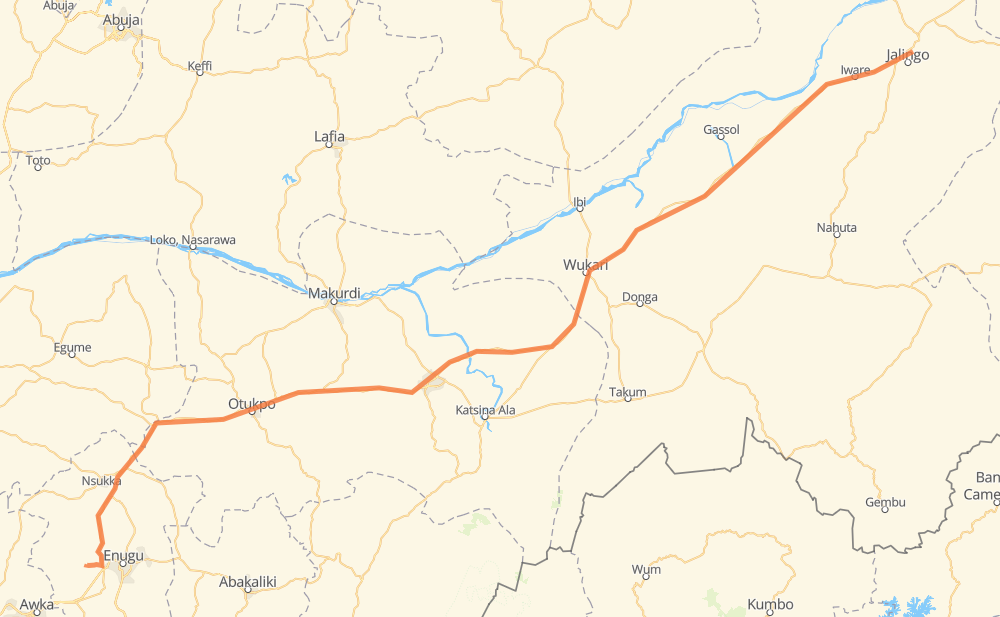
The distance from Akama-Oye to Zanzi is 610 kilometers by road. Road takes approximately 7 hours and 32 minutes and goes through Otukpo, Wukari, Ogbede, Ohebo, Ngalakwu, Eha-Alumona and Isienu.
| Shortest distance by air | 527 km ✈️ |
| Car route length | 610 km 🚗 |
| Driving time | 7 h 32 min |
| Fuel amount | 48.8 L |
| Fuel cost | 86.8 AUD |
| Point | Distance | Time | Fuel | |
| Akama-Oye | 0 km | 00 min | 0.0 L | |
|
28 km, 20 min
|
||||
| Ogbede | 28 km | 20 min | 0.7 L | |
|
A3 33 km, 24 min
|
||||
| Eha-Alumona | 61 km | 45 min | 3.7 L | |
|
A3 17 km, 12 min
|
||||
| Akpa | 77 km | 57 min | 6.0 L | |
|
A3 19 km, 14 min
|
||||
| Otu | 97 km | 1 h 12 min | 6.7 L | |
|
A3 47 km, 32 min
|
||||
| Ijami | 144 km | 1 h 44 min | 11.1 L | |
|
A3 34 km, 24 min
|
||||
| Otukpo | 177 km | 2 h 09 min | 12.3 L | |
|
A3 24 km, 17 min
|
||||
| Aliade | 201 km | 2 h 27 min | 16.1 L | |
|
A344 9 km, 06 min
|
||||
| Azel | 210 km | 2 h 34 min | 16.1 L | |
|
A344 A4 400 km, 4 h 58 min
|
||||
| Pantinapu | 610 km | 7 h 32 min | 48.6 L | |
Frequently Asked Questions
How much does it cost to drive from Akama-Oye to Zanzi?
Fuel cost: 86.8 AUD
This fuel cost is calculated as: (Route length 610 km / 100 km) * (Fuel consumption 8 L/100 km) * (Fuel price 1.78 AUD / L)
You can adjust fuel consumption and fuel price here.
How long is a car ride from Akama-Oye to Zanzi?
Driving time: 7 h 32 min
This time is calculated for driving at the maximum permitted speed, taking into account traffic rules restrictions.
- 73 km with a maximum speed 90 km/h = 48 min
- 535 km with a maximum speed 80 km/h = 6 h 41 min
- 1 km with a maximum speed 20 km/h = 1 min
The calculated driving time does not take into account intermediate stops and traffic jams.
How far is Akama-Oye to Zanzi by land?
The distance between Akama-Oye and Zanzi is 610 km by road.
Precise satellite coordinates of highways were used for this calculation. The start and finish points are the centers of Akama-Oye and Zanzi respectively.
How far is Akama-Oye to Zanzi by plane?
The shortest distance (air line, as the crow flies) between Akama-Oye and Zanzi is 527 km.
This distance is calculated using the Haversine formula as a great-circle distance between two points on the surface of a sphere. The start and finish points are the centers of Akama-Oye and Zanzi respectively. Actual distance between airports may be different.
How many hours is Akama-Oye from Zanzi by plane?
Boeing 737 airliner needs 39 min to cover the distance of 527 km at a cruising speed of 800 km/h.
Small plane "Cessna 172" needs 2 h 23 min to flight this distance at average speed of 220 km/h.
This time is approximate and do not take into account takeoff and landing times, airport location and other real world factors.
How long is a helicopter ride from Akama-Oye to Zanzi?
Fast helicopter "Eurocopter AS350" or "Hughes OH-6 Cayuse" need 2 h 11 min to cover the distance of 527 km at a cruising speed of 240 km/h.
Popular "Robinson R44" needs 2 h 30 min to flight this distance at average speed of 210 km/h.
This time is approximate and do not take into account takeoff and landing times, aerodrome location and other real world factors.
What city is halfway between Akama-Oye and Zanzi?
The halfway point between Akama-Oye and Zanzi is Ugba. It is located about 2 km from the exact midpoint by road.
The distance from Ugba to Akama-Oye is 303 km and driving will take about 3 h 44 min. The road between Ugba and Zanzi has length 307 km and will take approximately 3 h 48 min.
The other cities located close to halfway point:
Where is Akama-Oye in relation to Zanzi?
Akama-Oye is located 527 km south-west of Zanzi.
Akama-Oye has geographic coordinates: latitude 6.4458, longitude 7.3219.
Zanzi has geographic coordinates: latitude 8.94999, longitude 11.38333.
Which highway goes from Akama-Oye to Zanzi?
The route from Akama-Oye to Zanzi follows A4, A3.
Other minor sections pass along the road:
- F.121: 69 km
- A344: 67 km