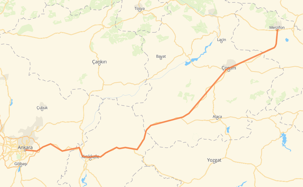
Distance between Ancara and Merzifon
The distance from Ancara to Merzifon is 300 kilometers by road. Road takes approximately 3 hours and 38 minutes and goes through Çorum, Küçük Kayaş Mah., Elmadağ, Bahçelievler Mah., Balışeyh, Delice and Sungurlu.
| Shortest distance by air | 245 km ✈️ |
| Car route length | 300 km 🚗 |
| Driving time | 3 h 38 min |
| Fuel amount | 24 L |
| Fuel cost | 43.3 AUD |
| Point | Distance | Time | Fuel | |
| Ancara | 0 km | 00 min | 0.0 L | |
|
D200 12 km, 08 min
|
||||
| Küçük Kayaş Mah. | 12 km | 08 min | 0.8 L | |
|
D200 7 km, 05 min
|
||||
| Gökçeyurt | 20 km | 13 min | 1.2 L | |
|
D200 14 km, 10 min
|
||||
| Elmadağ | 34 km | 24 min | 2.1 L | |
|
E88 D200 61 km, 44 min
|
||||
| Balışeyh | 95 km | 1 h 08 min | 6.8 L | |
|
D-200 28 km, 20 min
|
||||
| Delice | 124 km | 1 h 28 min | 9.2 L | |
|
D190 41 km, 30 min
|
||||
| Sungurlu | 165 km | 1 h 59 min | 12.7 L | |
|
D190 D785 42 km, 31 min
|
||||
| Sorsavuş | 207 km | 2 h 30 min | 15.8 L | |
|
D785 28 km, 19 min
|
||||
| Çorum | 235 km | 2 h 50 min | 18.3 L | |
|
D795 65 km, 48 min
|
||||
| Merzifon | 300 km | 3 h 38 min | 21.2 L | |
Hotels of Merzifon
Frequently Asked Questions
How much does it cost to drive from Ancara to Merzifon?
Fuel cost: 43.3 AUD
This fuel cost is calculated as: (Route length 300 km / 100 km) * (Fuel consumption 8 L/100 km) * (Fuel price 1.8 AUD / L)
You can adjust fuel consumption and fuel price here.
How long is a car ride from Ancara to Merzifon?
Driving time: 3 h 38 min
This time is calculated for driving at the maximum permitted speed, taking into account traffic rules restrictions.
- 78 km with a maximum speed 90 km/h = 52 min
- 222 km with a maximum speed 80 km/h = 2 h 46 min
The calculated driving time does not take into account intermediate stops and traffic jams.
How far is Ancara to Merzifon by land?
The distance between Ancara and Merzifon is 300 km by road.
Precise satellite coordinates of highways were used for this calculation. The start and finish points are the centers of Ancara and Merzifon respectively.
How far is Ancara to Merzifon by plane?
The shortest distance (air line, as the crow flies) between Ancara and Merzifon is 245 km.
This distance is calculated using the Haversine formula as a great-circle distance between two points on the surface of a sphere. The start and finish points are the centers of Ancara and Merzifon respectively. Actual distance between airports may be different.
How many hours is Ancara from Merzifon by plane?
Boeing 737 airliner needs 18 min to cover the distance of 245 km at a cruising speed of 800 km/h.
Small plane "Cessna 172" needs 1 h 6 min to flight this distance at average speed of 220 km/h.
This time is approximate and do not take into account takeoff and landing times, airport location and other real world factors.
How long is a helicopter ride from Ancara to Merzifon?
Fast helicopter "Eurocopter AS350" or "Hughes OH-6 Cayuse" need 1 h 1 min to cover the distance of 245 km at a cruising speed of 240 km/h.
Popular "Robinson R44" needs 1 h 10 min to flight this distance at average speed of 210 km/h.
This time is approximate and do not take into account takeoff and landing times, aerodrome location and other real world factors.
What city is halfway between Ancara and Merzifon?
The halfway point between Ancara and Merzifon is Çiftlik. It is located about 2 km from the exact midpoint by road.
The distance from Çiftlik to Ancara is 148 km and driving will take about 1 h 46 min. The road between Çiftlik and Merzifon has length 153 km and will take approximately 1 h 52 min.
The other cities located close to halfway point:
Where is Ancara in relation to Merzifon?
Ancara is located 245 km south-west of Merzifon.
Ancara has geographic coordinates: latitude 39.92152, longitude 32.85378.
Merzifon has geographic coordinates: latitude 40.86958, longitude 35.45867.