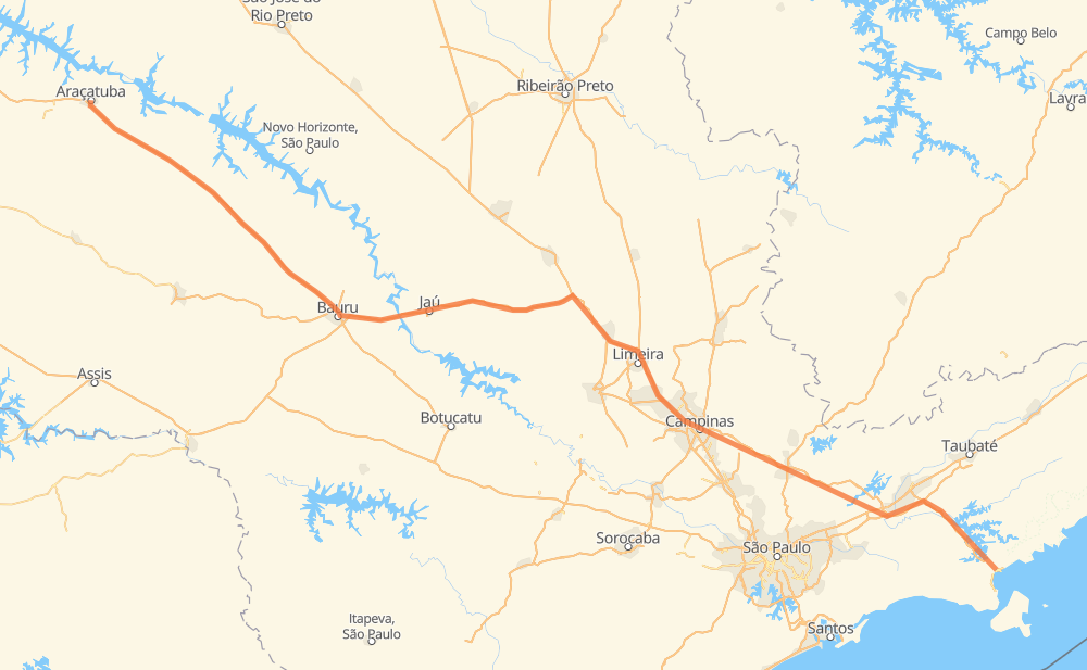
Distance between Araçatuba and Caraguatatuba
The distance from Araçatuba to Caraguatatuba is 687 kilometers by road including 655 kilometers on motorways. Road takes approximately 7 hours and goes through Rio Claro, Itatiba, Atibaia and Jacareí.
| Shortest distance by air | 582 km ✈️ |
| Car route length | 687 km 🚗 |
| Driving time | 7 h |
| Fuel amount | 55 L |
| Fuel cost | 99.5 AUD |
| Point | Distance | Time | Fuel | |
| -21.20799, -50.43902 | 0 km | 00 min | 0.0 L | |
|
SP-300 369 km, 3 h 33 min
|
||||
| Rio Claro | 369 km | 3 h 33 min | 58.1 L | |
|
SP-310 SP-330 73 km, 45 min
|
||||
| San Martin | 442 km | 4 h 19 min | 64.1 L | |
|
SP-065 40 km, 22 min
|
||||
| Itatiba | 482 km | 4 h 41 min | 67.1 L | |
|
SP-065 26 km, 14 min
|
||||
| Atibaia | 508 km | 4 h 55 min | 68.7 L | |
|
SP-065 16 km, 09 min
|
||||
| Bom Jesus dos Perdões | 524 km | 5 h 04 min | 70.7 L | |
|
SP-065 10 km, 05 min
|
||||
| Nazaré Paulista | 534 km | 5 h 10 min | 71.4 L | |
|
SP-065 60 km, 34 min
|
||||
| Jacareí | 594 km | 5 h 44 min | 76.3 L | |
|
SP-070 12 km, 07 min
|
||||
| Parque Interlagos | 606 km | 5 h 51 min | 77.4 L | |
|
SP-070 SP-099 49 km, 31 min
|
||||
| Bairro das Pitas | 655 km | 6 h 23 min | 81.3 L | |
|
SP-099 32 km, 37 min
|
||||
| Caraguatatuba | 687 km | 7 h 00 min | 83.2 L | |
Hotels of Caraguatatuba
Frequently Asked Questions
How much does it cost to drive from Araçatuba to Caraguatatuba?
Fuel cost: 99.5 AUD
This fuel cost is calculated as: (Route length 687 km / 100 km) * (Fuel consumption 8 L/100 km) * (Fuel price 1.81 AUD / L)
You can adjust fuel consumption and fuel price here.
How long is a car ride from Araçatuba to Caraguatatuba?
Driving time: 7 h
This time is calculated for driving at the maximum permitted speed, taking into account traffic rules restrictions.
- 455 km with a maximum speed 110 km/h = 4 h 8 min
- 143 km with a maximum speed 100 km/h = 1 h 25 min
- 5 km with a maximum speed 90 km/h = 3 min
- 51 km with a maximum speed 80 km/h = 38 min
- 9 km with a maximum speed 60 km/h = 8 min
- 3 km with a maximum speed 50 km/h = 3 min
- 19 km with a maximum speed 40 km/h = 27 min
- 3 km with a maximum speed 30 km/h = 5 min
The calculated driving time does not take into account intermediate stops and traffic jams.
How far is Araçatuba to Caraguatatuba by land?
The distance between Araçatuba and Caraguatatuba is 687 km by road including 655 km on motorways.
Precise satellite coordinates of highways were used for this calculation. The start and finish points are the centers of Araçatuba and Caraguatatuba respectively.
How far is Araçatuba to Caraguatatuba by plane?
The shortest distance (air line, as the crow flies) between Araçatuba and Caraguatatuba is 582 km.
This distance is calculated using the Haversine formula as a great-circle distance between two points on the surface of a sphere. The start and finish points are the centers of Araçatuba and Caraguatatuba respectively. Actual distance between airports may be different.
How many hours is Araçatuba from Caraguatatuba by plane?
Boeing 737 airliner needs 43 min to cover the distance of 582 km at a cruising speed of 800 km/h.
Small plane "Cessna 172" needs 2 h 38 min to flight this distance at average speed of 220 km/h.
This time is approximate and do not take into account takeoff and landing times, airport location and other real world factors.
How long is a helicopter ride from Araçatuba to Caraguatatuba?
Fast helicopter "Eurocopter AS350" or "Hughes OH-6 Cayuse" need 2 h 25 min to cover the distance of 582 km at a cruising speed of 240 km/h.
Popular "Robinson R44" needs 2 h 46 min to flight this distance at average speed of 210 km/h.
This time is approximate and do not take into account takeoff and landing times, aerodrome location and other real world factors.
What city is halfway between Araçatuba and Caraguatatuba?
The halfway point between Araçatuba and Caraguatatuba is Rio Claro. It is located about 25 km from the exact midpoint by road.
The distance from Rio Claro to Araçatuba is 369 km and driving will take about 3 h 33 min. The road between Rio Claro and Caraguatatuba has length 318 km and will take approximately 3 h 27 min.
The other cities located close to halfway point:
Where is Araçatuba in relation to Caraguatatuba?
Araçatuba is located 582 km north-west of Caraguatatuba.
Araçatuba has geographic coordinates: latitude -21.20799, longitude -50.43902.
Caraguatatuba has geographic coordinates: latitude -23.62028, longitude -45.41306.
Which highway goes from Araçatuba to Caraguatatuba?
The route from Araçatuba to Caraguatatuba follows SP-300, SP-065, BR-369, SP-225.
Other minor sections pass along the road:
- SP-099: 72 km
- SP-310: 53 km
- BR-364: 53 km
- BR-267: 50 km
- SP-330: 49 km
- BR-050: 49 km
- SP-070: 22 km
- SP-255: 5 km
- SP-055: 3 km
- BR-101: 3 km