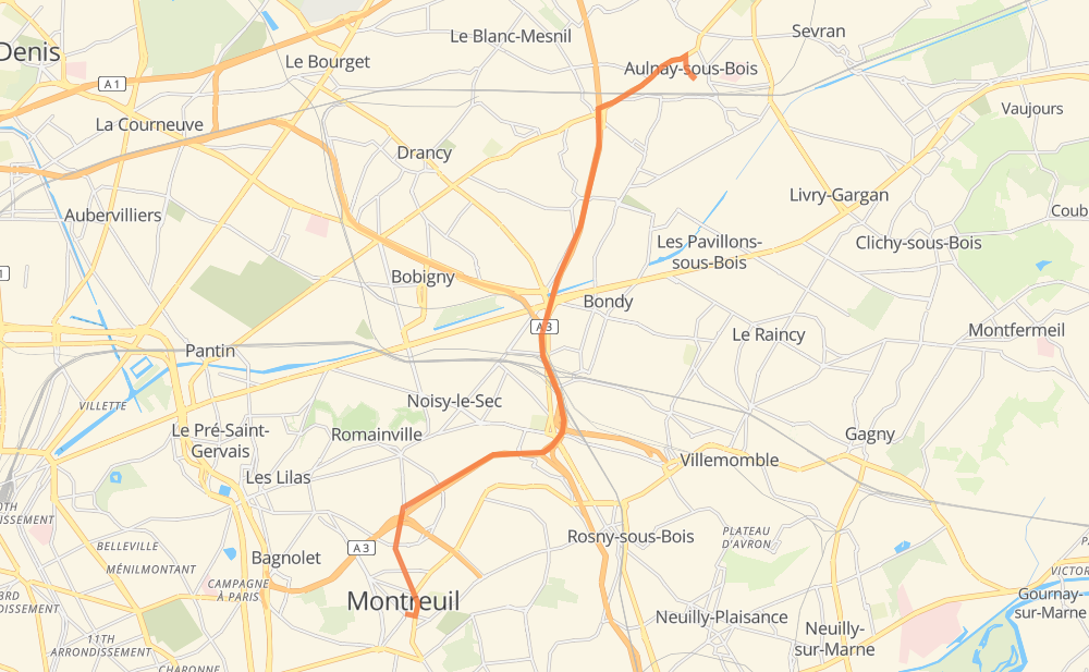
Distance between Aulnay-sous-Bois and Montreuil
The distance from Aulnay-sous-Bois to Montreuil is 12 kilometers by road including 8 kilometers on motorways. Road takes approximately 9 minutes and goes through Le Blanc-Mesnil, Bondy, Noisy-le-Sec, Rosny-sous-Bois and Romainville.
| Shortest distance by air | 9 km ✈️ |
| Car route length | 12 km 🚗 |
| Driving time | 9 min |
| Fuel amount | 0.9 L |
| Fuel cost | 1.6 AUD |
| Point | Distance | Time | Fuel | |
| Aulnay-sous-Bois | 0 km | 00 min | 0.0 L | |
|
D 115 5 km, 04 min
|
||||
| Bondy | 5 km | 04 min | 0.2 L | |
|
A 3 2 km, 01 min
|
||||
| Rosny-sous-Bois | 7 km | 05 min | 0.6 L | |
|
A 3 1 km, 00 min
|
||||
| Noisy-le-Sec | 8 km | 06 min | 0.6 L | |
|
A 3 2 km, 01 min
|
||||
| Romainville | 10 km | 08 min | 0.7 L | |
|
D 36bis 2 km, 01 min
|
||||
| Montreuil | 12 km | 09 min | 0.9 L | |
Hotels of Montreuil
Frequently Asked Questions
How much does it cost to drive from Aulnay-sous-Bois to Montreuil?
Fuel cost: 1.6 AUD
This fuel cost is calculated as: (Route length 12 km / 100 km) * (Fuel consumption 8 L/100 km) * (Fuel price 1.76 AUD / L)
You can adjust fuel consumption and fuel price here.
How long is a car ride from Aulnay-sous-Bois to Montreuil?
Driving time: 9 min
This time is calculated for driving at the maximum permitted speed, taking into account traffic rules restrictions.
- 2 km with a maximum speed 110 km/h = 1 min
- 2 km with a maximum speed 90 km/h = 1 min
- 4 km with a maximum speed 80 km/h = 2 min
- 2 km with a maximum speed 50 km/h = 2 min
The calculated driving time does not take into account intermediate stops and traffic jams.
How far is Aulnay-sous-Bois to Montreuil by land?
The distance between Aulnay-sous-Bois and Montreuil is 12 km by road including 8 km on motorways.
Precise satellite coordinates of highways were used for this calculation. The start and finish points are the centers of Aulnay-sous-Bois and Montreuil respectively.
What city is halfway between Aulnay-sous-Bois and Montreuil?
The halfway point between Aulnay-sous-Bois and Montreuil is Bondy. It is located about 1 km from the exact midpoint by road.
The distance from Bondy to Aulnay-sous-Bois is 5 km and driving will take about 4 min. The road between Bondy and Montreuil has length 7 km and will take approximately 5 min.
The other cities located close to halfway point:
Where is Aulnay-sous-Bois in relation to Montreuil?
Aulnay-sous-Bois is located 9 km north-east of Montreuil.
Aulnay-sous-Bois has geographic coordinates: latitude 48.93423, longitude 2.49979.
Montreuil has geographic coordinates: latitude 48.86234, longitude 2.44122.
Which highway goes from Aulnay-sous-Bois to Montreuil?
The route from Aulnay-sous-Bois to Montreuil follows A 3.
Other minor sections pass along the road:
- D 115: 1 km
- D 36bis: 1 km