Distance between Ayaracra and Nuñoa
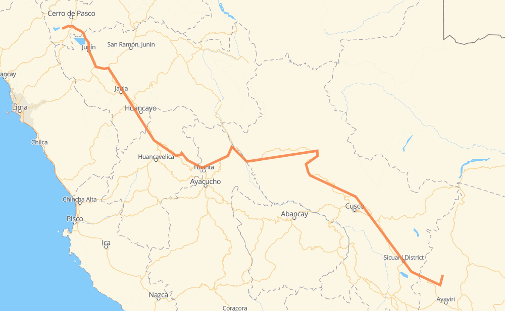
The distance from Ayaracra to Nuñoa is 1,351 kilometers by road. Road takes approximately 19 hours and 32 minutes and goes through Huancayo, Hidroeléctrica Rio Blanco, Carhuamayo, Junín, Tarmatambo, Jauja and Paucara.
| Shortest distance by air | 744 km ✈️ |
| Car route length | 1,351 km 🚗 |
| Driving time | 19 h 32 min |
| Fuel amount | 108.1 L |
| Fuel cost | 194.6 AUD |
| Point | Distance | Time | Fuel | |
| Ayaracra | 0 km | 00 min | 0.0 L | |
|
PA-570 PA-577 38 km, 34 min
|
||||
| Carhuamayo | 38 km | 34 min | 1.7 L | |
|
PE-3N 49 km, 33 min
|
||||
| Junín | 87 km | 1 h 08 min | 5.2 L | |
|
PE-3N PE-3SA 108 km, 1 h 32 min
|
||||
| Jauja | 195 km | 2 h 40 min | 14.7 L | |
|
PE-3SA PE-3S 36 km, 27 min
|
||||
| Huancayo | 232 km | 3 h 08 min | 16.5 L | |
|
PE-3SB PE-3S 433 km, 6 h 06 min
|
||||
| Kimbiri | 664 km | 9 h 14 min | 53.1 L | |
|
PE-28B 137 km, 1 h 39 min
|
||||
| Kepashiato | 801 km | 10 h 54 min | 63.6 L | |
|
PE-28B 111 km, 1 h 22 min
|
||||
| Quelloúno | 912 km | 12 h 16 min | 72.3 L | |
|
PE-28B 26 km, 19 min
|
||||
| Echarati | 939 km | 12 h 36 min | 74.6 L | |
|
PE-28B 464 km, 7 h 01 min
|
||||
| Nuñoa | 1,403 km | 19 h 37 min | 112.1 L | |
Frequently Asked Questions
How much does it cost to drive from Ayaracra to Nuñoa?
Fuel cost: 194.6 AUD
This fuel cost is calculated as: (Route length 1,351 km / 100 km) * (Fuel consumption 8 L/100 km) * (Fuel price 1.8 AUD / L)
You can adjust fuel consumption and fuel price here.
How long is a car ride from Ayaracra to Nuñoa?
Driving time: 19 h 32 min
This time is calculated for driving at the maximum permitted speed, taking into account traffic rules restrictions.
- 345 km with a maximum speed 90 km/h = 3 h 49 min
- 680 km with a maximum speed 80 km/h = 8 h 30 min
- 3 km with a maximum speed 70 km/h = 2 min
- 209 km with a maximum speed 60 km/h = 3 h 28 min
- 69 km with a maximum speed 50 km/h = 1 h 22 min
- 2 km with a maximum speed 45 km/h = 2 min
- 78 km with a maximum speed 40 km/h = 1 h 56 min
- 9 km with a maximum speed 35 km/h = 15 min
- 1 km with a maximum speed 30 km/h = 1 min
- 1 km with a maximum speed 20 km/h = 3 min
The calculated driving time does not take into account intermediate stops and traffic jams.
How far is Ayaracra to Nuñoa by land?
The distance between Ayaracra and Nuñoa is 1,351 km by road.
Precise satellite coordinates of highways were used for this calculation. The start and finish points are the centers of Ayaracra and Nuñoa respectively.
How far is Ayaracra to Nuñoa by plane?
The shortest distance (air line, as the crow flies) between Ayaracra and Nuñoa is 744 km.
This distance is calculated using the Haversine formula as a great-circle distance between two points on the surface of a sphere. The start and finish points are the centers of Ayaracra and Nuñoa respectively. Actual distance between airports may be different.
How many hours is Ayaracra from Nuñoa by plane?
Boeing 737 airliner needs 55 min to cover the distance of 744 km at a cruising speed of 800 km/h.
Small plane "Cessna 172" needs 3 h 22 min to flight this distance at average speed of 220 km/h.
This time is approximate and do not take into account takeoff and landing times, airport location and other real world factors.
How long is a helicopter ride from Ayaracra to Nuñoa?
Fast helicopter "Eurocopter AS350" or "Hughes OH-6 Cayuse" need 3 h 6 min to cover the distance of 744 km at a cruising speed of 240 km/h.
Popular "Robinson R44" needs 3 h 32 min to flight this distance at average speed of 210 km/h.
This time is approximate and do not take into account takeoff and landing times, aerodrome location and other real world factors.
What city is halfway between Ayaracra and Nuñoa?
The halfway point between Ayaracra and Nuñoa is Vista Alegre. It is located about 3 km from the exact midpoint by road.
The distance from Vista Alegre to Ayaracra is 679 km and driving will take about 9 h 24 min. The road between Vista Alegre and Nuñoa has length 673 km and will take approximately 10 h 7 min.
The other cities located close to halfway point:
Where is Ayaracra in relation to Nuñoa?
Ayaracra is located 744 km north-west of Nuñoa.
Ayaracra has geographic coordinates: latitude -10.83522, longitude -76.3934.
Nuñoa has geographic coordinates: latitude -14.47651, longitude -70.63606.
Which highway goes from Ayaracra to Nuñoa?
The route from Ayaracra to Nuñoa follows PE-28B, PE-3S.
Other minor sections pass along the road:
- PE-3N: 87 km
- PE-3SM: 67 km
- PE-3SA: 63 km
- HV-106: 49 km
- PE-3SB: 40 km
- AY-100: 38 km
- PU-100: 33 km
- PE-22B: 33 km
- PA-570: 14 km
- 3S: 5 km
- PA-577: 2 km