Distance between Carapebus and Candeias
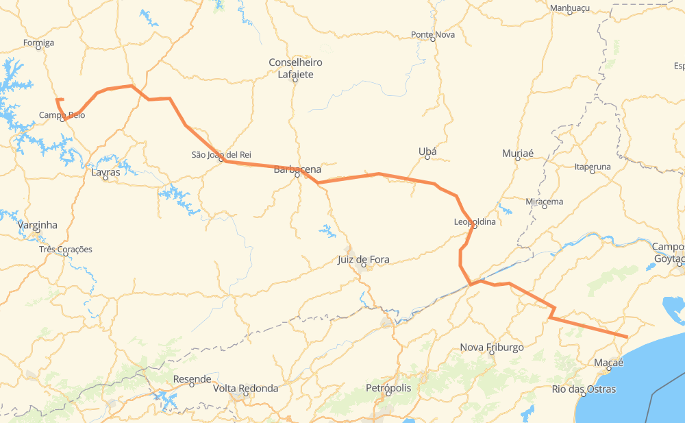
The distance from Carapebus to Candeias is 597 kilometers by road including 21 kilometers on motorways. Road takes approximately 7 hours and 23 minutes and goes through Barbacena, Além Paraíba, Leopoldina, Astolfo Dutra, Piraúba, Rio Pomba and Barroso.
| Shortest distance by air | 406 km ✈️ |
| Car route length | 597 km 🚗 |
| Driving time | 7 h 23 min |
| Fuel amount | 47.7 L |
| Fuel cost | 85.9 AUD |
| Point | Distance | Time | Fuel | |
| -22.18700, -41.66338 | 0 km | 00 min | 0.0 L | |
|
RJ-182 158 km, 1 h 48 min
|
||||
| Além Paraíba | 158 km | 1 h 48 min | 24.8 L | |
|
BR-116 52 km, 36 min
|
||||
| Leopoldina | 210 km | 2 h 24 min | 28.6 L | |
|
BR-116 BR-120 40 km, 28 min
|
||||
| Astolfo Dutra | 250 km | 2 h 53 min | 31.8 L | |
|
MG-285 17 km, 12 min
|
||||
| Piraúba | 267 km | 3 h 06 min | 33.1 L | |
|
MG-285 BR-265 20 km, 16 min
|
||||
| Rio Pomba | 287 km | 3 h 23 min | 34.8 L | |
|
BR-265 MG-448 77 km, 56 min
|
||||
| Barbacena | 364 km | 4 h 19 min | 41.0 L | |
|
BR-265 23 km, 21 min
|
||||
| Barroso | 387 km | 4 h 41 min | 42.8 L | |
|
BR-265 BR-478 84 km, 1 h 02 min
|
||||
| São Tiago | 471 km | 5 h 43 min | 49.3 L | |
|
BR-494 49 km, 37 min
|
||||
| Oliveira | 521 km | 6 h 20 min | 53.8 L | |
|
BR-369 76 km, 1 h 02 min
|
||||
| Candeias | 597 km | 7 h 23 min | 59.7 L | |
Frequently Asked Questions
How much does it cost to drive from Carapebus to Candeias?
Fuel cost: 85.9 AUD
This fuel cost is calculated as: (Route length 597 km / 100 km) * (Fuel consumption 8 L/100 km) * (Fuel price 1.8 AUD / L)
You can adjust fuel consumption and fuel price here.
How long is a car ride from Carapebus to Candeias?
Driving time: 7 h 23 min
This time is calculated for driving at the maximum permitted speed, taking into account traffic rules restrictions.
- 9 km with a maximum speed 110 km/h = 5 min
- 288 km with a maximum speed 90 km/h = 3 h 12 min
- 239 km with a maximum speed 80 km/h = 2 h 59 min
- 39 km with a maximum speed 60 km/h = 39 min
- 7 km with a maximum speed 50 km/h = 8 min
- 11 km with a maximum speed 40 km/h = 17 min
- 1 km with a maximum speed 30 km/h = 1 min
The calculated driving time does not take into account intermediate stops and traffic jams.
How far is Carapebus to Candeias by land?
The distance between Carapebus and Candeias is 597 km by road including 21 km on motorways.
Precise satellite coordinates of highways were used for this calculation. The start and finish points are the centers of Carapebus and Candeias respectively.
How far is Carapebus to Candeias by plane?
The shortest distance (air line, as the crow flies) between Carapebus and Candeias is 406 km.
This distance is calculated using the Haversine formula as a great-circle distance between two points on the surface of a sphere. The start and finish points are the centers of Carapebus and Candeias respectively. Actual distance between airports may be different.
How many hours is Carapebus from Candeias by plane?
Boeing 737 airliner needs 30 min to cover the distance of 406 km at a cruising speed of 800 km/h.
Small plane "Cessna 172" needs 1 h 50 min to flight this distance at average speed of 220 km/h.
This time is approximate and do not take into account takeoff and landing times, airport location and other real world factors.
How long is a helicopter ride from Carapebus to Candeias?
Fast helicopter "Eurocopter AS350" or "Hughes OH-6 Cayuse" need 1 h 41 min to cover the distance of 406 km at a cruising speed of 240 km/h.
Popular "Robinson R44" needs 1 h 56 min to flight this distance at average speed of 210 km/h.
This time is approximate and do not take into account takeoff and landing times, aerodrome location and other real world factors.
What city is halfway between Carapebus and Candeias?
The halfway point between Carapebus and Candeias is Rio Pomba. It is located about 11 km from the exact midpoint by road.
The distance from Rio Pomba to Carapebus is 287 km and driving will take about 3 h 23 min. The road between Rio Pomba and Candeias has length 310 km and will take approximately 4 h.
The other cities located close to halfway point:
Where is Carapebus in relation to Candeias?
Carapebus is located 406 km south-east of Candeias.
Carapebus has geographic coordinates: latitude -22.187, longitude -41.66338.
Candeias has geographic coordinates: latitude -20.76762, longitude -45.27638.