Distance between Coatzacoalcos and Veracruz
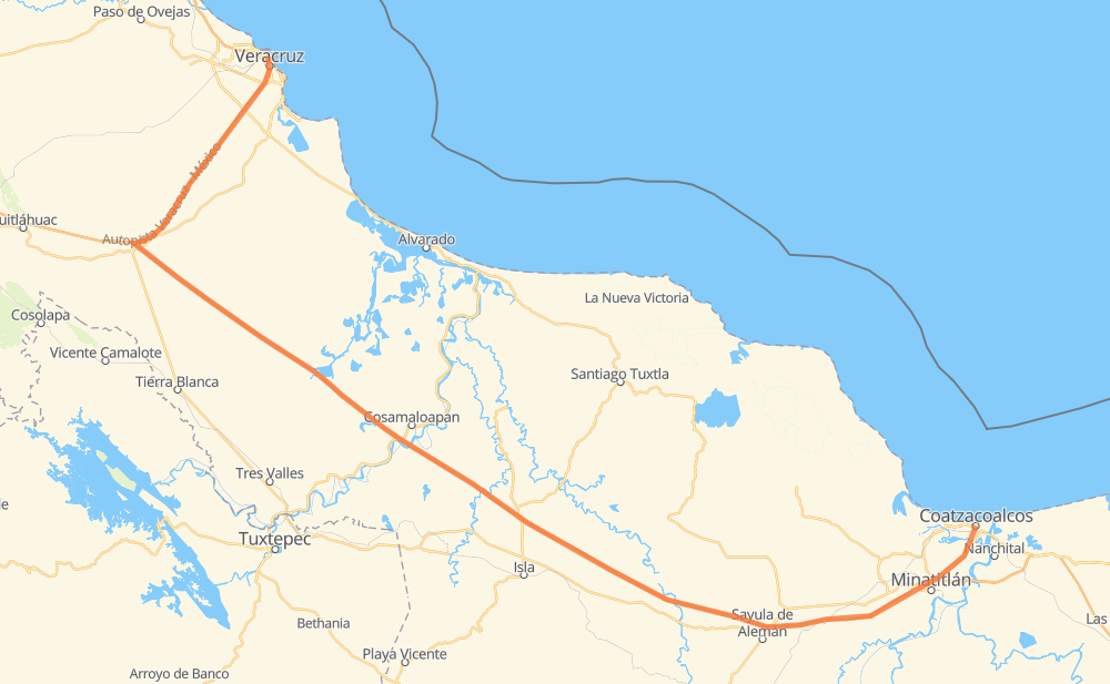
The distance from Coatzacoalcos to Veracruz is 313 kilometers by road including 287 kilometers on motorways. Road takes approximately 3 hours and 16 minutes and goes through San Pedro Mártir, Jamapa, Fraccionamiento los Limones, Colonia Luis Donaldo Colosio, Pichoapa, El Barrio and Piedra Herrada.
| Shortest distance by air | 213 km ✈️ |
| Car route length | 313 km 🚗 |
| Driving time | 3 h 16 min |
| Fuel amount | 25.1 L |
| Fuel cost | 45.1 AUD |
| Toll roads cost | 337 + ? MXN |
| Point | Distance | Time | Fuel | |
| Coatzacoalcos | 0 km | 00 min | 0.0 L | |
|
MEX 180 31 km, 22 min
|
||||
| San Pedro Mártir | 31 km | 22 min | 2.0 L | |
|
MEX 145D 138 km, 1 h 24 min
|
||||
| Pichoapa | 169 km | 1 h 46 min | 13.4 L | |
|
MEX 145D 39 km, 23 min
|
||||
| El Barrio | 208 km | 2 h 10 min | 16.5 L | |
|
MEX 145D 44 km, 26 min
|
||||
| Piedra Herrada | 252 km | 2 h 36 min | 20.1 L | |
|
MEX 145D 5 km, 03 min
|
||||
| San Antonio | 257 km | 2 h 40 min | 20.3 L | |
|
MEX 150D 7 km, 04 min
|
||||
| Las Limas | 264 km | 2 h 45 min | 20.9 L | |
|
MEX 150D 27 km, 16 min
|
||||
| Jamapa | 290 km | 3 h 01 min | 23.1 L | |
|
MEX 150D 3 km, 02 min
|
||||
| Paso de los Arrieros | 293 km | 3 h 03 min | 23.4 L | |
|
MEX 150D 20 km, 13 min
|
||||
| Veracruz | 313 km | 3 h 16 min | 24.5 L | |
Hotels of Veracruz
Frequently Asked Questions
How many toll booths are there from Coatzacoalcos to Veracruz?
There are 3 toll booths between Coatzacoalcos and Veracruz: Paso del Toro, Cosamaloapan and Acayucan.
How much does the toll booths cost from Coatzacoalcos to Veracruz?
Toll roads cost: Acayucan (?) + Cosamaloapan (229 MXN) + Paso del Toro (108 MXN) = 337 + ? MXN
How much does it cost to drive from Coatzacoalcos to Veracruz?
Fuel cost: 45.1 AUD
This fuel cost is calculated as: (Route length 313 km / 100 km) * (Fuel consumption 8 L/100 km) * (Fuel price 1.8 AUD / L)
You can adjust fuel consumption and fuel price here.
Toll roads cost: 337 + ? MXN
How long is a car ride from Coatzacoalcos to Veracruz?
Driving time: 3 h 16 min
This time is calculated for driving at the maximum permitted speed, taking into account traffic rules restrictions.
- 14 km with a maximum speed 110 km/h = 7 min
- 242 km with a maximum speed 100 km/h = 2 h 25 min
- 12 km with a maximum speed 90 km/h = 8 min
- 43 km with a maximum speed 80 km/h = 32 min
- 1 km with a maximum speed 50 km/h = 1 min
- 2 km with a maximum speed 40 km/h = 2 min
The calculated driving time does not take into account intermediate stops and traffic jams.
How far is Coatzacoalcos to Veracruz by land?
The distance between Coatzacoalcos and Veracruz is 313 km by road including 287 km on motorways.
Precise satellite coordinates of highways were used for this calculation. The start and finish points are the centers of Coatzacoalcos and Veracruz respectively.
How far is Coatzacoalcos to Veracruz by plane?
The shortest distance (air line, as the crow flies) between Coatzacoalcos and Veracruz is 213 km.
This distance is calculated using the Haversine formula as a great-circle distance between two points on the surface of a sphere. The start and finish points are the centers of Coatzacoalcos and Veracruz respectively. Actual distance between airports may be different.
How many hours is Coatzacoalcos from Veracruz by plane?
Boeing 737 airliner needs 15 min to cover the distance of 213 km at a cruising speed of 800 km/h.
Small plane "Cessna 172" needs 58 min to flight this distance at average speed of 220 km/h.
This time is approximate and do not take into account takeoff and landing times, airport location and other real world factors.
How long is a helicopter ride from Coatzacoalcos to Veracruz?
Fast helicopter "Eurocopter AS350" or "Hughes OH-6 Cayuse" need 53 min to cover the distance of 213 km at a cruising speed of 240 km/h.
Popular "Robinson R44" needs 1 h to flight this distance at average speed of 210 km/h.
This time is approximate and do not take into account takeoff and landing times, aerodrome location and other real world factors.
What city is halfway between Coatzacoalcos and Veracruz?
The halfway point between Coatzacoalcos and Veracruz is Pichoapa. It is located about 12 km from the exact midpoint by road.
The distance from Pichoapa to Coatzacoalcos is 169 km and driving will take about 1 h 46 min. The road between Pichoapa and Veracruz has length 145 km and will take approximately 1 h 30 min.
The other cities located close to halfway point:
Where is Coatzacoalcos in relation to Veracruz?
Coatzacoalcos is located 213 km south-east of Veracruz.
Coatzacoalcos has geographic coordinates: latitude 18.13967, longitude -94.45017.
Veracruz has geographic coordinates: latitude 19.20022, longitude -96.13857.
Which highway goes from Coatzacoalcos to Veracruz?
The route from Coatzacoalcos to Veracruz follows MEX 145D.
Other minor sections pass along the road:
- MEX 150D: 53 km
- MEX 180: 16 km
- MEX 180D: 6 km