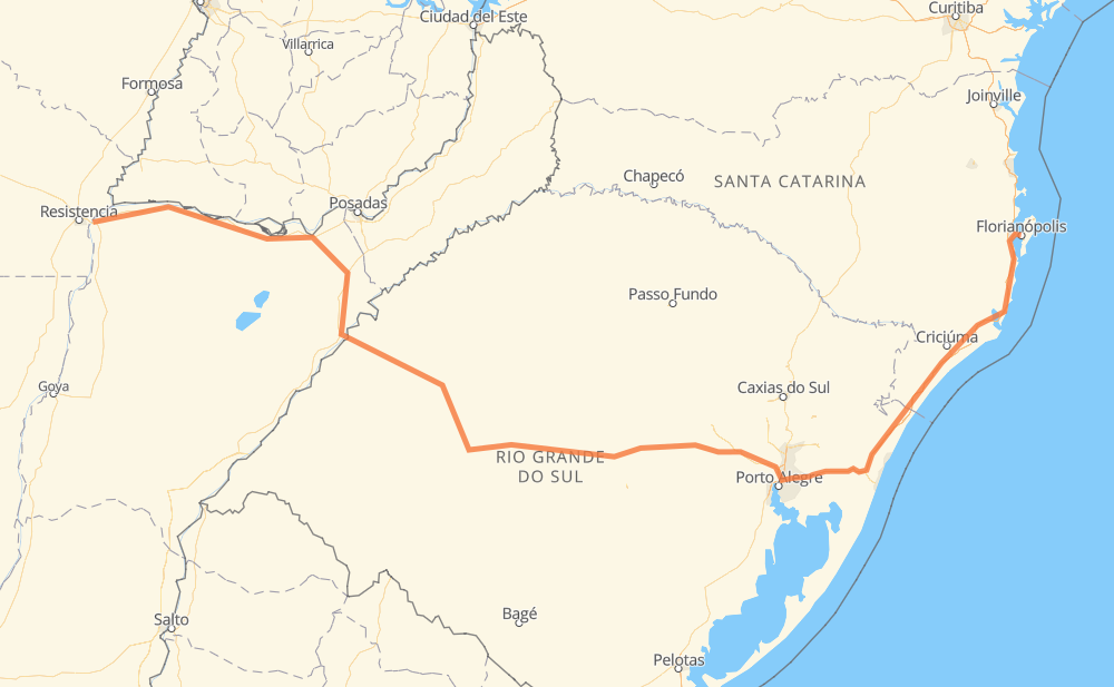
Distance between Corrientes and Florianópolis
The distance from Corrientes to Florianópolis is 1,430 kilometers by road including 453 kilometers on motorways. Road takes approximately 16 hours and 8 minutes and goes through Barrio Jose Maria Ponce, San Cosme, Ituzaingó, Gobernador Virasoro, Santo Tomé, Gaspar Dutra and Nossa Senhora de Lourdes.
| Shortest distance by air | 1,014 km ✈️ |
| Car route length | 1,430 km 🚗 |
| Driving time | 16 h 8 min |
| Fuel amount | 114.4 L |
| Fuel cost | 203.6 AUD |
| Point | Distance | Time | Fuel | |
| Corrientes | 0 km | 00 min | 0.0 L | |
|
RP5 6 km, 06 min
|
||||
| Barrio Jose Maria Ponce | 6 km | 06 min | 0.5 L | |
|
RN12 223 km, 2 h 40 min
|
||||
| Ituzaingó | 229 km | 2 h 47 min | 17.8 L | |
|
RN12 RN120 103 km, 1 h 12 min
|
||||
| Gobernador Virasoro | 332 km | 3 h 59 min | 25.5 L | |
|
RN14 38 km, 29 min
|
||||
| Santo Tomé | 370 km | 4 h 28 min | 27.8 L | |
|
RN14 BR-287 175 km, 2 h 00 min
|
||||
| Gaspar Dutra | 545 km | 6 h 29 min | 43.6 L | |
|
BR-287 37 km, 25 min
|
||||
| Nossa Senhora de Lourdes | 582 km | 6 h 54 min | 45.9 L | |
|
BR-287 126 km, 1 h 28 min
|
||||
| Camobi | 709 km | 8 h 22 min | 56.6 L | |
|
RSC-287 96 km, 1 h 12 min
|
||||
| Rincão Comprido | 804 km | 9 h 35 min | 64.3 L | |
|
RSC-153 BR-101 627 km, 6 h 32 min
|
||||
| Florianópolis | 1,431 km | 16 h 08 min | 114.4 L | |
Hotels of Florianópolis
Frequently Asked Questions
How much does it cost to drive from Corrientes to Florianópolis?
Fuel cost: 203.6 AUD
This fuel cost is calculated as: (Route length 1,430 km / 100 km) * (Fuel consumption 8 L/100 km) * (Fuel price 1.78 AUD / L)
You can adjust fuel consumption and fuel price here.
How long is a car ride from Corrientes to Florianópolis?
Driving time: 16 h 8 min
This time is calculated for driving at the maximum permitted speed, taking into account traffic rules restrictions.
- 309 km with a maximum speed 110 km/h = 2 h 48 min
- 102 km with a maximum speed 100 km/h = 1 h
- 573 km with a maximum speed 90 km/h = 6 h 21 min
- 391 km with a maximum speed 80 km/h = 4 h 53 min
- 40 km with a maximum speed 60 km/h = 40 min
- 6 km with a maximum speed 50 km/h = 6 min
- 9 km with a maximum speed 40 km/h = 13 min
- 1 km with a maximum speed 30 km/h = 1 min
The calculated driving time does not take into account intermediate stops and traffic jams.
How far is Corrientes to Florianópolis by land?
The distance between Corrientes and Florianópolis is 1,430 km by road including 453 km on motorways.
Precise satellite coordinates of highways were used for this calculation. The start and finish points are the centers of Corrientes and Florianópolis respectively.
How far is Corrientes to Florianópolis by plane?
The shortest distance (air line, as the crow flies) between Corrientes and Florianópolis is 1,014 km.
This distance is calculated using the Haversine formula as a great-circle distance between two points on the surface of a sphere. The start and finish points are the centers of Corrientes and Florianópolis respectively. Actual distance between airports may be different.
How many hours is Corrientes from Florianópolis by plane?
Boeing 737 airliner needs 1 h 16 min to cover the distance of 1,014 km at a cruising speed of 800 km/h.
Small plane "Cessna 172" needs 4 h 36 min to flight this distance at average speed of 220 km/h.
This time is approximate and do not take into account takeoff and landing times, airport location and other real world factors.
How long is a helicopter ride from Corrientes to Florianópolis?
Fast helicopter "Eurocopter AS350" or "Hughes OH-6 Cayuse" need 4 h 13 min to cover the distance of 1,014 km at a cruising speed of 240 km/h.
Popular "Robinson R44" needs 4 h 49 min to flight this distance at average speed of 210 km/h.
This time is approximate and do not take into account takeoff and landing times, aerodrome location and other real world factors.
What city is halfway between Corrientes and Florianópolis?
The halfway point between Corrientes and Florianópolis is Camobi. It is located about 6 km from the exact midpoint by road.
The distance from Camobi to Corrientes is 709 km and driving will take about 8 h 22 min. The road between Camobi and Florianópolis has length 721 km and will take approximately 7 h 45 min.
The other cities located close to halfway point:
Where is Corrientes in relation to Florianópolis?
Corrientes is located 1,014 km west of Florianópolis.
Corrientes has geographic coordinates: latitude -27.4687, longitude -58.83123.
Florianópolis has geographic coordinates: latitude -27.5973, longitude -48.54961.
Which highway goes from Corrientes to Florianópolis?
The route from Corrientes to Florianópolis follows BR-101, BR-287, RN12, RSC-287.
Other minor sections pass along the road:
- BR-290: 94 km
- RN14: 73 km
- RN120: 57 km
- BR-386: 54 km
- RSC-153: 42 km
- BR-285: 19 km
- BR-448: 12 km
- RN121: 8 km
- BR-282: 5 km
- BR-472: 5 km
- BR-158: 5 km
- ERS-176: 4 km
- BR-116: 2 km