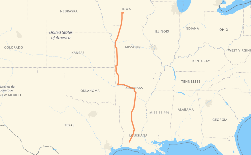
The distance from Des Moines to Iowa is 1,545 kilometers by road including 1,000 kilometers on motorways. Road takes approximately 15 hours and 49 minutes and goes through Kansas City, Springdale, Fayetteville, Little Rock and Alexandria.
How much does it cost to drive from Des Moines to Iowa?
Fuel cost:
222.5 AUD
This fuel cost is calculated as: (Route length 1,545 km / 100 km) * (Fuel consumption 8 L/100 km) * (Fuel price 1.8 AUD / L)
You can adjust fuel consumption and fuel price here.
How long is a car ride from Des Moines to Iowa?
Driving time:
15 h 49 min
This time is calculated for driving at the maximum permitted speed, taking into account traffic rules restrictions.
866 km with a maximum speed 110 km/h = 7 h 52 min
83 km with a maximum speed 105 km/h = 47 min
14 km with a maximum speed 100 km/h = 8 min
11 km with a maximum speed 97 km/h = 6 min
150 km with a maximum speed 90 km/h = 1 h 39 min
39 km with a maximum speed 89 km/h = 26 min
7 km with a maximum speed 80 km/h = 5 min
361 km with a maximum speed 80 km/h = 4 h 31 min
12 km with a maximum speed 72 km/h = 10 min
The calculated driving time does not take into account intermediate stops and traffic jams.
How far is Des Moines to Iowa by land?
The distance between Des Moines and Iowa is 1,545 km by road including 1,000 km on motorways.
Precise satellite coordinates of highways were used for this calculation. The start and finish points are the centers of Des Moines and Iowa respectively.
How far is Des Moines to Iowa by plane?
The shortest distance (air line, as the crow flies) between Des Moines and Iowa is 1,264 km.
This distance is calculated using the Haversine formula as a great-circle distance between two points on the surface of a sphere. The start and finish points are the centers of Des Moines and Iowa respectively. Actual distance between airports may be different.
How many hours is Des Moines from Iowa by plane?
Boeing 737 airliner needs 1 h 34 min to cover the distance of 1,264 km at a cruising speed of 800 km/h.
Small plane "Cessna 172" needs 5 h 44 min to flight this distance at average speed of 220 km/h.
This time is approximate and do not take into account takeoff and landing times, airport location and other real world factors.
How long is a helicopter ride from Des Moines to Iowa?
Fast helicopter "Eurocopter AS350" or "Hughes OH-6 Cayuse" need 5 h 16 min to cover the distance of 1,264 km at a cruising speed of 240 km/h.
Popular "Robinson R44" needs 6 h 1 min to flight this distance at average speed of 210 km/h.
This time is approximate and do not take into account takeoff and landing times, aerodrome location and other real world factors.
What city is halfway between Des Moines and Iowa?
The halfway point between Des Moines and Iowa is Chester. It is located about 42 km from the exact midpoint by road.
The distance from Chester to Des Moines is 730 km and driving will take about 6 h 46 min. The road between Chester and Iowa has length 815 km and will take approximately 9 h 2 min.
The other cities located close to halfway point:
Shady Grove is in 819 km from Des Moines and 726 km from Iowa
Knoxville is in 843 km from Des Moines and 702 km from Iowa
West Fork is in 701 km from Des Moines and 844 km from Iowa
Where is Des Moines in relation to Iowa?
Des Moines is located 1,264 km north of Iowa.
Des Moines has geographic coordinates: latitude 41.59106, longitude -93.60371.
Iowa has geographic coordinates: latitude 30.23688, longitude -93.01376.
Which highway goes from Des Moines to Iowa?
The route from Des Moines to Iowa follows US 167, I 49, US 71, I 35, I 40, US 165.