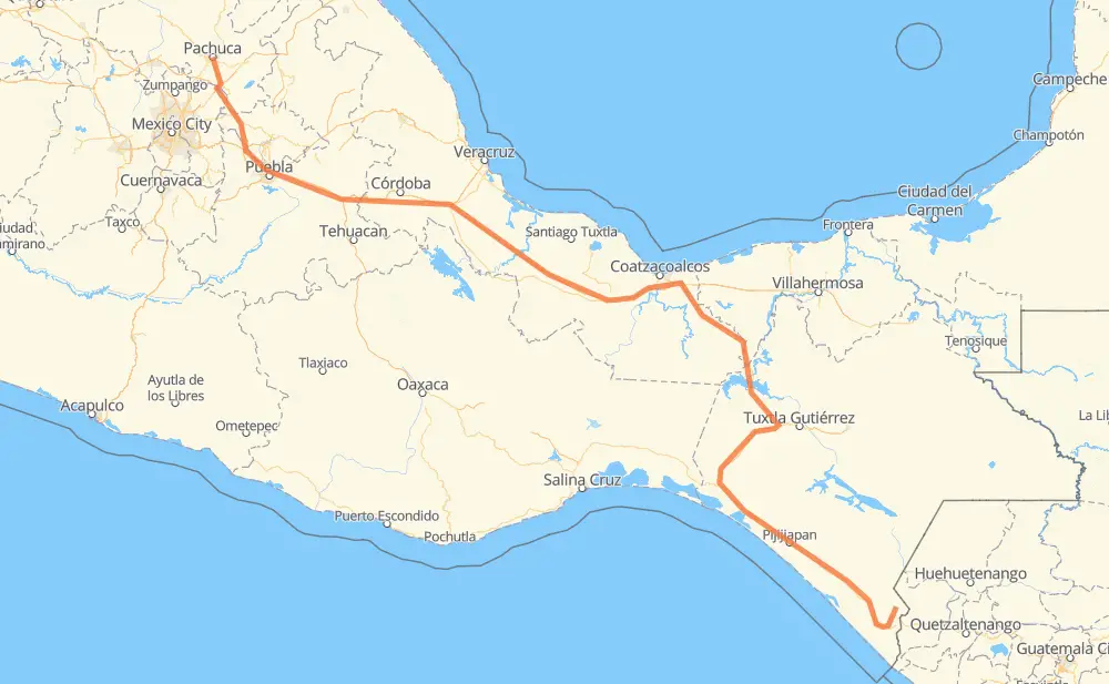
Distance between El Aguilar and Pachuca
The distance from El Aguilar to Pachuca is 1,205 kilometers by road including 596 kilometers on motorways. Road takes approximately 13 hours and 29 minutes and goes through Tapachula, Orizaba, Carrillo Puerto, Viva Mexico, Álvaro Obregón, Huehuetan and Huixtla.
| Shortest distance by air | 892 km ✈️ |
| Car route length | 1,205 km 🚗 |
| Driving time | 13 h 29 min |
| Fuel amount | 96.4 L |
| Fuel cost | 171.6 AUD |
| Toll roads cost | 1,067 + ? MXN |
| Point | Distance | Time | Fuel | |
| Iturbide | 0 km | 00 min | 0.0 L | |
|
14 km, 13 min
|
||||
| Carrillo Puerto | 14 km | 13 min | 0.6 L | |
|
CHIS 229 17 km, 11 min
|
||||
| Tapachula | 30 km | 25 min | 2.2 L | |
|
MEX 200 12 km, 07 min
|
||||
| Álvaro Obregón | 42 km | 33 min | 2.6 L | |
|
MEX 200 12 km, 08 min
|
||||
| Huehuetan | 54 km | 41 min | 4.1 L | |
|
MEX 200 18 km, 11 min
|
||||
| Huixtla | 72 km | 53 min | 5.2 L | |
|
MEX 200 63 km, 43 min
|
||||
| Mapastepec | 135 km | 1 h 37 min | 10.4 L | |
|
MEX 200 6 km, 04 min
|
||||
| 8 de Septiembre | 141 km | 1 h 41 min | 11.2 L | |
|
MEX 200 MEX 180D 773 km, 8 h 21 min
|
||||
| Orizaba | 914 km | 10 h 02 min | 72.8 L | |
|
MEX 150D 301 km, 3 h 26 min
|
||||
| Pachuca | 1,215 km | 13 h 29 min | 96.6 L | |
Hotels of Pachuca
Frequently Asked Questions
How many toll booths are there from El Aguilar to Pachuca?
There are 17 toll booths between El Aguilar and Pachuca: Fortín, Cuitláhuac, Cosamaloapan, Acayucan, Antonio Dovali, Las Choapas, Tulancingo, San Martin Texmelucan, San Martín, Amozoc 2, Amozoc, Esperanza 27, Arriaga, Jiquipilas, Ocozocoautla, Ocozocoautla 182 and Malpasito.
How much does the toll booths cost from El Aguilar to Pachuca?
Toll roads cost: Arriaga (37 MXN) + Jiquipilas (15-60 MXN) + Ocozocoautla (38 MXN) + Ocozocoautla 182 (82 MXN) + Malpasito (82 MXN) + Las Choapas (82 MXN) + Antonio Dovali (20 MXN) + Acayucan (?) + Cosamaloapan (229 MXN) + Cuitláhuac (114 MXN) + Fortín (33 MXN) + Esperanza 27 (140 MXN) + Amozoc (72 MXN) + Amozoc 2 (81 MXN) + San Martín (42 MXN) + San Martin Texmelucan (?) + Tulancingo (?) = 1,067 + ? MXN
How much does it cost to drive from El Aguilar to Pachuca?
Fuel cost: 171.6 AUD
This fuel cost is calculated as: (Route length 1,205 km / 100 km) * (Fuel consumption 8 L/100 km) * (Fuel price 1.78 AUD / L)
You can adjust fuel consumption and fuel price here.
Toll roads cost: 1,067 + ? MXN
How long is a car ride from El Aguilar to Pachuca?
Driving time: 13 h 29 min
This time is calculated for driving at the maximum permitted speed, taking into account traffic rules restrictions.
- 88 km with a maximum speed 110 km/h = 48 min
- 320 km with a maximum speed 100 km/h = 3 h 12 min
- 485 km with a maximum speed 90 km/h = 5 h 23 min
- 308 km with a maximum speed 80 km/h = 3 h 51 min
- 4 km with a maximum speed 70 km/h = 3 min
- 8 km with a maximum speed 50 km/h = 9 min
- 1 km with a maximum speed 40 km/h = 1 min
The calculated driving time does not take into account intermediate stops and traffic jams.
How far is El Aguilar to Pachuca by land?
The distance between El Aguilar and Pachuca is 1,205 km by road including 596 km on motorways.
Precise satellite coordinates of highways were used for this calculation. The start and finish points are the centers of El Aguilar and Pachuca respectively.
How far is El Aguilar to Pachuca by plane?
The shortest distance (air line, as the crow flies) between El Aguilar and Pachuca is 892 km.
This distance is calculated using the Haversine formula as a great-circle distance between two points on the surface of a sphere. The start and finish points are the centers of El Aguilar and Pachuca respectively. Actual distance between airports may be different.
How many hours is El Aguilar from Pachuca by plane?
Boeing 737 airliner needs 1 h 6 min to cover the distance of 892 km at a cruising speed of 800 km/h.
Small plane "Cessna 172" needs 4 h 3 min to flight this distance at average speed of 220 km/h.
This time is approximate and do not take into account takeoff and landing times, airport location and other real world factors.
How long is a helicopter ride from El Aguilar to Pachuca?
Fast helicopter "Eurocopter AS350" or "Hughes OH-6 Cayuse" need 3 h 43 min to cover the distance of 892 km at a cruising speed of 240 km/h.
Popular "Robinson R44" needs 4 h 14 min to flight this distance at average speed of 210 km/h.
This time is approximate and do not take into account takeoff and landing times, aerodrome location and other real world factors.
What city is halfway between El Aguilar and Pachuca?
The halfway point between El Aguilar and Pachuca is Ixhuatlán del Sureste. It is located about 14 km from the exact midpoint by road.
The distance from Ixhuatlán del Sureste to El Aguilar is 589 km and driving will take about 6 h 45 min. The road between Ixhuatlán del Sureste and Pachuca has length 616 km and will take approximately 6 h 43 min.
The other cities located close to halfway point:
Where is El Aguilar in relation to Pachuca?
El Aguilar is located 892 km south-east of Pachuca.
El Aguilar has geographic coordinates: latitude 15.09277, longitude -92.18309.
Pachuca has geographic coordinates: latitude 20.11654, longitude -98.74135.
Which highway goes from El Aguilar to Pachuca?
The route from El Aguilar to Pachuca follows MEX 150D, MEX 200, MEX 180D, MEX 145D.
Other minor sections pass along the road:
- MEX M40D: 73 km
- MEX 195D: 70 km
- MEX 190D: 23 km
- MEX 190: 7 km
- MEX 180: 7 km
- MEX 132: 6 km
- CHIS 229: 5 km
- Tapachula Arriaga: 2 km
- MEX 140D: 2 km