Distance between Encarnación de Díaz and Amacueca
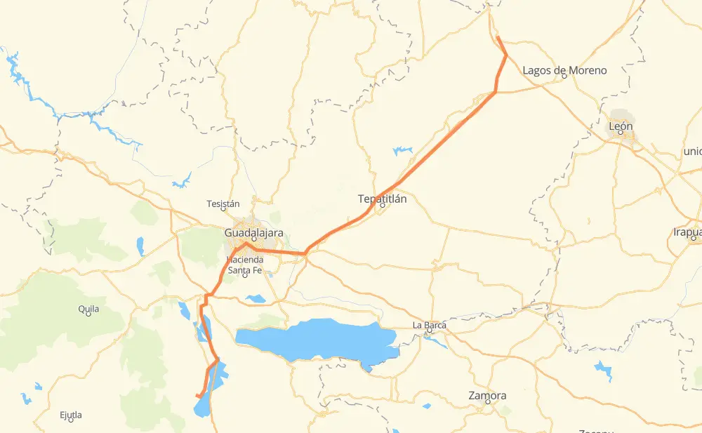
The distance from Encarnación de Díaz to Amacueca is 272 kilometers by road including 205 kilometers on motorways. Road takes approximately 2 hours and 54 minutes and goes through Tonalá, Valle de Guadalupe, Pegueros and Lomas de Santa Anita.
| Shortest distance by air | 220 km ✈️ |
| Car route length | 272 km 🚗 |
| Driving time | 2 h 54 min |
| Fuel amount | 21.7 L |
| Fuel cost | 38.3 AUD |
| Toll roads cost | 541 + ? MXN |
| Point | Distance | Time | Fuel | |
| Encarnación de Díaz | 0 km | 00 min | 0.0 L | |
|
JAL 212 MEX 80D 79 km, 47 min
|
||||
| Valle de Guadalupe | 79 km | 47 min | 6.0 L | |
|
MEX 80D 11 km, 05 min
|
||||
| Pegueros | 89 km | 53 min | 6.6 L | |
|
MEX 80D 74 km, 44 min
|
||||
| Tonalá | 163 km | 1 h 37 min | 12.4 L | |
|
MEX 15D MEX 80 40 km, 29 min
|
||||
| Lomas de Santa Anita | 203 km | 2 h 07 min | 15.8 L | |
|
MEX 15 8 km, 06 min
|
||||
| Buenavista | 212 km | 2 h 13 min | 16.7 L | |
|
MEX 15 MEX 54D 22 km, 13 min
|
||||
| San José de los Pozos | 233 km | 2 h 26 min | 17.2 L | |
|
MEX 54D 20 km, 12 min
|
||||
| El Zapote | 254 km | 2 h 39 min | 20.1 L | |
|
18 km, 14 min
|
||||
| Amacueca | 272 km | 2 h 54 min | 20.4 L | |
Frequently Asked Questions
How many toll booths are there from Encarnación de Díaz to Amacueca?
There are 4 toll booths between Encarnación de Díaz and Amacueca: Encarnacion De Diaz, Jalostotitlan, Tepatitlan and La Joya.
How much does the toll booths cost from Encarnación de Díaz to Amacueca?
Toll roads cost: Encarnacion De Diaz (150 MXN) + Jalostotitlan (177 MXN) + Tepatitlan (214 MXN) + La Joya (?) = 541 + ? MXN
How much does it cost to drive from Encarnación de Díaz to Amacueca?
Fuel cost: 38.3 AUD
This fuel cost is calculated as: (Route length 272 km / 100 km) * (Fuel consumption 8 L/100 km) * (Fuel price 1.76 AUD / L)
You can adjust fuel consumption and fuel price here.
Toll roads cost: 541 + ? MXN
How long is a car ride from Encarnación de Díaz to Amacueca?
Driving time: 2 h 54 min
This time is calculated for driving at the maximum permitted speed, taking into account traffic rules restrictions.
- 92 km with a maximum speed 110 km/h = 50 min
- 75 km with a maximum speed 100 km/h = 44 min
- 30 km with a maximum speed 90 km/h = 19 min
- 68 km with a maximum speed 80 km/h = 50 min
- 1 km with a maximum speed 60 km/h = 1 min
- 6 km with a maximum speed 50 km/h = 7 min
The calculated driving time does not take into account intermediate stops and traffic jams.
How far is Encarnación de Díaz to Amacueca by land?
The distance between Encarnación de Díaz and Amacueca is 272 km by road including 205 km on motorways.
Precise satellite coordinates of highways were used for this calculation. The start and finish points are the centers of Encarnación de Díaz and Amacueca respectively.
How far is Encarnación de Díaz to Amacueca by plane?
The shortest distance (air line, as the crow flies) between Encarnación de Díaz and Amacueca is 220 km.
This distance is calculated using the Haversine formula as a great-circle distance between two points on the surface of a sphere. The start and finish points are the centers of Encarnación de Díaz and Amacueca respectively. Actual distance between airports may be different.
How many hours is Encarnación de Díaz from Amacueca by plane?
Boeing 737 airliner needs 16 min to cover the distance of 220 km at a cruising speed of 800 km/h.
Small plane "Cessna 172" needs 1 h to flight this distance at average speed of 220 km/h.
This time is approximate and do not take into account takeoff and landing times, airport location and other real world factors.
How long is a helicopter ride from Encarnación de Díaz to Amacueca?
Fast helicopter "Eurocopter AS350" or "Hughes OH-6 Cayuse" need 55 min to cover the distance of 220 km at a cruising speed of 240 km/h.
Popular "Robinson R44" needs 1 h 2 min to flight this distance at average speed of 210 km/h.
This time is approximate and do not take into account takeoff and landing times, aerodrome location and other real world factors.
What city is halfway between Encarnación de Díaz and Amacueca?
The halfway point between Encarnación de Díaz and Amacueca is Tonalá. It is located about 27 km from the exact midpoint by road.
The distance from Tonalá to Encarnación de Díaz is 163 km and driving will take about 1 h 37 min. The road between Tonalá and Amacueca has length 109 km and will take approximately 1 h 16 min.
Where is Encarnación de Díaz in relation to Amacueca?
Encarnación de Díaz is located 220 km north-east of Amacueca.
Encarnación de Díaz has geographic coordinates: latitude 21.52661, longitude -102.23987.
Amacueca has geographic coordinates: latitude 20.01144, longitude -103.60059.
Which highway goes from Encarnación de Díaz to Amacueca?
The route from Encarnación de Díaz to Amacueca follows MEX 80D.
Other minor sections pass along the road:
- MEX 54D: 63 km
- MEX 70: 36 km
- MEX 80: 36 km
- MEX 15D: 26 km
- MEX 15: 26 km
- MEX 54: 14 km
- MEX 90: 9 km
- MEX 45D: 8 km
- MEX 23: 5 km
- MEX 90D: 3 km
- JAL 212: 3 km