Distance between Felícia and Cidades
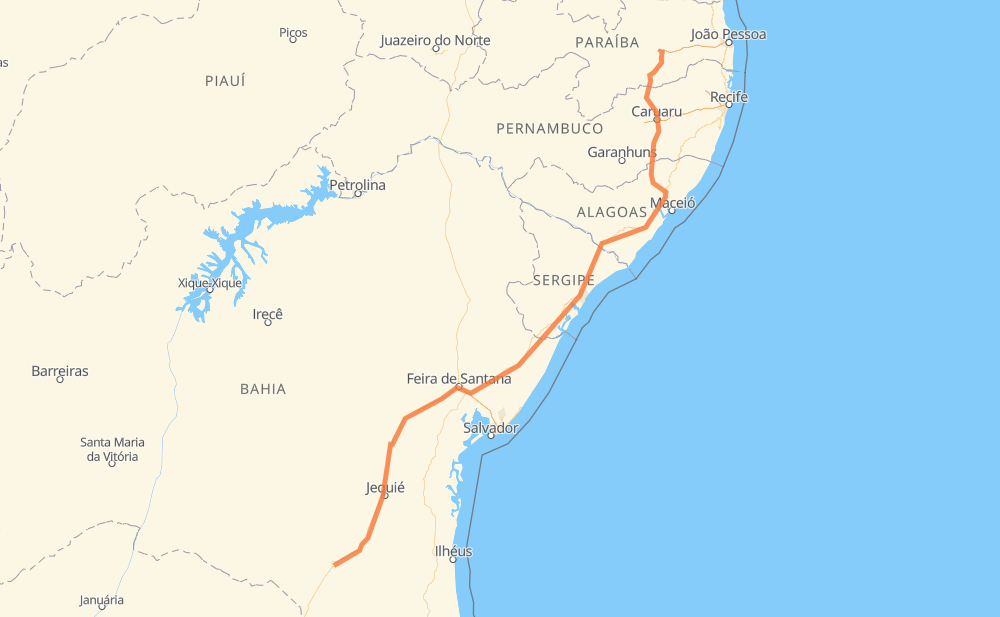
The distance from Felícia to Cidades is 1,279 kilometers by road including 83 kilometers on motorways. Road takes approximately 14 hours and 49 minutes and goes through Nossa Senhora Aparecida, Distrito Industrial dos Imborés, Entrocamento do Cem, Entre Rios, Universitário and Aluízio Campos.
| Shortest distance by air | 1,002 km ✈️ |
| Car route length | 1,279 km 🚗 |
| Driving time | 14 h 49 min |
| Fuel amount | 102.4 L |
| Fuel cost | 182.2 AUD |
| Point | Distance | Time | Fuel | |
| Felícia | 0 km | 00 min | 0.0 L | |
|
BR-116 9 km, 07 min
|
||||
| Nossa Senhora Aparecida | 9 km | 07 min | 0.7 L | |
|
BR-116 3 km, 02 min
|
||||
| Distrito Industrial dos Imborés | 12 km | 09 min | 0.7 L | |
|
BR-116 182 km, 2 h 19 min
|
||||
| Stela Dubois | 195 km | 2 h 29 min | 14.4 L | |
|
BR-116 60 km, 41 min
|
||||
| Entrocamento do Cem | 255 km | 3 h 11 min | 19.8 L | |
|
BR-116 126 km, 1 h 19 min
|
||||
| Santo Estevão Velho | 381 km | 4 h 31 min | 30.3 L | |
|
BR-116 BR-101 149 km, 1 h 40 min
|
||||
| Entre Rios | 530 km | 6 h 11 min | 42.1 L | |
|
BR-101 102 km, 1 h 09 min
|
||||
| Areia Branca | 632 km | 7 h 21 min | 49.9 L | |
|
BR-101 513 km, 5 h 53 min
|
||||
| Universitário | 1,145 km | 13 h 14 min | 91.1 L | |
|
BR-104 125 km, 1 h 26 min
|
||||
| Aluízio Campos | 1,270 km | 14 h 40 min | 101.1 L | |
|
BR-104 BR-230 11 km, 08 min
|
||||
| -7.27935, -35.93228 | 1,280 km | 14 h 49 min | 102.4 L | |
Frequently Asked Questions
How much does it cost to drive from Felícia to Cidades?
Fuel cost: 182.2 AUD
This fuel cost is calculated as: (Route length 1,279 km / 100 km) * (Fuel consumption 8 L/100 km) * (Fuel price 1.78 AUD / L)
You can adjust fuel consumption and fuel price here.
How long is a car ride from Felícia to Cidades?
Driving time: 14 h 49 min
This time is calculated for driving at the maximum permitted speed, taking into account traffic rules restrictions.
- 41 km with a maximum speed 110 km/h = 22 min
- 28 km with a maximum speed 100 km/h = 16 min
- 931 km with a maximum speed 90 km/h = 10 h 20 min
- 209 km with a maximum speed 80 km/h = 2 h 36 min
- 13 km with a maximum speed 70 km/h = 11 min
- 45 km with a maximum speed 60 km/h = 45 min
- 7 km with a maximum speed 50 km/h = 8 min
- 5 km with a maximum speed 40 km/h = 7 min
The calculated driving time does not take into account intermediate stops and traffic jams.
How far is Felícia to Cidades by land?
The distance between Felícia and Cidades is 1,279 km by road including 83 km on motorways.
Precise satellite coordinates of highways were used for this calculation. The start and finish points are the centers of Felícia and Cidades respectively.
How far is Felícia to Cidades by plane?
The shortest distance (air line, as the crow flies) between Felícia and Cidades is 1,002 km.
This distance is calculated using the Haversine formula as a great-circle distance between two points on the surface of a sphere. The start and finish points are the centers of Felícia and Cidades respectively. Actual distance between airports may be different.
How many hours is Felícia from Cidades by plane?
Boeing 737 airliner needs 1 h 15 min to cover the distance of 1,002 km at a cruising speed of 800 km/h.
Small plane "Cessna 172" needs 4 h 33 min to flight this distance at average speed of 220 km/h.
This time is approximate and do not take into account takeoff and landing times, airport location and other real world factors.
How long is a helicopter ride from Felícia to Cidades?
Fast helicopter "Eurocopter AS350" or "Hughes OH-6 Cayuse" need 4 h 10 min to cover the distance of 1,002 km at a cruising speed of 240 km/h.
Popular "Robinson R44" needs 4 h 46 min to flight this distance at average speed of 210 km/h.
This time is approximate and do not take into account takeoff and landing times, aerodrome location and other real world factors.
What city is halfway between Felícia and Cidades?
The halfway point between Felícia and Cidades is Areia Branca. It is located about 8 km from the exact midpoint by road.
The distance from Areia Branca to Felícia is 632 km and driving will take about 7 h 21 min. The road between Areia Branca and Cidades has length 648 km and will take approximately 7 h 28 min.
The other cities located close to halfway point:
Where is Felícia in relation to Cidades?
Felícia is located 1,002 km south-west of Cidades.
Felícia has geographic coordinates: latitude -14.88627, longitude -40.85179.
Cidades has geographic coordinates: latitude -7.27935, longitude -35.93228.
Which highway goes from Felícia to Cidades?
The route from Felícia to Cidades follows BR-101, BR-116, BR-104.
Other minor sections pass along the road:
- BA-262: 35 km
- BR-324: 15 km
- BR-230: 5 km
- BR-030: 3 km