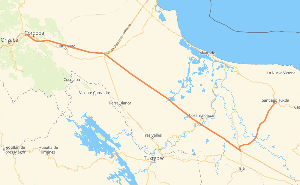
Distance between Fortín de las Flores and Santiago Tuxtla
The distance from Fortín de las Flores to Santiago Tuxtla is 229 kilometers by road including 177 kilometers on motorways. Road takes approximately 2 hours and 24 minutes and goes through Peñuela, El Maguey, Tapalapan and Tecolapan.
| Shortest distance by air | 185 km ✈️ |
| Car route length | 229 km 🚗 |
| Driving time | 2 h 24 min |
| Fuel amount | 18.3 L |
| Fuel cost | 33.2 AUD |
| Toll roads cost | 343 MXN |
| Point | Distance | Time | Fuel | |
| Fortín de las Flores | 0 km | 00 min | 0.0 L | |
|
MEX 125 MEX 150D 14 km, 08 min
|
||||
| Peñuela | 14 km | 08 min | 0.9 L | |
|
MEX 150D 17 km, 09 min
|
||||
| El Maguey | 32 km | 18 min | 2.3 L | |
|
MEX 150D 19 km, 10 min
|
||||
| Cerro Alto | 51 km | 29 min | 3.4 L | |
|
MEX 150D 9 km, 04 min
|
||||
| San Antonio | 60 km | 33 min | 4.8 L | |
|
MEX 150D MEX 145D 4 km, 02 min
|
||||
| Piedra Herrada | 63 km | 36 min | 4.9 L | |
|
MEX 145D 43 km, 26 min
|
||||
| El Barrio | 106 km | 1 h 02 min | 8.4 L | |
|
MEX 145D 39 km, 23 min
|
||||
| Pichoapa | 145 km | 1 h 26 min | 11.5 L | |
|
MEX 145D 48 km, 31 min
|
||||
| Nuevo Viloria | 193 km | 1 h 57 min | 15.3 L | |
|
MEX 179 36 km, 26 min
|
||||
| Santiago Tuxtla | 229 km | 2 h 24 min | 18.3 L | |
Frequently Asked Questions
How many toll booths are there from Fortín de las Flores to Santiago Tuxtla?
There are 2 toll booths between Fortín de las Flores and Santiago Tuxtla: Cuitláhuac and Cosamaloapan.
How much does the toll booths cost from Fortín de las Flores to Santiago Tuxtla?
Toll roads cost: Cuitláhuac (114 MXN) + Cosamaloapan (229 MXN) = 343 MXN
How much does it cost to drive from Fortín de las Flores to Santiago Tuxtla?
Fuel cost: 33.2 AUD
This fuel cost is calculated as: (Route length 229 km / 100 km) * (Fuel consumption 8 L/100 km) * (Fuel price 1.81 AUD / L)
You can adjust fuel consumption and fuel price here.
Toll roads cost: 343 MXN
How long is a car ride from Fortín de las Flores to Santiago Tuxtla?
Driving time: 2 h 24 min
This time is calculated for driving at the maximum permitted speed, taking into account traffic rules restrictions.
- 54 km with a maximum speed 110 km/h = 29 min
- 111 km with a maximum speed 100 km/h = 1 h 6 min
- 3 km with a maximum speed 90 km/h = 2 min
- 60 km with a maximum speed 80 km/h = 44 min
- 2 km with a maximum speed 60 km/h = 1 min
The calculated driving time does not take into account intermediate stops and traffic jams.
How far is Fortín de las Flores to Santiago Tuxtla by land?
The distance between Fortín de las Flores and Santiago Tuxtla is 229 km by road including 177 km on motorways.
Precise satellite coordinates of highways were used for this calculation. The start and finish points are the centers of Fortín de las Flores and Santiago Tuxtla respectively.
How far is Fortín de las Flores to Santiago Tuxtla by plane?
The shortest distance (air line, as the crow flies) between Fortín de las Flores and Santiago Tuxtla is 185 km.
This distance is calculated using the Haversine formula as a great-circle distance between two points on the surface of a sphere. The start and finish points are the centers of Fortín de las Flores and Santiago Tuxtla respectively. Actual distance between airports may be different.
How many hours is Fortín de las Flores from Santiago Tuxtla by plane?
Boeing 737 airliner needs 13 min to cover the distance of 185 km at a cruising speed of 800 km/h.
Small plane "Cessna 172" needs 50 min to flight this distance at average speed of 220 km/h.
This time is approximate and do not take into account takeoff and landing times, airport location and other real world factors.
How long is a helicopter ride from Fortín de las Flores to Santiago Tuxtla?
Fast helicopter "Eurocopter AS350" or "Hughes OH-6 Cayuse" need 46 min to cover the distance of 185 km at a cruising speed of 240 km/h.
Popular "Robinson R44" needs 52 min to flight this distance at average speed of 210 km/h.
This time is approximate and do not take into account takeoff and landing times, aerodrome location and other real world factors.
What city is halfway between Fortín de las Flores and Santiago Tuxtla?
The halfway point between Fortín de las Flores and Santiago Tuxtla is El Barrio. It is located about 9 km from the exact midpoint by road.
The distance from El Barrio to Fortín de las Flores is 106 km and driving will take about 1 h 2 min. The road between El Barrio and Santiago Tuxtla has length 123 km and will take approximately 1 h 21 min.
The other cities located close to halfway point:
Where is Fortín de las Flores in relation to Santiago Tuxtla?
Fortín de las Flores is located 185 km west of Santiago Tuxtla.
Fortín de las Flores has geographic coordinates: latitude 18.89891, longitude -96.99814.
Santiago Tuxtla has geographic coordinates: latitude 18.4654, longitude -95.30241.
Which highway goes from Fortín de las Flores to Santiago Tuxtla?
The route from Fortín de las Flores to Santiago Tuxtla follows MEX 145D.
Other minor sections pass along the road:
- MEX 150D: 57 km
- MEX 179: 49 km