Distance between General Levalle and San Bernardo
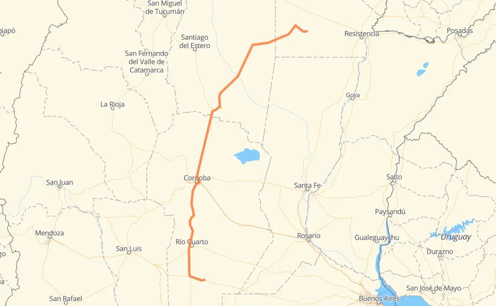
The distance from General Levalle to San Bernardo is 1,053 kilometers by road including 24 kilometers on motorways. Road takes approximately 12 hours and 26 minutes and goes through Río Cuarto, Córdoba, Vicuña Mackenna, Colonia Caroya, Jesús María, Villa del Totoral and Quimilí.
| Shortest distance by air | 808 km ✈️ |
| Car route length | 1,053 km 🚗 |
| Driving time | 12 h 26 min |
| Fuel amount | 84.2 L |
| Fuel cost | 149.9 AUD |
| Point | Distance | Time | Fuel | |
| General Levalle | 0 km | 00 min | 0.0 L | |
|
RP10 RN7 49 km, 33 min
|
||||
| Vicuña Mackenna | 49 km | 33 min | 0.4 L | |
|
RN7 RN35 94 km, 1 h 05 min
|
||||
| Río Cuarto | 144 km | 1 h 39 min | 10.8 L | |
|
RNA005 RN36 222 km, 2 h 29 min
|
||||
| Córdoba | 366 km | 4 h 08 min | 27.4 L | |
|
RNA019 RN9 43 km, 31 min
|
||||
| Colonia Caroya | 409 km | 4 h 39 min | 31.9 L | |
|
RN9 12 km, 08 min
|
||||
| Jesús María | 421 km | 4 h 48 min | 33.6 L | |
|
RN9 27 km, 18 min
|
||||
| Villa del Totoral | 449 km | 5 h 07 min | 35.4 L | |
|
RN9 416 km, 4 h 58 min
|
||||
| Quimilí | 865 km | 10 h 05 min | 60.1 L | |
|
RN89 125 km, 1 h 34 min
|
||||
| General Pinedo | 990 km | 11 h 39 min | 78.2 L | |
|
RN89 63 km, 46 min
|
||||
| San Bernardo | 1,053 km | 12 h 26 min | 80.8 L | |
Frequently Asked Questions
How much does it cost to drive from General Levalle to San Bernardo?
Fuel cost: 149.9 AUD
This fuel cost is calculated as: (Route length 1,053 km / 100 km) * (Fuel consumption 8 L/100 km) * (Fuel price 1.78 AUD / L)
You can adjust fuel consumption and fuel price here.
How long is a car ride from General Levalle to San Bernardo?
Driving time: 12 h 26 min
This time is calculated for driving at the maximum permitted speed, taking into account traffic rules restrictions.
- 23 km with a maximum speed 110 km/h = 12 min
- 530 km with a maximum speed 90 km/h = 5 h 53 min
- 484 km with a maximum speed 80 km/h = 6 h 3 min
- 12 km with a maximum speed 60 km/h = 11 min
- 3 km with a maximum speed 40 km/h = 4 min
The calculated driving time does not take into account intermediate stops and traffic jams.
How far is General Levalle to San Bernardo by land?
The distance between General Levalle and San Bernardo is 1,053 km by road including 24 km on motorways.
Precise satellite coordinates of highways were used for this calculation. The start and finish points are the centers of General Levalle and San Bernardo respectively.
How far is General Levalle to San Bernardo by plane?
The shortest distance (air line, as the crow flies) between General Levalle and San Bernardo is 808 km.
This distance is calculated using the Haversine formula as a great-circle distance between two points on the surface of a sphere. The start and finish points are the centers of General Levalle and San Bernardo respectively. Actual distance between airports may be different.
How many hours is General Levalle from San Bernardo by plane?
Boeing 737 airliner needs 1 h to cover the distance of 808 km at a cruising speed of 800 km/h.
Small plane "Cessna 172" needs 3 h 40 min to flight this distance at average speed of 220 km/h.
This time is approximate and do not take into account takeoff and landing times, airport location and other real world factors.
How long is a helicopter ride from General Levalle to San Bernardo?
Fast helicopter "Eurocopter AS350" or "Hughes OH-6 Cayuse" need 3 h 22 min to cover the distance of 808 km at a cruising speed of 240 km/h.
Popular "Robinson R44" needs 3 h 50 min to flight this distance at average speed of 210 km/h.
This time is approximate and do not take into account takeoff and landing times, aerodrome location and other real world factors.
What city is halfway between General Levalle and San Bernardo?
The halfway point between General Levalle and San Bernardo is Rayo Cortado. It is located about 1 km from the exact midpoint by road.
The distance from Rayo Cortado to General Levalle is 527 km and driving will take about 6 h 2 min. The road between Rayo Cortado and San Bernardo has length 525 km and will take approximately 6 h 23 min.
The other cities located close to halfway point:
Where is General Levalle in relation to San Bernardo?
General Levalle is located 808 km south-west of San Bernardo.
General Levalle has geographic coordinates: latitude -34.0075, longitude -63.92339.
San Bernardo has geographic coordinates: latitude -27.28673, longitude -60.7129.
Which highway goes from General Levalle to San Bernardo?
The route from General Levalle to San Bernardo follows RN9, RN36, RN89, RP92.
Other minor sections pass along the road:
- RN35: 82 km
- RP7: 66 km
- RP1: 48 km
- RN7: 46 km
- RP6: 42 km
- RP13: 37 km
- RNA019: 23 km
- RN2V9: 15 km
- RNA005: 11 km
- RN8: 8 km
- RP10: 4 km