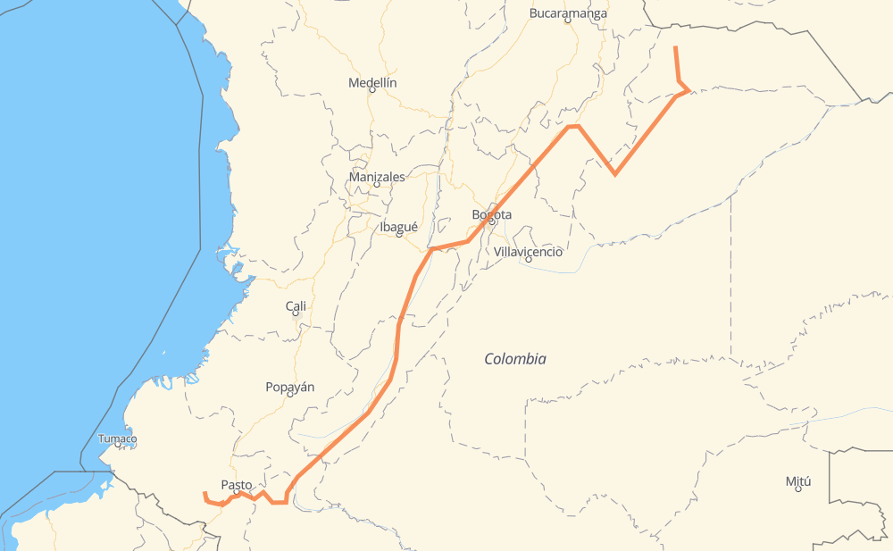
Distance between Guachavés (Santacruz) and Fortul

The distance from Guachavés (Santacruz) to Fortul is 1,457 kilometers by road. Road takes approximately 18 hours and 17 minutes and goes through Pasto, Mocoa, Neiva, Chía, Sogamoso and Yopal.

There are tolls on the route.
Shortest distance by air 901 km ✈️
Car route length 1,457 km 🚗
Driving time 18 h 17 min
Fuel amount 116.6 L
Fuel cost 209.8 AUD
Click here to load the interactive map
Compare this route in other services:
City
Town
Village
Hamlet
Motorway
Primary
Secondary
Unclassified
Point Distance Time Fuel
Guachavés (Santacruz) 0 km 0:00 00 min 0.0 L
17 62 km, 47 min
Ospina 62 km 0:47 47 min 3.9 L
10 25 37 km, 28 min
Yacuanquer 100 km 1:15 1 h 15 min 6.9 L
25 28 km, 21 min
Pasto 128 km 1:37 1 h 37 min 10.1 L
10 50 km, 35 min
Colón 178 km 2:12 2 h 12 min 13.7 L
10 88 km, 1 h 05 min
Mocoa 266 km 3:18 3 h 18 min 20.9 L
45 320 km, 3 h 48 min
Neiva 586 km 7:06 7 h 06 min 46.3 L
45 332 km, 4 h 08 min
Chía 918 km 11:14 11 h 14 min 73.0 L
55 191 km, 2 h 19 min
Sogamoso 1,109 km 13:33 13 h 33 min 87.9 L
62 155 km, 1 h 51 min
Yopal 1,263 km 15:25 15 h 25 min 100.4 L
65 229 km, 2 h 52 min
6.79281, -71.77438 1,493 km 18:17 18 h 17 min 119.4 L
City
Town
Village
Hamlet
Motorway
Primary
Secondary
Unclassified
Point Distance Time Fuel
Guachavés (Santacruz) 0 km 0:00 00 min 0.0 L
17 62 km, 47 min
Ospina 62 km 0:47 47 min 3.9 L
10 25 37 km, 28 min
Yacuanquer 100 km 1:15 1 h 15 min 6.9 L
25 28 km, 21 min
Pasto 128 km 1:37 1 h 37 min 10.1 L
10 11 km, 07 min
La Laguna 139 km 1:45 1 h 45 min 10.5 L
10 40 km, 27 min
Colón 178 km 2:12 2 h 12 min 13.7 L
10 7 km, 04 min
San Pedro 185 km 2:17 2 h 17 min 14.8 L
10 3 km, 02 min
Sibundoy 188 km 2:20 2 h 20 min 14.8 L
10 5 km, 04 min
San Francisco 193 km 2:24 2 h 24 min 15.3 L
10 16 km, 11 min
Siberia 209 km 2:36 2 h 36 min 15.6 L
10 42 km, 29 min
La Tebaida 251 km 3:06 3 h 06 min 19.9 L
10 8 km, 05 min
El Pepino 259 km 3:11 3 h 11 min 20.6 L
45 7 km, 06 min
Mocoa 266 km 3:18 3 h 18 min 20.9 L
45 20 km, 15 min
Fronteriza 286 km 3:34 3 h 34 min 22.6 L
45 38 km, 26 min
San Juan de Villalobos 324 km 4:00 4 h 00 min 25.1 L
45 84 km, 57 min
Pitalito 408 km 4:58 4 h 58 min 31.8 L
45 14 km, 10 min
Timaná 422 km 5:08 5 h 08 min 33.4 L
45 25 km, 18 min
La Jagua 447 km 5:27 5 h 27 min 34.2 L
45 26 km, 18 min
Garzón 473 km 5:46 5 h 46 min 37.7 L
45 28 km, 19 min
Gigante 501 km 6:05 6 h 05 min 39.4 L
45 37 km, 25 min
Hobo 537 km 6:31 6 h 31 min 42.5 L
45 20 km, 14 min
Campoalegre 557 km 6:45 6 h 45 min 44.0 L
45 29 km, 20 min
Neiva 586 km 7:06 7 h 06 min 46.3 L
45 36 km, 25 min
Aipe 622 km 7:31 7 h 31 min 49.3 L
45 40 km, 27 min
Pueblo Nuevo 663 km 7:59 7 h 59 min 52.4 L
45 16 km, 12 min
Natagaima 679 km 8:11 8 h 11 min 53.6 L
45 11 km, 08 min
La Nueva Esperanza 690 km 8:19 8 h 19 min 55.0 L
45 21 km, 14 min
Saldaña 711 km 8:34 8 h 34 min 56.8 L
45 10 km, 07 min
El Guamo 721 km 8:41 8 h 41 min 57.0 L
45 19 km, 13 min
Espinal 740 km 8:55 8 h 55 min 58.8 L
45 38 km, 29 min
Melgar 778 km 9:24 9 h 24 min 61.9 L
40 21 km, 16 min
El Triunfo Boquerón 799 km 9:41 9 h 41 min 63.5 L
40 11 km, 07 min
Chinauta 810 km 9:49 9 h 49 min 64.4 L
40 19 km, 14 min
Silvania 829 km 10:03 10 h 03 min 65.9 L
40 14 km, 10 min
Granada 843 km 10:14 10 h 14 min 66.7 L
40 12 km, 09 min
La Cruz 855 km 10:23 10 h 23 min 68.1 L
40 14 km, 09 min
Soacha 869 km 10:33 10 h 33 min 69.3 L
40 8 km, 05 min
Tunjuelito 877 km 10:39 10 h 39 min 70.1 L
3 km, 02 min
Antonio Nariño 880 km 10:41 10 h 41 min 70.3 L
4 km, 03 min
Puente Aranda 884 km 10:44 10 h 44 min 70.6 L
4 km, 03 min
Teusaquillo 887 km 10:48 10 h 48 min 70.8 L
3 km, 02 min
Barrios Unidos 890 km 10:50 10 h 50 min 71.1 L
12 km, 09 min
Usaquén 902 km 11:00 11 h 00 min 71.3 L
16 km, 13 min
Chía 918 km 11:14 11 h 14 min 73.0 L
55 7 km, 05 min
Hato Grande 925 km 11:19 11 h 19 min 73.9 L
55 4 km, 02 min
Briceño 928 km 11:22 11 h 22 min 74.2 L
55 5 km, 03 min
Tocancipá 933 km 11:25 11 h 25 min 74.5 L
55 7 km, 05 min
Gachancipá 940 km 11:31 11 h 31 min 74.9 L
55 10 km, 07 min
Sesquilé 951 km 11:38 11 h 38 min 75.6 L
55 19 km, 13 min
Chocontá 969 km 11:52 11 h 52 min 76.9 L
55 13 km, 09 min
Villapinzón 983 km 12:02 12 h 02 min 78.3 L
55 20 km, 13 min
Ventaquemada 1,003 km 12:16 12 h 16 min 79.8 L
55 18 km, 13 min
Puente Boyacá 1,021 km 12:29 12 h 29 min 81.1 L
55 9 km, 06 min
Chorro Blanco 1,030 km 12:36 12 h 36 min 82.2 L
55 17 km, 11 min
Oicatá 1,047 km 12:48 12 h 48 min 83.6 L
55 6 km, 04 min
Cómbita 1,053 km 12:52 12 h 52 min 83.9 L
55 12 km, 08 min
Tuta 1,065 km 13:01 13 h 01 min 84.9 L
55 16 km, 11 min
Paipa 1,081 km 13:12 13 h 12 min 86.2 L
55 11 km, 07 min
Duitama 1,093 km 13:20 13 h 20 min 87.3 L
62 16 km, 12 min
Sogamoso 1,109 km 13:33 13 h 33 min 87.9 L
62 13 km, 10 min
El Crucero 1,121 km 13:43 13 h 43 min 89.4 L
62 40 km, 27 min
Toquilla 1,161 km 14:10 14 h 10 min 92.2 L
62 40 km, 27 min
Pajarito 1,201 km 14:38 14 h 38 min 95.5 L
62 12 km, 08 min
Monterralo 1,212 km 14:47 14 h 47 min 96.6 L
62 7 km, 05 min
Cupiagua 1,220 km 14:52 14 h 52 min 97.4 L
62 7 km, 05 min
Unete 1,227 km 14:58 14 h 58 min 97.8 L
62 10 km, 07 min
Aguazul 1,237 km 15:05 15 h 05 min 98.5 L
65 27 km, 18 min
Yopal 1,264 km 15:24 15 h 24 min 100.4 L
65 33 km, 22 min
La yopaloza 1,296 km 15:47 15 h 47 min 103.5 L
65 55 km, 36 min
Paz de Ariporo 1,351 km 16:23 16 h 23 min 107.7 L
65 73 km, 52 min
El Susto 1,424 km 17:16 17 h 16 min 113.8 L
7 km, 07 min
Casablanca 1,431 km 17:24 17 h 24 min 114.0 L
14 km, 14 min
Tame 1,445 km 17:38 17 h 38 min 115.2 L
65 19 km, 15 min
Tamacay 1,464 km 17:53 17 h 53 min 116.6 L
65 11 km, 08 min
El Mordisco 1,475 km 18:02 18 h 02 min 117.7 L
65 10 km, 07 min
Palmarito 1,485 km 18:09 18 h 09 min 118.3 L
65 8 km, 07 min
6.79281, -71.77438 1,493 km 18:16 18 h 16 min 119.4 L

Frequently Asked Questions

How much does it cost to drive from Guachavés (Santacruz) to Fortul?

Fuel cost: 209.8 AUD

This fuel cost is calculated as: (Route length 1,457 km / 100 km) * (Fuel consumption 8 L/100 km) * (Fuel price 1.8 AUD / L)

You can adjust fuel consumption and fuel price here.

How long is a car ride from Guachavés (Santacruz) to Fortul?

Driving time: 18 h 17 min

This time is calculated for driving at the maximum permitted speed, taking into account traffic rules restrictions.

  • 591 km with a maximum speed 90 km/h = 6 h 34 min
  • 836 km with a maximum speed 80 km/h = 10 h 26 min
  • 28 km with a maximum speed 60 km/h = 27 min
  • 32 km with a maximum speed 50 km/h = 38 min
  • 5 km with a maximum speed 30 km/h = 9 min

The calculated driving time does not take into account intermediate stops and traffic jams.

How far is Guachavés (Santacruz) to Fortul by land?

The distance between Guachavés (Santacruz) and Fortul is 1,457 km by road.

Precise satellite coordinates of highways were used for this calculation. The start and finish points are the centers of Guachavés (Santacruz) and Fortul respectively.

How far is Guachavés (Santacruz) to Fortul by plane?

The shortest distance (air line, as the crow flies) between Guachavés (Santacruz) and Fortul is 901 km.

This distance is calculated using the Haversine formula as a great-circle distance between two points on the surface of a sphere. The start and finish points are the centers of Guachavés (Santacruz) and Fortul respectively. Actual distance between airports may be different.

How many hours is Guachavés (Santacruz) from Fortul by plane?

Boeing 737 airliner needs 1 h 7 min to cover the distance of 901 km at a cruising speed of 800 km/h.

Small plane "Cessna 172" needs 4 h 5 min to flight this distance at average speed of 220 km/h.

This time is approximate and do not take into account takeoff and landing times, airport location and other real world factors.

How long is a helicopter ride from Guachavés (Santacruz) to Fortul?

Fast helicopter "Eurocopter AS350" or "Hughes OH-6 Cayuse" need 3 h 45 min to cover the distance of 901 km at a cruising speed of 240 km/h.

Popular "Robinson R44" needs 4 h 17 min to flight this distance at average speed of 210 km/h.

This time is approximate and do not take into account takeoff and landing times, aerodrome location and other real world factors.

What city is halfway between Guachavés (Santacruz) and Fortul?

The halfway point between Guachavés (Santacruz) and Fortul is El Guamo. It is located about 7 km from the exact midpoint by road.

The distance from El Guamo to Guachavés (Santacruz) is 721 km and driving will take about 8 h 41 min. The road between El Guamo and Fortul has length 736 km and will take approximately 9 h 36 min.

The other cities located close to halfway point:

  • Espinal is in 740 km from Guachavés (Santacruz) and 717 km from Fortul
  • Saldaña is in 711 km from Guachavés (Santacruz) and 746 km from Fortul
  • La Nueva Esperanza is in 690 km from Guachavés (Santacruz) and 767 km from Fortul

Where is Guachavés (Santacruz) in relation to Fortul?

Guachavés (Santacruz) is located 901 km south-west of Fortul.

Guachavés (Santacruz) has geographic coordinates: latitude 1.22164, longitude -77.67723.

Fortul has geographic coordinates: latitude 6.79281, longitude -71.77438.

Which highway goes from Guachavés (Santacruz) to Fortul?

The route from Guachavés (Santacruz) to Fortul follows 45, 65, 55, 10, 62, 40.

Other minor sections pass along the road:

  • 25: 42 km
  • 17: 35 km
The distance between Guachavés (Santacruz) and Fortul is ranked 28,639th in the ranking popularity.
Have any questions? Contact us!