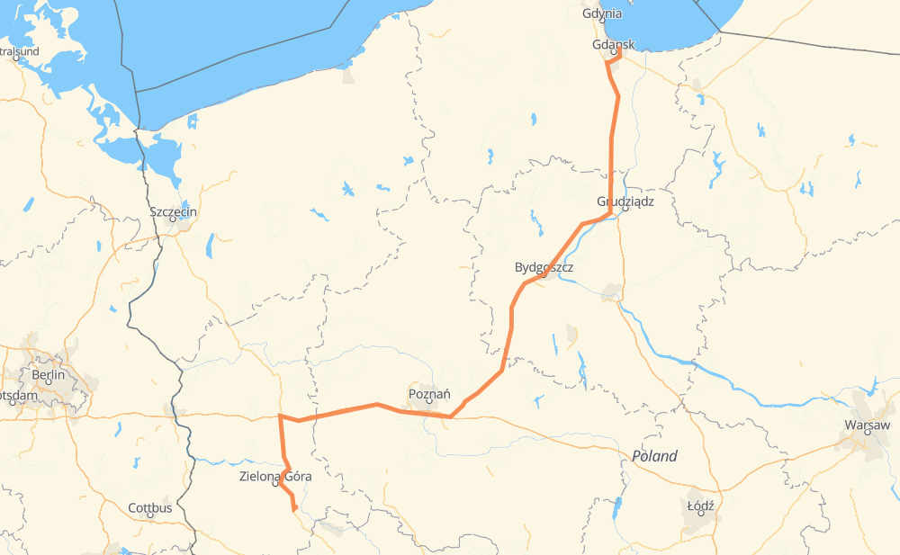
The distance from Heubude to Neusalz an der Oder is 475 kilometers by road including 204 kilometers on motorways. Road takes approximately 5 hours and 15 minutes and goes through Bromberg, Grünberg in Schlesien, Orunia - Święty Wojciech - Lipce, Praust, Schwetz an der Weichsel, Błonie and Schubin.
How much does it cost to drive from Heubude to Neusalz an der Oder?
Fuel cost:
67.7 AUD
This fuel cost is calculated as: (Route length 475 km / 100 km) * (Fuel consumption 8 L/100 km) * (Fuel price 1.78 AUD / L)
You can adjust fuel consumption and fuel price here.
How long is a car ride from Heubude to Neusalz an der Oder?
Driving time:
5 h 15 min
This time is calculated for driving at the maximum permitted speed, taking into account traffic rules restrictions.
198 km with a maximum speed 110 km/h = 1 h 47 min
215 km with a maximum speed 90 km/h = 2 h 23 min
9 km with a maximum speed 80 km/h = 6 min
26 km with a maximum speed 70 km/h = 22 min
23 km with a maximum speed 50 km/h = 27 min
3 km with a maximum speed 40 km/h = 4 min
1 km with a maximum speed 20 km/h = 2 min
The calculated driving time does not take into account intermediate stops and traffic jams.
How far is Heubude to Neusalz an der Oder by land?
The distance between Heubude and Neusalz an der Oder is 475 km by road including 204 km on motorways.
Precise satellite coordinates of highways were used for this calculation. The start and finish points are the centers of Heubude and Neusalz an der Oder respectively.
How far is Heubude to Neusalz an der Oder by plane?
The shortest distance (air line, as the crow flies) between Heubude and Neusalz an der Oder is 349 km.
This distance is calculated using the Haversine formula as a great-circle distance between two points on the surface of a sphere. The start and finish points are the centers of Heubude and Neusalz an der Oder respectively. Actual distance between airports may be different.
How many hours is Heubude from Neusalz an der Oder by plane?
Boeing 737 airliner needs 26 min to cover the distance of 349 km at a cruising speed of 800 km/h.
Small plane "Cessna 172" needs 1 h 35 min to flight this distance at average speed of 220 km/h.
This time is approximate and do not take into account takeoff and landing times, airport location and other real world factors.
How long is a helicopter ride from Heubude to Neusalz an der Oder?
Fast helicopter "Eurocopter AS350" or "Hughes OH-6 Cayuse" need 1 h 27 min to cover the distance of 349 km at a cruising speed of 240 km/h.
Popular "Robinson R44" needs 1 h 39 min to flight this distance at average speed of 210 km/h.
This time is approximate and do not take into account takeoff and landing times, aerodrome location and other real world factors.
What city is halfway between Heubude and Neusalz an der Oder?
The halfway point between Heubude and Neusalz an der Oder is Ostrów. It is located about 2 km from the exact midpoint by road.
The distance from Ostrów to Heubude is 236 km and driving will take about 2 h 44 min. The road between Ostrów and Neusalz an der Oder has length 240 km and will take approximately 2 h 30 min.
The other cities located close to halfway point:
Łaziska is in 231 km from Heubude and 245 km from Neusalz an der Oder
Łabiszynek is in 245 km from Heubude and 230 km from Neusalz an der Oder
Krzyszczewo is in 250 km from Heubude and 225 km from Neusalz an der Oder
Where is Heubude in relation to Neusalz an der Oder?
Heubude is located 349 km north-east of Neusalz an der Oder.
Heubude has geographic coordinates: latitude 54.3739, longitude 18.70311.
Neusalz an der Oder has geographic coordinates: latitude 51.80325, longitude 15.71194.
Which highway goes from Heubude to Neusalz an der Oder?
The route from Heubude to Neusalz an der Oder follows A2, S5.