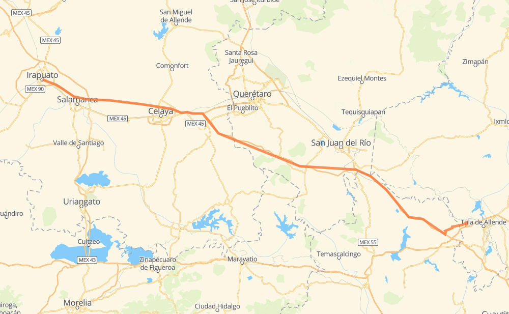
Distance between Irapuato and Xochitlán de las Flores
The distance from Irapuato to Xochitlán de las Flores is 234 kilometers by road including 212 kilometers on motorways. Road takes approximately 2 hours and 21 minutes and goes through Salamanca, Celaya, Cárdenas and Apaseo el Grande.
| Shortest distance by air | 213 km ✈️ |
| Car route length | 234 km 🚗 |
| Driving time | 2 h 21 min |
| Fuel amount | 18.7 L |
| Fuel cost | 33.3 AUD |
| Toll roads cost | 172 + ? MXN |
| Point | Distance | Time | Fuel | |
| Irapuato | 0 km | 00 min | 0.0 L | |
|
MEX 45D 14 km, 10 min
|
||||
| Cárdenas | 14 km | 10 min | 0.8 L | |
|
MEX 45D 8 km, 06 min
|
||||
| Salamanca | 22 km | 16 min | 1.4 L | |
|
MEX 45D 6 km, 04 min
|
||||
| Cerro Gordo | 28 km | 20 min | 2.1 L | |
|
MEX 45D 30 km, 18 min
|
||||
| Celaya | 58 km | 38 min | 4.3 L | |
|
MEX 45D 15 km, 08 min
|
||||
| Apaseo el Grande | 73 km | 47 min | 5.6 L | |
|
MEX 45D MEX 47D 31 km, 17 min
|
||||
| El Jaral | 104 km | 1 h 04 min | 8.2 L | |
|
MEX 47D 55 km, 30 min
|
||||
| Santa Bárbara de la Cueva | 160 km | 1 h 34 min | 12.6 L | |
|
MEX 47D MEX 57D 74 km, 46 min
|
||||
| Xochitlán de las Flores | 234 km | 2 h 21 min | 18.6 L | |
Frequently Asked Questions
How many toll booths are there from Irapuato to Xochitlán de las Flores?
There are 4 toll booths between Irapuato and Xochitlán de las Flores: Salamanca, Cerro Gordo, Palmillas and Palmilas - Apaseo.
How much does the toll booths cost from Irapuato to Xochitlán de las Flores?
Toll roads cost: Salamanca (83 MXN) + Cerro Gordo (?) + Palmilas - Apaseo (?) + Palmillas (89 MXN) = 172 + ? MXN
How much does it cost to drive from Irapuato to Xochitlán de las Flores?
Fuel cost: 33.3 AUD
This fuel cost is calculated as: (Route length 234 km / 100 km) * (Fuel consumption 8 L/100 km) * (Fuel price 1.78 AUD / L)
You can adjust fuel consumption and fuel price here.
Toll roads cost: 172 + ? MXN
How long is a car ride from Irapuato to Xochitlán de las Flores?
Driving time: 2 h 21 min
This time is calculated for driving at the maximum permitted speed, taking into account traffic rules restrictions.
- 128 km with a maximum speed 110 km/h = 1 h 9 min
- 57 km with a maximum speed 100 km/h = 33 min
- 19 km with a maximum speed 90 km/h = 12 min
- 27 km with a maximum speed 80 km/h = 19 min
- 3 km with a maximum speed 50 km/h = 3 min
- 1 km with a maximum speed 40 km/h = 1 min
The calculated driving time does not take into account intermediate stops and traffic jams.
How far is Irapuato to Xochitlán de las Flores by land?
The distance between Irapuato and Xochitlán de las Flores is 234 km by road including 212 km on motorways.
Precise satellite coordinates of highways were used for this calculation. The start and finish points are the centers of Irapuato and Xochitlán de las Flores respectively.
How far is Irapuato to Xochitlán de las Flores by plane?
The shortest distance (air line, as the crow flies) between Irapuato and Xochitlán de las Flores is 213 km.
This distance is calculated using the Haversine formula as a great-circle distance between two points on the surface of a sphere. The start and finish points are the centers of Irapuato and Xochitlán de las Flores respectively. Actual distance between airports may be different.
How many hours is Irapuato from Xochitlán de las Flores by plane?
Boeing 737 airliner needs 15 min to cover the distance of 213 km at a cruising speed of 800 km/h.
Small plane "Cessna 172" needs 58 min to flight this distance at average speed of 220 km/h.
This time is approximate and do not take into account takeoff and landing times, airport location and other real world factors.
How long is a helicopter ride from Irapuato to Xochitlán de las Flores?
Fast helicopter "Eurocopter AS350" or "Hughes OH-6 Cayuse" need 53 min to cover the distance of 213 km at a cruising speed of 240 km/h.
Popular "Robinson R44" needs 1 h to flight this distance at average speed of 210 km/h.
This time is approximate and do not take into account takeoff and landing times, aerodrome location and other real world factors.
What city is halfway between Irapuato and Xochitlán de las Flores?
The halfway point between Irapuato and Xochitlán de las Flores is El Jaral. It is located about 13 km from the exact midpoint by road.
The distance from El Jaral to Irapuato is 104 km and driving will take about 1 h 4 min. The road between El Jaral and Xochitlán de las Flores has length 130 km and will take approximately 1 h 16 min.
Where is Irapuato in relation to Xochitlán de las Flores?
Irapuato is located 213 km north-west of Xochitlán de las Flores.
Irapuato has geographic coordinates: latitude 20.67588, longitude -101.35211.
Xochitlán de las Flores has geographic coordinates: latitude 20.05305, longitude -99.42194.
Which highway goes from Irapuato to Xochitlán de las Flores?
The route from Irapuato to Xochitlán de las Flores follows MEX 47D, MEX 45D.
Other minor sections pass along the road:
- MEX 57D: 54 km
- MEX 661: 4 km