Distance between Jarudore and Mato Grosso
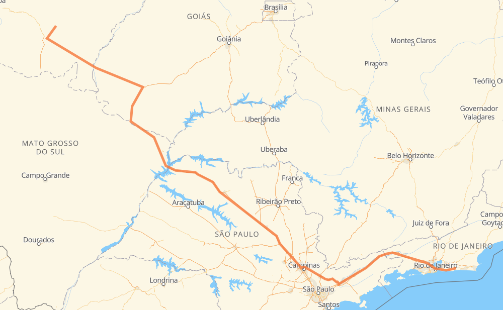
The distance from Jarudore to Mato Grosso is 1,893 kilometers by road including 1,050 kilometers on motorways. Road takes approximately 20 hours and 14 minutes and goes through Rondonopolis, Rio Claro, Itatiba, Atibaia, Jacareí, Guaratinguetá and Niterói.
| Shortest distance by air | 1,432 km ✈️ |
| Car route length | 1,893 km 🚗 |
| Driving time | 20 h 14 min |
| Fuel amount | 151.5 L |
| Fuel cost | 272.7 AUD |
| Point | Distance | Time | Fuel | |
| Vila Jarudore | 0 km | 00 min | 0.0 L | |
|
MT-458 MT-130 51 km, 37 min
|
||||
| Anézio Pereira de Oliveira | 51 km | 37 min | 3.7 L | |
|
MT-130 10 km, 08 min
|
||||
| Rondonopolis | 61 km | 46 min | 4.9 L | |
|
MT-383 BR-364 1,187 km, 12 h 32 min
|
||||
| Rio Claro | 1,249 km | 13 h 18 min | 99.5 L | |
|
SP-310 SP-330 113 km, 1 h 07 min
|
||||
| Itatiba | 1,362 km | 14 h 26 min | 108.5 L | |
|
SP-065 26 km, 14 min
|
||||
| Atibaia | 1,388 km | 14 h 40 min | 110.0 L | |
|
SP-065 80 km, 46 min
|
||||
| Jacareí | 1,468 km | 15 h 27 min | 117.2 L | |
|
SP-060 BR-116 99 km, 58 min
|
||||
| Guaratinguetá | 1,567 km | 16 h 25 min | 125.1 L | |
|
SP-060 BR-116 263 km, 2 h 55 min
|
||||
| Niterói | 1,830 km | 19 h 20 min | 145.8 L | |
|
BR-101 RJ-104 14 km, 11 min
|
||||
| São Gonçalo | 1,844 km | 19 h 32 min | 147.1 L | |
|
RJ-106 51 km, 41 min
|
||||
| -22.88028, -42.61480 | 1,894 km | 20 h 14 min | 151.6 L | |
Hotels of Mato Grosso
Frequently Asked Questions
How much does it cost to drive from Jarudore to Mato Grosso?
Fuel cost: 272.7 AUD
This fuel cost is calculated as: (Route length 1,893 km / 100 km) * (Fuel consumption 8 L/100 km) * (Fuel price 1.8 AUD / L)
You can adjust fuel consumption and fuel price here.
How long is a car ride from Jarudore to Mato Grosso?
Driving time: 20 h 14 min
This time is calculated for driving at the maximum permitted speed, taking into account traffic rules restrictions.
- 685 km with a maximum speed 110 km/h = 6 h 13 min
- 217 km with a maximum speed 100 km/h = 2 h 9 min
- 785 km with a maximum speed 90 km/h = 8 h 43 min
- 111 km with a maximum speed 80 km/h = 1 h 23 min
- 31 km with a maximum speed 70 km/h = 26 min
- 37 km with a maximum speed 60 km/h = 37 min
- 8 km with a maximum speed 50 km/h = 9 min
- 21 km with a maximum speed 40 km/h = 31 min
The calculated driving time does not take into account intermediate stops and traffic jams.
How far is Jarudore to Mato Grosso by land?
The distance between Jarudore and Mato Grosso is 1,893 km by road including 1,050 km on motorways.
Precise satellite coordinates of highways were used for this calculation. The start and finish points are the centers of Jarudore and Mato Grosso respectively.
How far is Jarudore to Mato Grosso by plane?
The shortest distance (air line, as the crow flies) between Jarudore and Mato Grosso is 1,432 km.
This distance is calculated using the Haversine formula as a great-circle distance between two points on the surface of a sphere. The start and finish points are the centers of Jarudore and Mato Grosso respectively. Actual distance between airports may be different.
How many hours is Jarudore from Mato Grosso by plane?
Boeing 737 airliner needs 1 h 47 min to cover the distance of 1,432 km at a cruising speed of 800 km/h.
Small plane "Cessna 172" needs 6 h 30 min to flight this distance at average speed of 220 km/h.
This time is approximate and do not take into account takeoff and landing times, airport location and other real world factors.
How long is a helicopter ride from Jarudore to Mato Grosso?
Fast helicopter "Eurocopter AS350" or "Hughes OH-6 Cayuse" need 5 h 58 min to cover the distance of 1,432 km at a cruising speed of 240 km/h.
Popular "Robinson R44" needs 6 h 49 min to flight this distance at average speed of 210 km/h.
This time is approximate and do not take into account takeoff and landing times, aerodrome location and other real world factors.
What city is halfway between Jarudore and Mato Grosso?
The halfway point between Jarudore and Mato Grosso is Jardim Santa Mônica. It is located about 2 km from the exact midpoint by road.
The distance from Jardim Santa Mônica to Jarudore is 945 km and driving will take about 10 h 19 min. The road between Jardim Santa Mônica and Mato Grosso has length 948 km and will take approximately 9 h 54 min.
The other cities located close to halfway point:
Where is Jarudore in relation to Mato Grosso?
Jarudore is located 1,432 km north-west of Mato Grosso.
Jarudore has geographic coordinates: latitude -16.2012, longitude -54.30491.
Mato Grosso has geographic coordinates: latitude -22.88028, longitude -42.6148.
Which highway goes from Jarudore to Mato Grosso?
The route from Jarudore to Mato Grosso follows BR-364, BR-116, SP-310, SP-320, SP-060, GO-184, BR-158, SP-065.
Other minor sections pass along the road:
- BR-060: 81 km
- BR-267: 59 km
- RJ-106: 52 km
- SP-330: 49 km
- BR-050: 49 km
- MT-130: 32 km
- GO-302: 27 km
- BR-101: 27 km
- BR-459: 14 km
- BR-383: 11 km
- RJ-104: 10 km
- MT-100: 7 km
- KM-272: 3 km
- MT-383: 3 km
- BR-436: 2 km
- MT-458: 1 km