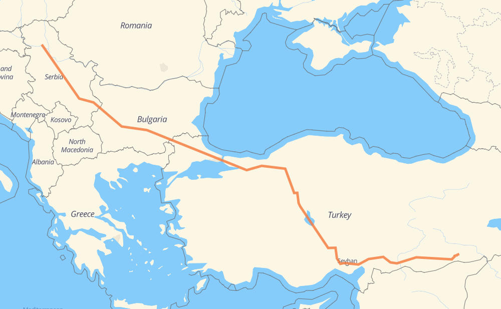
Distance between Kac and Ömerli
The distance from Kac to Ömerli is 2,530 kilometers by road including 1,952 kilometers on motorways. Road takes approximately 26 hours and 57 minutes and goes through Belgrade, Nis, Sofia, Pazardzhik, Dimitrovgrad, Haskovo and Edirne.
| Shortest distance by air | 1,954 km ✈️ |
| Car route length | 2,530 km 🚗 |
| Driving time | 26 h 57 min |
| Fuel amount | 202.4 L |
| Fuel cost | 364.3 AUD |
| Point | Distance | Time | Fuel | |
| Kac | 0 km | 00 min | 0.0 L | |
|
129 A1 92 km, 59 min
|
||||
| Belgrade | 92 km | 59 min | 4.3 L | |
|
A1 227 km, 2 h 06 min
|
||||
| Nis | 319 km | 3 h 05 min | 25.4 L | |
|
A4 152 km, 1 h 35 min
|
||||
| Sofia | 471 km | 4 h 41 min | 37.2 L | |
|
8 A 1 122 km, 1 h 10 min
|
||||
| Pazardzhik | 593 km | 5 h 51 min | 45.9 L | |
|
A 1 99 km, 54 min
|
||||
| Dimitrovgrad | 692 km | 6 h 46 min | 54.0 L | |
|
A 4 16 km, 08 min
|
||||
| Haskovo | 708 km | 6 h 54 min | 56.7 L | |
|
A 4 87 km, 53 min
|
||||
| Edirne | 796 km | 7 h 48 min | 63.2 L | |
|
O-3 O-52 1,737 km, 18 h 51 min
|
||||
| Mardin | 2,532 km | 26 h 39 min | 202.6 L | |
|
D380 25 km, 17 min
|
||||
| Şafak Mah. | 2,557 km | 26 h 57 min | 204.6 L | |
Frequently Asked Questions
How much does it cost to drive from Kac to Ömerli?
Fuel cost: 364.3 AUD
This fuel cost is calculated as: (Route length 2,530 km / 100 km) * (Fuel consumption 8 L/100 km) * (Fuel price 1.8 AUD / L)
You can adjust fuel consumption and fuel price here.
How long is a car ride from Kac to Ömerli?
Driving time: 26 h 57 min
This time is calculated for driving at the maximum permitted speed, taking into account traffic rules restrictions.
- 1,034 km with a maximum speed 110 km/h = 9 h 24 min
- 528 km with a maximum speed 100 km/h = 5 h 16 min
- 261 km with a maximum speed 90 km/h = 2 h 53 min
- 699 km with a maximum speed 80 km/h = 8 h 44 min
- 13 km with a maximum speed 70 km/h = 10 min
- 7 km with a maximum speed 60 km/h = 6 min
- 12 km with a maximum speed 50 km/h = 14 min
- 3 km with a maximum speed 40 km/h = 5 min
The calculated driving time does not take into account intermediate stops and traffic jams.
How far is Kac to Ömerli by land?
The distance between Kac and Ömerli is 2,530 km by road including 1,952 km on motorways.
Precise satellite coordinates of highways were used for this calculation. The start and finish points are the centers of Kac and Ömerli respectively.
How far is Kac to Ömerli by plane?
The shortest distance (air line, as the crow flies) between Kac and Ömerli is 1,954 km.
This distance is calculated using the Haversine formula as a great-circle distance between two points on the surface of a sphere. The start and finish points are the centers of Kac and Ömerli respectively. Actual distance between airports may be different.
How many hours is Kac from Ömerli by plane?
Boeing 737 airliner needs 2 h 26 min to cover the distance of 1,954 km at a cruising speed of 800 km/h.
Small plane "Cessna 172" needs 8 h 52 min to flight this distance at average speed of 220 km/h.
This time is approximate and do not take into account takeoff and landing times, airport location and other real world factors.
How long is a helicopter ride from Kac to Ömerli?
Fast helicopter "Eurocopter AS350" or "Hughes OH-6 Cayuse" need 8 h 8 min to cover the distance of 1,954 km at a cruising speed of 240 km/h.
Popular "Robinson R44" needs 9 h 18 min to flight this distance at average speed of 210 km/h.
This time is approximate and do not take into account takeoff and landing times, aerodrome location and other real world factors.
What city is halfway between Kac and Ömerli?
The halfway point between Kac and Ömerli is Kaynaşlı. It is located about 2 km from the exact midpoint by road.
The distance from Kaynaşlı to Kac is 1,263 km and driving will take about 12 h 27 min. The road between Kaynaşlı and Ömerli has length 1,267 km and will take approximately 14 h 30 min.
The other cities located close to halfway point:
Where is Kac in relation to Ömerli?
Kac is located 1,954 km north-west of Ömerli.
Kac has geographic coordinates: latitude 45.30499, longitude 19.93949.
Ömerli has geographic coordinates: latitude 37.40194, longitude 40.95517.
Which highway goes from Kac to Ömerli?
The route from Kac to Ömerli follows O-52, O-4, A1, D750, O-3, A 1, A 4, A4.
Other minor sections pass along the road:
- O-21: 98 km
- O-7: 76 km
- 8: 60 km
- D950: 46 km
- O-20: 40 km
- O-51: 30 km
- O-21A: 29 km
- O-2: 28 km
- D380: 24 km
- D400: 15 km
- A 6: 14 km
- 18: 13 km
- D100: 10 km
- 6: 8 km
- 1: 8 km
- 129: 7 km
- Kuzey Marmara Otoyolu: 4 km
- O-6: 3 km
- 158: 1 km