Distance between Kimball Junction UT and Bridgeport CT
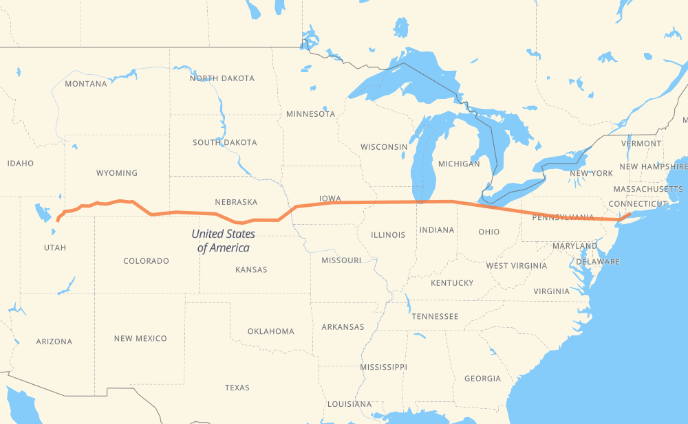
The distance from Kimball Junction to Bridgeport is 3,540 kilometers by road including 3,528 kilometers on motorways. Road takes approximately 32 hours and 58 minutes and goes through Rock Springs, Laramie, Cheyenne, North Platte, Lincoln, Omaha and Iowa City.
How much does it cost to drive from Kimball Junction to Bridgeport?
Fuel cost:
509.7 AUD
This fuel cost is calculated as: (Route length 3,540 km / 100 km) * (Fuel consumption 8 L/100 km) * (Fuel price 1.8 AUD / L)
You can adjust fuel consumption and fuel price here.
How long is a car ride from Kimball Junction to Bridgeport?
Driving time:
32 h 58 min
This time is calculated for driving at the maximum permitted speed, taking into account traffic rules restrictions.
2,997 km with a maximum speed 110 km/h = 27 h 14 min
276 km with a maximum speed 105 km/h = 2 h 38 min
27 km with a maximum speed 100 km/h = 15 min
7 km with a maximum speed 97 km/h = 4 min
142 km with a maximum speed 89 km/h = 1 h 36 min
16 km with a maximum speed 80 km/h = 12 min
73 km with a maximum speed 80 km/h = 55 min
1 km with a maximum speed 64 km/h = 1 min
The calculated driving time does not take into account intermediate stops and traffic jams.
How far is Kimball Junction to Bridgeport by land?
The distance between Kimball Junction and Bridgeport is 3,540 km by road including 3,528 km on motorways.
Precise satellite coordinates of highways were used for this calculation. The start and finish points are the centers of Kimball Junction and Bridgeport respectively.
How far is Kimball Junction to Bridgeport by plane?
The shortest distance (air line, as the crow flies) between Kimball Junction and Bridgeport is 3,195 km.
This distance is calculated using the Haversine formula as a great-circle distance between two points on the surface of a sphere. The start and finish points are the centers of Kimball Junction and Bridgeport respectively. Actual distance between airports may be different.
How many hours is Kimball Junction from Bridgeport by plane?
Boeing 737 airliner needs 3 h 59 min to cover the distance of 3,195 km at a cruising speed of 800 km/h.
Small plane "Cessna 172" needs 14 h 31 min to flight this distance at average speed of 220 km/h.
This time is approximate and do not take into account takeoff and landing times, airport location and other real world factors.
How long is a helicopter ride from Kimball Junction to Bridgeport?
Fast helicopter "Eurocopter AS350" or "Hughes OH-6 Cayuse" need 13 h 18 min to cover the distance of 3,195 km at a cruising speed of 240 km/h.
Popular "Robinson R44" needs 15 h 12 min to flight this distance at average speed of 210 km/h.
This time is approximate and do not take into account takeoff and landing times, aerodrome location and other real world factors.
What city is halfway between Kimball Junction and Bridgeport?
The halfway point between Kimball Junction and Bridgeport is Gonoa Bluff. It is located about 39 km from the exact midpoint by road.
The distance from Gonoa Bluff to Kimball Junction is 1,809 km and driving will take about 16 h 32 min. The road between Gonoa Bluff and Bridgeport has length 1,731 km and will take approximately 16 h 26 min.
The other cities located close to halfway point:
Newton is in 1,729 km from Kimball Junction and 1,811 km from Bridgeport
Parkview Mobile Home Park is in 1,837 km from Kimball Junction and 1,703 km from Bridgeport
Coralville is in 1,849 km from Kimball Junction and 1,691 km from Bridgeport
Where is Kimball Junction in relation to Bridgeport?
Kimball Junction is located 3,195 km west of Bridgeport.
Kimball Junction has geographic coordinates: latitude 40.72717, longitude -111.54409.
Bridgeport has geographic coordinates: latitude 41.16704, longitude -73.20483.
Which highway goes from Kimball Junction to Bridgeport?
The route from Kimball Junction to Bridgeport follows I 80, I 90, US 30, US 6, US 189.