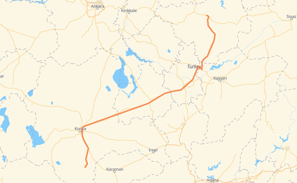
Distance between Koçaş and Sorgun
The distance from Koçaş to Sorgun is 479 kilometers by road. Road takes approximately 5 hours and 50 minutes and goes through Kaşınhanı İstasyon Mah., Taşra Karaslandede Mah., Fevzi Çakmak Mah., Büyükkayacık Mah., Acıgöl, Aktepe and Boğazlıyan.
| Shortest distance by air | 364 km ✈️ |
| Car route length | 479 km 🚗 |
| Driving time | 5 h 50 min |
| Fuel amount | 38.3 L |
| Fuel cost | 68.6 AUD |
| Point | Distance | Time | Fuel | |
| 37.24510, 32.58085 | 0 km | 00 min | 0.0 L | |
|
9 km, 06 min
|
||||
| Dinek | 9 km | 06 min | 0.1 L | |
|
D705 46 km, 34 min
|
||||
| Kaşınhanı İstasyon Mah. | 56 km | 41 min | 3.6 L | |
|
D715 14 km, 10 min
|
||||
| Taşra Karaslandede Mah. | 70 km | 52 min | 5.4 L | |
|
D715 15 km, 10 min
|
||||
| Fevzi Çakmak Mah. | 85 km | 1 h 02 min | 6.6 L | |
|
D715 4 km, 03 min
|
||||
| Büyükkayacık Mah. | 89 km | 1 h 05 min | 7.2 L | |
|
D715 D300 191 km, 2 h 20 min
|
||||
| Acıgöl | 280 km | 3 h 26 min | 22.1 L | |
|
D300 40 km, 27 min
|
||||
| Aktepe | 320 km | 3 h 53 min | 25.5 L | |
|
D300 50-01 78 km, 55 min
|
||||
| Boğazlıyan | 397 km | 4 h 48 min | 31.6 L | |
|
D805 55 km, 40 min
|
||||
| Sarıkaya | 452 km | 5 h 29 min | 34.5 L | |
|
D805 28 km, 20 min
|
||||
| Sorgun | 479 km | 5 h 49 min | 37.9 L | |
Hotels of Sorgun
Frequently Asked Questions
How much does it cost to drive from Koçaş to Sorgun?
Fuel cost: 68.6 AUD
This fuel cost is calculated as: (Route length 479 km / 100 km) * (Fuel consumption 8 L/100 km) * (Fuel price 1.79 AUD / L)
You can adjust fuel consumption and fuel price here.
How long is a car ride from Koçaş to Sorgun?
Driving time: 5 h 50 min
This time is calculated for driving at the maximum permitted speed, taking into account traffic rules restrictions.
- 131 km with a maximum speed 90 km/h = 1 h 27 min
- 338 km with a maximum speed 80 km/h = 4 h 13 min
- 9 km with a maximum speed 70 km/h = 7 min
The calculated driving time does not take into account intermediate stops and traffic jams.
How far is Koçaş to Sorgun by land?
The distance between Koçaş and Sorgun is 479 km by road.
Precise satellite coordinates of highways were used for this calculation. The start and finish points are the centers of Koçaş and Sorgun respectively.
How far is Koçaş to Sorgun by plane?
The shortest distance (air line, as the crow flies) between Koçaş and Sorgun is 364 km.
This distance is calculated using the Haversine formula as a great-circle distance between two points on the surface of a sphere. The start and finish points are the centers of Koçaş and Sorgun respectively. Actual distance between airports may be different.
How many hours is Koçaş from Sorgun by plane?
Boeing 737 airliner needs 27 min to cover the distance of 364 km at a cruising speed of 800 km/h.
Small plane "Cessna 172" needs 1 h 39 min to flight this distance at average speed of 220 km/h.
This time is approximate and do not take into account takeoff and landing times, airport location and other real world factors.
How long is a helicopter ride from Koçaş to Sorgun?
Fast helicopter "Eurocopter AS350" or "Hughes OH-6 Cayuse" need 1 h 31 min to cover the distance of 364 km at a cruising speed of 240 km/h.
Popular "Robinson R44" needs 1 h 44 min to flight this distance at average speed of 210 km/h.
This time is approximate and do not take into account takeoff and landing times, aerodrome location and other real world factors.
What city is halfway between Koçaş and Sorgun?
The halfway point between Koçaş and Sorgun is Ağzıkarahan. It is located about 2 km from the exact midpoint by road.
The distance from Ağzıkarahan to Koçaş is 242 km and driving will take about 2 h 57 min. The road between Ağzıkarahan and Sorgun has length 238 km and will take approximately 2 h 52 min.
The other cities located close to halfway point:
Where is Koçaş in relation to Sorgun?
Koçaş is located 364 km south-west of Sorgun.
Koçaş has geographic coordinates: latitude 37.2451, longitude 32.58085.
Sorgun has geographic coordinates: latitude 39.81013, longitude 35.18542.
Which highway goes from Koçaş to Sorgun?
The route from Koçaş to Sorgun follows D300.
Other minor sections pass along the road:
- D805: 97 km
- D715: 47 km
- D705: 42 km
- 50-01: 31 km
- 805-04: 14 km
- 260-10: 6 km
- D330: 5 km
- D200: 5 km
- D260: 2 km