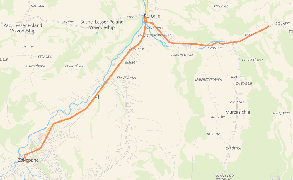
Distance between Kowalówka and Zakopane
The distance from Kowalówka to Zakopane is 11 kilometers by road. Road takes approximately 13 minutes and goes through Mur, Stasikówka Dolna, Szostaki, Koślowa Rola, Łojasowa Rola, Wańkówka and Za Torem.
| Shortest distance by air | 9 km ✈️ |
| Car route length | 11 km 🚗 |
| Driving time | 13 min |
| Fuel amount | 0.9 L |
| Fuel cost | 1.6 AUD |
| Point | Distance | Time | Fuel | |
| Kowalówka | 0 km | 00 min | 0.0 L | |
|
961 1 km, 01 min
|
||||
| Stasikówka Dolna | 1 km | 01 min | 0.1 L | |
|
961 0 km, 00 min
|
||||
| Szostaki | 2 km | 02 min | 0.1 L | |
|
961 1 km, 01 min
|
||||
| Koślowa Rola | 3 km | 03 min | 0.2 L | |
|
961 1 km, 01 min
|
||||
| Wańkówka | 4 km | 05 min | 0.3 L | |
|
961 2 km, 01 min
|
||||
| Za Torem | 6 km | 06 min | 0.4 L | |
|
47 6 km, 06 min
|
||||
| Zakopane | 11 km | 13 min | 0.7 L | |
Hotels of Zakopane
Frequently Asked Questions
How much does it cost to drive from Kowalówka to Zakopane?
Fuel cost: 1.6 AUD
This fuel cost is calculated as: (Route length 11 km / 100 km) * (Fuel consumption 8 L/100 km) * (Fuel price 1.8 AUD / L)
You can adjust fuel consumption and fuel price here.
How long is a car ride from Kowalówka to Zakopane?
Driving time: 13 min
This time is calculated for driving at the maximum permitted speed, taking into account traffic rules restrictions.
- 9 km with a maximum speed 50 km/h = 10 min
- 2 km with a maximum speed 40 km/h = 2 min
The calculated driving time does not take into account intermediate stops and traffic jams.
How far is Kowalówka to Zakopane by land?
The distance between Kowalówka and Zakopane is 11 km by road.
Precise satellite coordinates of highways were used for this calculation. The start and finish points are the centers of Kowalówka and Zakopane respectively.
What city is halfway between Kowalówka and Zakopane?
Where is Kowalówka in relation to Zakopane?
Kowalówka is located 9 km north-east of Zakopane.
Kowalówka has geographic coordinates: latitude 49.33699, longitude 20.05727.
Zakopane has geographic coordinates: latitude 49.29694, longitude 19.95066.
Which highway goes from Kowalówka to Zakopane?
The route from Kowalówka to Zakopane follows 47, 961.
Other minor sections pass along the road:
- 958: 1 km