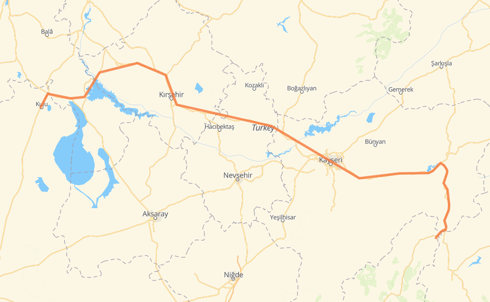
Distance between Kulu and Katarası
The distance from Kulu to Katarası is 425 kilometers by road. Road takes approximately 5 hours and 17 minutes and goes through Kayseri, Hacıabdullah, Baraj Sitesi, Kaman, Yeni, Gölhisar and Kındam Mah..
| Shortest distance by air | 300 km ✈️ |
| Car route length | 425 km 🚗 |
| Driving time | 5 h 17 min |
| Fuel amount | 34 L |
| Fuel cost | 61.2 AUD |
| Point | Distance | Time | Fuel | |
| Kulu | 0 km | 00 min | 0.0 L | |
|
D715 D750 56 km, 45 min
|
||||
| Hacıabdullah | 56 km | 45 min | 4.3 L | |
|
D757 3 km, 02 min
|
||||
| Baraj Sitesi | 59 km | 47 min | 4.7 L | |
|
D757 40-77 24 km, 18 min
|
||||
| Kaman | 83 km | 1 h 06 min | 5.9 L | |
|
D-260 D765 57 km, 41 min
|
||||
| Gölhisar | 141 km | 1 h 47 min | 10.8 L | |
|
D260 14 km, 10 min
|
||||
| Mucur | 155 km | 1 h 58 min | 11.8 L | |
|
D260 104 km, 1 h 16 min
|
||||
| 30 Ağustos Mah. | 259 km | 3 h 14 min | 20.4 L | |
|
8 km, 05 min
|
||||
| Kayseri | 267 km | 3 h 19 min | 21.3 L | |
|
4 km, 02 min
|
||||
| Mehmet Akif Ersoy | 270 km | 3 h 22 min | 21.4 L | |
|
300-18 155 km, 1 h 54 min
|
||||
| Katarası | 425 km | 5 h 17 min | 33.4 L | |
Frequently Asked Questions
How much does it cost to drive from Kulu to Katarası?
Fuel cost: 61.2 AUD
This fuel cost is calculated as: (Route length 425 km / 100 km) * (Fuel consumption 8 L/100 km) * (Fuel price 1.8 AUD / L)
You can adjust fuel consumption and fuel price here.
How long is a car ride from Kulu to Katarası?
Driving time: 5 h 17 min
This time is calculated for driving at the maximum permitted speed, taking into account traffic rules restrictions.
- 70 km with a maximum speed 90 km/h = 46 min
- 344 km with a maximum speed 80 km/h = 4 h 18 min
- 10 km with a maximum speed 50 km/h = 11 min
The calculated driving time does not take into account intermediate stops and traffic jams.
How far is Kulu to Katarası by land?
The distance between Kulu and Katarası is 425 km by road.
Precise satellite coordinates of highways were used for this calculation. The start and finish points are the centers of Kulu and Katarası respectively.
How far is Kulu to Katarası by plane?
The shortest distance (air line, as the crow flies) between Kulu and Katarası is 300 km.
This distance is calculated using the Haversine formula as a great-circle distance between two points on the surface of a sphere. The start and finish points are the centers of Kulu and Katarası respectively. Actual distance between airports may be different.
How many hours is Kulu from Katarası by plane?
Boeing 737 airliner needs 22 min to cover the distance of 300 km at a cruising speed of 800 km/h.
Small plane "Cessna 172" needs 1 h 21 min to flight this distance at average speed of 220 km/h.
This time is approximate and do not take into account takeoff and landing times, airport location and other real world factors.
How long is a helicopter ride from Kulu to Katarası?
Fast helicopter "Eurocopter AS350" or "Hughes OH-6 Cayuse" need 1 h 15 min to cover the distance of 300 km at a cruising speed of 240 km/h.
Popular "Robinson R44" needs 1 h 25 min to flight this distance at average speed of 210 km/h.
This time is approximate and do not take into account takeoff and landing times, aerodrome location and other real world factors.
What city is halfway between Kulu and Katarası?
The halfway point between Kulu and Katarası is Kalaba. It is located about 1 km from the exact midpoint by road.
The distance from Kalaba to Kulu is 212 km and driving will take about 2 h 39 min. The road between Kalaba and Katarası has length 213 km and will take approximately 2 h 37 min.
The other cities located close to halfway point:
Where is Kulu in relation to Katarası?
Kulu is located 300 km west of Katarası.
Kulu has geographic coordinates: latitude 39.08917, longitude 33.08056.
Katarası has geographic coordinates: latitude 38.23354, longitude 36.36.