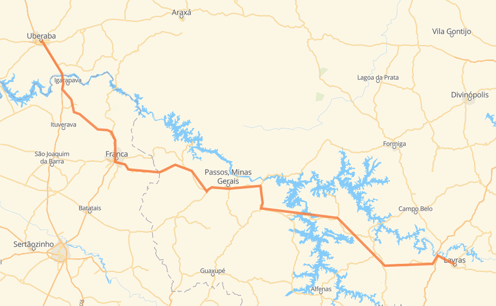
Distance between Lavras and Uberaba
The distance from Lavras to Uberaba is 459 kilometers by road including 93 kilometers on motorways. Road takes approximately 5 hours and 41 minutes and goes through Nepomuceno, Distrito Industrial de Boa Esperança, Ilicínea, Alpinópolis, Itaú de Minas, São José and Jardim Vera Cruz III.
| Shortest distance by air | 348 km ✈️ |
| Car route length | 459 km 🚗 |
| Driving time | 5 h 41 min |
| Fuel amount | 36.7 L |
| Fuel cost | 66.4 AUD |
| Point | Distance | Time | Fuel | |
| Lavras | 0 km | 00 min | 0.0 L | |
|
BR-265 33 km, 28 min
|
||||
| Nepomuceno | 33 km | 28 min | 2.1 L | |
|
BR-265 52 km, 44 min
|
||||
| Distrito Industrial de Boa Esperança | 85 km | 1 h 12 min | 6.7 L | |
|
BR-369 BR-265 45 km, 37 min
|
||||
| Ilicínea | 131 km | 1 h 50 min | 9.6 L | |
|
BR-265 58 km, 48 min
|
||||
| Alpinópolis | 189 km | 2 h 38 min | 14.1 L | |
|
MG-446 MG-050 59 km, 41 min
|
||||
| Itaú de Minas | 248 km | 3 h 20 min | 19.0 L | |
|
MG-050 MG-344 32 km, 22 min
|
||||
| São José | 280 km | 3 h 42 min | 22.1 L | |
|
MG-444 SP-345 65 km, 42 min
|
||||
| Jardim Vera Cruz III | 346 km | 4 h 25 min | 27.1 L | |
|
SP-334 BR-050 106 km, 1 h 09 min
|
||||
| Jardim Itália | 451 km | 5 h 35 min | 35.9 L | |
|
BR-050 8 km, 05 min
|
||||
| Uberaba | 459 km | 5 h 41 min | 36.6 L | |
Frequently Asked Questions
How much does it cost to drive from Lavras to Uberaba?
Fuel cost: 66.4 AUD
This fuel cost is calculated as: (Route length 459 km / 100 km) * (Fuel consumption 8 L/100 km) * (Fuel price 1.81 AUD / L)
You can adjust fuel consumption and fuel price here.
How long is a car ride from Lavras to Uberaba?
Driving time: 5 h 41 min
This time is calculated for driving at the maximum permitted speed, taking into account traffic rules restrictions.
- 19 km with a maximum speed 110 km/h = 10 min
- 68 km with a maximum speed 100 km/h = 40 min
- 105 km with a maximum speed 90 km/h = 1 h 10 min
- 228 km with a maximum speed 80 km/h = 2 h 51 min
- 17 km with a maximum speed 60 km/h = 17 min
- 2 km with a maximum speed 50 km/h = 2 min
- 19 km with a maximum speed 40 km/h = 28 min
The calculated driving time does not take into account intermediate stops and traffic jams.
How far is Lavras to Uberaba by land?
The distance between Lavras and Uberaba is 459 km by road including 93 km on motorways.
Precise satellite coordinates of highways were used for this calculation. The start and finish points are the centers of Lavras and Uberaba respectively.
How far is Lavras to Uberaba by plane?
The shortest distance (air line, as the crow flies) between Lavras and Uberaba is 348 km.
This distance is calculated using the Haversine formula as a great-circle distance between two points on the surface of a sphere. The start and finish points are the centers of Lavras and Uberaba respectively. Actual distance between airports may be different.
How many hours is Lavras from Uberaba by plane?
Boeing 737 airliner needs 26 min to cover the distance of 348 km at a cruising speed of 800 km/h.
Small plane "Cessna 172" needs 1 h 34 min to flight this distance at average speed of 220 km/h.
This time is approximate and do not take into account takeoff and landing times, airport location and other real world factors.
How long is a helicopter ride from Lavras to Uberaba?
Fast helicopter "Eurocopter AS350" or "Hughes OH-6 Cayuse" need 1 h 27 min to cover the distance of 348 km at a cruising speed of 240 km/h.
Popular "Robinson R44" needs 1 h 39 min to flight this distance at average speed of 210 km/h.
This time is approximate and do not take into account takeoff and landing times, aerodrome location and other real world factors.
What city is halfway between Lavras and Uberaba?
The halfway point between Lavras and Uberaba is Itaú de Minas. It is located about 19 km from the exact midpoint by road.
The distance from Itaú de Minas to Lavras is 248 km and driving will take about 3 h 20 min. The road between Itaú de Minas and Uberaba has length 211 km and will take approximately 2 h 21 min.
The other cities located close to halfway point:
Where is Lavras in relation to Uberaba?
Lavras is located 348 km south-east of Uberaba.
Lavras has geographic coordinates: latitude -21.24255, longitude -44.9992.
Uberaba has geographic coordinates: latitude -19.75083, longitude -47.93667.
Which highway goes from Lavras to Uberaba?
The route from Lavras to Uberaba follows BR-265.
Other minor sections pass along the road:
- MG-050: 41 km
- BR-050: 36 km
- SP-345: 35 km
- MG-344: 26 km
- SP-334: 25 km
- MG-444: 24 km
- MG-446: 21 km
- BTZ-030: 21 km
- MGC-265: 18 km
- BR-369: 13 km
- SP-330: 10 km
- LMG-863: 5 km
- BR-381: 5 km