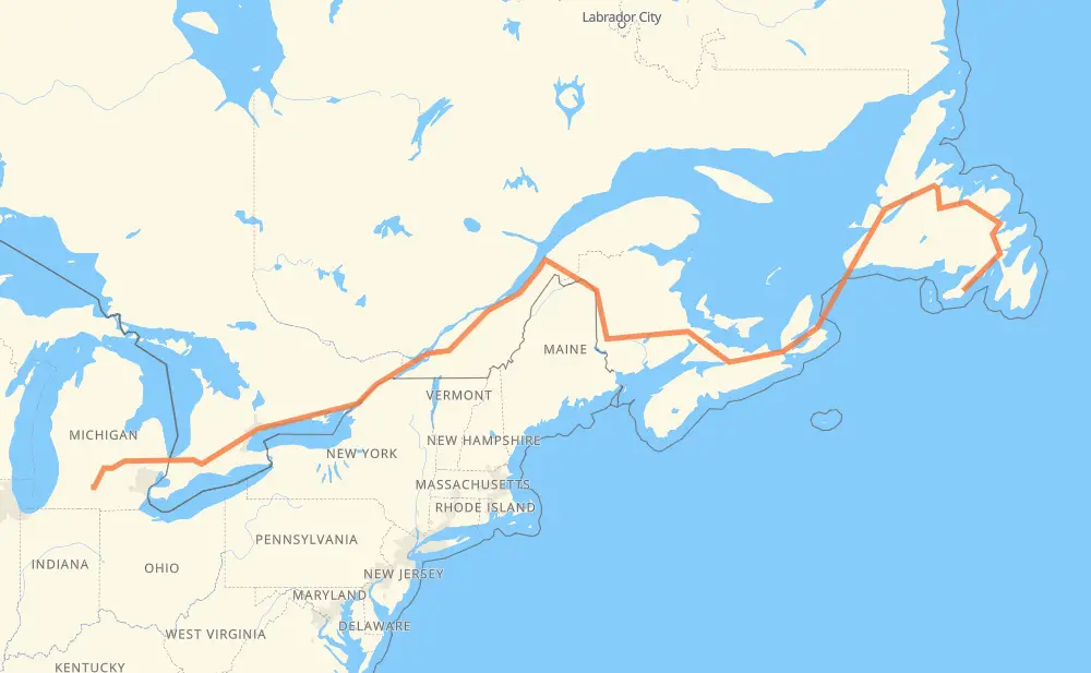
Distance between Lewin's Cove NL and Wattles Park MI
The distance from Lewin's Cove to Wattles Park is 3,626 kilometers by road including 2,383 kilometers on motorways. Road takes approximately 43 hours and 57 minutes and goes through Corner Brook, Moncton, Fredericton, Lévis, Drummondville, Longueuil and Montreal.
| Shortest distance by air | 2,407 km ✈️ |
| Car route length | 3,626 km 🚗 |
| Driving time | 43 h 57 min |
| Fuel amount | 290 L |
| Fuel cost | 516.3 AUD |
| Point | Distance | Time | Fuel | |
| Lewin's Cove | 0 km | 00 min | 0.0 L | |
|
220 1 689 km, 7 h 42 min
|
||||
| Corner Brook | 689 km | 7 h 42 min | 53.9 L | |
|
1 TCH 860 km, 15 h 57 min
|
||||
| Moncton | 1,550 km | 23 h 39 min | 123.2 L | |
|
2 170 km, 1 h 32 min
|
||||
| Fredericton | 1,720 km | 25 h 12 min | 137.2 L | |
|
2 550 km, 5 h 17 min
|
||||
| Lévis | 2,269 km | 30 h 29 min | 180.4 L | |
|
20 160 km, 1 h 35 min
|
||||
| Drummondville | 2,429 km | 32 h 05 min | 193.8 L | |
|
20 87 km, 52 min
|
||||
| Longueuil | 2,516 km | 32 h 57 min | 201.2 L | |
|
25 16 km, 12 min
|
||||
| Montreal | 2,532 km | 33 h 10 min | 201.4 L | |
|
40 401 109 km, 1 h 09 min
|
||||
| Cornwall | 2,641 km | 34 h 19 min | 211.0 L | |
|
401 92 km, 55 min
|
||||
| Brockville | 2,733 km | 35 h 14 min | 218.1 L | |
|
401 79 km, 47 min
|
||||
| Kingston | 2,812 km | 36 h 01 min | 223.4 L | |
|
401 77 km, 45 min
|
||||
| Belleville | 2,888 km | 36 h 47 min | 230.1 L | |
|
401 126 km, 1 h 15 min
|
||||
| Oshawa | 3,014 km | 38 h 03 min | 240.8 L | |
|
401 15 km, 08 min
|
||||
| Ajax | 3,028 km | 38 h 11 min | 242.0 L | |
|
401 32 km, 19 min
|
||||
| Toronto | 3,060 km | 38 h 30 min | 243.1 L | |
|
401 31 km, 18 min
|
||||
| Mississauga | 3,091 km | 38 h 49 min | 246.5 L | |
|
401 66 km, 39 min
|
||||
| Kitchener | 3,157 km | 39 h 29 min | 252.3 L | |
|
401 42 km, 25 min
|
||||
| Woodstock | 3,199 km | 39 h 54 min | 255.5 L | |
|
401 402 140 km, 1 h 19 min
|
||||
| Sarnia | 3,339 km | 41 h 13 min | 266.4 L | |
|
402 I 69 122 km, 1 h 12 min
|
||||
| Flint | 3,461 km | 42 h 26 min | 276.5 L | |
|
I 69 99 km, 53 min
|
||||
| Lansing | 3,560 km | 43 h 20 min | 284.6 L | |
|
I 69 66 km, 36 min
|
||||
| Wattles Park | 3,626 km | 43 h 57 min | 290.0 L | |
Frequently Asked Questions
How much does it cost to drive from Lewin's Cove to Wattles Park?
Fuel cost: 516.3 AUD
This fuel cost is calculated as: (Route length 3,626 km / 100 km) * (Fuel consumption 8 L/100 km) * (Fuel price 1.78 AUD / L)
You can adjust fuel consumption and fuel price here.
How long is a car ride from Lewin's Cove to Wattles Park?
Driving time: 43 h 57 min
This time is calculated for driving at the maximum permitted speed, taking into account traffic rules restrictions.
- 954 km with a maximum speed 110 km/h = 8 h 40 min
- 1,389 km with a maximum speed 100 km/h = 13 h 53 min
- 1,015 km with a maximum speed 90 km/h = 11 h 16 min
- 46 km with a maximum speed 80 km/h = 34 min
- 32 km with a maximum speed 70 km/h = 27 min
- 3 km with a maximum speed 65 km/h = 2 min
- 8 km with a maximum speed 50 km/h = 9 min
- 177 km with a maximum speed 20 km/h = 8 h 52 min
The calculated driving time does not take into account intermediate stops and traffic jams.
How far is Lewin's Cove to Wattles Park by land?
The distance between Lewin's Cove and Wattles Park is 3,626 km by road including 2,383 km on motorways.
Precise satellite coordinates of highways were used for this calculation. The start and finish points are the centers of Lewin's Cove and Wattles Park respectively.
How far is Lewin's Cove to Wattles Park by plane?
The shortest distance (air line, as the crow flies) between Lewin's Cove and Wattles Park is 2,407 km.
This distance is calculated using the Haversine formula as a great-circle distance between two points on the surface of a sphere. The start and finish points are the centers of Lewin's Cove and Wattles Park respectively. Actual distance between airports may be different.
How many hours is Lewin's Cove from Wattles Park by plane?
Boeing 737 airliner needs 3 h to cover the distance of 2,407 km at a cruising speed of 800 km/h.
Small plane "Cessna 172" needs 10 h 56 min to flight this distance at average speed of 220 km/h.
This time is approximate and do not take into account takeoff and landing times, airport location and other real world factors.
How long is a helicopter ride from Lewin's Cove to Wattles Park?
Fast helicopter "Eurocopter AS350" or "Hughes OH-6 Cayuse" need 10 h 1 min to cover the distance of 2,407 km at a cruising speed of 240 km/h.
Popular "Robinson R44" needs 11 h 27 min to flight this distance at average speed of 210 km/h.
This time is approximate and do not take into account takeoff and landing times, aerodrome location and other real world factors.
What city is halfway between Lewin's Cove and Wattles Park?
The halfway point between Lewin's Cove and Wattles Park is Meductic. It is located about 17 km from the exact midpoint by road.
The distance from Meductic to Lewin's Cove is 1,796 km and driving will take about 25 h 53 min. The road between Meductic and Wattles Park has length 1,829 km and will take approximately 18 h 4 min.
The other cities located close to halfway point:
Where is Lewin's Cove in relation to Wattles Park?
Lewin's Cove is located 2,407 km east of Wattles Park.
Lewin's Cove has geographic coordinates: latitude 47.08948, longitude -55.21757.
Wattles Park has geographic coordinates: latitude 42.3006, longitude -85.11082.
Which highway goes from Lewin's Cove to Wattles Park?
The route from Lewin's Cove to Wattles Park follows 1, 401, TCH, 2, 20, NS 104, I 69, 210, NS 105, 402.
Other minor sections pass along the road:
- 85: 62 km
- 40: 47 km
- 185: 38 km
- 55: 35 km
- 7: 11 km
- I 94: 10 km
- 25: 8 km
- I 96: 8 km
- 220: 7 km
- 105: 6 km
- 220A: 5 km
- 116: 5 km
- NS 4: 4 km
- NB 2: 2 km
- 15: 2 km
- I 94 BL: 2 km
- M 96: 2 km
- 30: 2 km
- 201: 2 km
- 232: 2 km