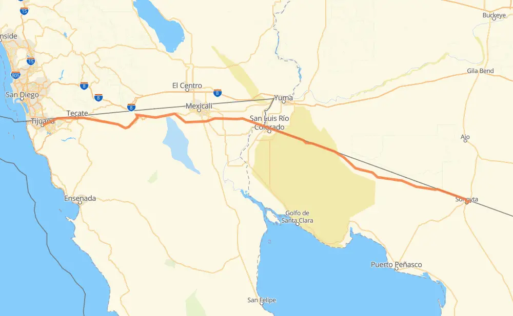
Distance between Lukeville AZ and Tijuana
The distance from Lukeville to Tijuana is 438 kilometers by road including 222 kilometers on motorways. Road takes approximately 5 hours and 2 minutes and goes through San Luis Rio Colorado, Sonoyta, Ejido Hermosillo, Monterrey Batáquez, Queretaro, Sinaloa and Ciudad Progreso.
| Shortest distance by air | 396 km ✈️ |
| Car route length | 438 km 🚗 |
| Driving time | 5 h 2 min |
| Fuel amount | 35.1 L |
| Fuel cost | 62.8 AUD |
| Toll roads cost | 110 + ? MXN |
| Point | Distance | Time | Fuel | |
| Lukeville | 0 km | 00 min | 0.0 L | |
|
AZ 85 MEX 8 3 km, 04 min
|
||||
| Sonoyta | 3 km | 04 min | 0.0 L | |
|
MEX 8 MEX 2 4 km, 05 min
|
||||
| Taller Mecanico Barraza | 7 km | 09 min | 0.4 L | |
|
MEX 2 6 km, 03 min
|
||||
| Morelia | 13 km | 13 min | 0.7 L | |
|
MEX 2 5 km, 03 min
|
||||
| Cafe el Trece | 17 km | 16 min | 1.3 L | |
|
MEX 2 186 km, 2 h 05 min
|
||||
| San Luis Rio Colorado | 203 km | 2 h 22 min | 16.0 L | |
|
MEX 2 17 km, 12 min
|
||||
| Ejido Hermosillo | 220 km | 2 h 35 min | 17.1 L | |
|
MEX 2 33 km, 23 min
|
||||
| Sinaloa | 254 km | 2 h 59 min | 19.9 L | |
|
MEX 2 MEX 2D 31 km, 20 min
|
||||
| Ciudad Progreso | 285 km | 3 h 19 min | 22.0 L | |
|
MEX 2D 155 km, 1 h 43 min
|
||||
| Tijuana | 440 km | 5 h 02 min | 34.8 L | |
Hotels of Tijuana
Frequently Asked Questions
How many toll booths are there from Lukeville to Tijuana?
There are 5 toll booths between Lukeville and Tijuana: Tijuana-Tecate, El Hongo, La Rumorosa, Mexicali Omega and San Luis Rio Colorado.
How much does the toll booths cost from Lukeville to Tijuana?
Toll roads cost: San Luis Rio Colorado (?) + Mexicali Omega (?) + La Rumorosa (26 MXN) + El Hongo (84 MXN) + Tijuana-Tecate (?) = 110 + ? MXN
How much does it cost to drive from Lukeville to Tijuana?
Fuel cost: 62.8 AUD
This fuel cost is calculated as: (Route length 438 km / 100 km) * (Fuel consumption 8 L/100 km) * (Fuel price 1.79 AUD / L)
You can adjust fuel consumption and fuel price here.
Toll roads cost: 110 + ? MXN
How long is a car ride from Lukeville to Tijuana?
Driving time: 5 h 2 min
This time is calculated for driving at the maximum permitted speed, taking into account traffic rules restrictions.
- 24 km with a maximum speed 110 km/h = 13 min
- 73 km with a maximum speed 100 km/h = 43 min
- 247 km with a maximum speed 90 km/h = 2 h 44 min
- 77 km with a maximum speed 80 km/h = 57 min
- 15 km with a maximum speed 60 km/h = 15 min
- 3 km with a maximum speed 30 km/h = 5 min
- 1 km with a maximum speed 20 km/h = 1 min
The calculated driving time does not take into account intermediate stops and traffic jams.
How far is Lukeville to Tijuana by land?
The distance between Lukeville and Tijuana is 438 km by road including 222 km on motorways.
Precise satellite coordinates of highways were used for this calculation. The start and finish points are the centers of Lukeville and Tijuana respectively.
How far is Lukeville to Tijuana by plane?
The shortest distance (air line, as the crow flies) between Lukeville and Tijuana is 396 km.
This distance is calculated using the Haversine formula as a great-circle distance between two points on the surface of a sphere. The start and finish points are the centers of Lukeville and Tijuana respectively. Actual distance between airports may be different.
How many hours is Lukeville from Tijuana by plane?
Boeing 737 airliner needs 29 min to cover the distance of 396 km at a cruising speed of 800 km/h.
Small plane "Cessna 172" needs 1 h 48 min to flight this distance at average speed of 220 km/h.
This time is approximate and do not take into account takeoff and landing times, airport location and other real world factors.
How long is a helicopter ride from Lukeville to Tijuana?
Fast helicopter "Eurocopter AS350" or "Hughes OH-6 Cayuse" need 1 h 39 min to cover the distance of 396 km at a cruising speed of 240 km/h.
Popular "Robinson R44" needs 1 h 53 min to flight this distance at average speed of 210 km/h.
This time is approximate and do not take into account takeoff and landing times, aerodrome location and other real world factors.
What city is halfway between Lukeville and Tijuana?
The halfway point between Lukeville and Tijuana is Ejido Hermosillo. It is located about 1 km from the exact midpoint by road.
The distance from Ejido Hermosillo to Lukeville is 220 km and driving will take about 2 h 35 min. The road between Ejido Hermosillo and Tijuana has length 218 km and will take approximately 2 h 27 min.
The other cities located close to halfway point:
Where is Lukeville in relation to Tijuana?
Lukeville is located 396 km east of Tijuana.
Lukeville has geographic coordinates: latitude 31.88257, longitude -112.81571.
Tijuana has geographic coordinates: latitude 32.50086, longitude -116.96417.
Which highway goes from Lukeville to Tijuana?
The route from Lukeville to Tijuana follows MEX 2, MEX 2D.
Other minor sections pass along the road:
- MEX 8: 3 km