Distance between Mankayan and Sikatuna
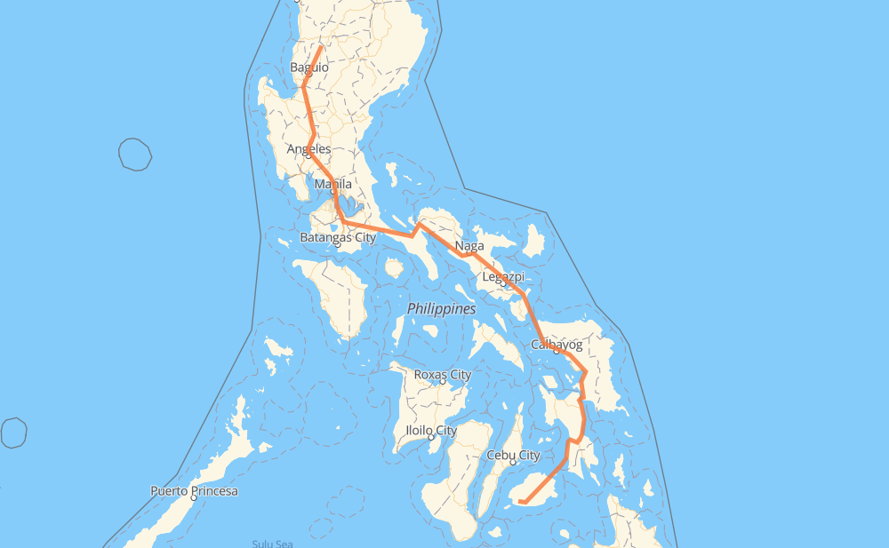
The distance from Mankayan to Sikatuna is 1,484 kilometers by road including 256 kilometers on motorways. Road takes approximately 21 hours and 34 minutes and goes through San Pedro, Biñan, Santa Rosa, Cabuyao, Calamba, San Pablo and Naga.
| Shortest distance by air | 868 km ✈️ |
| Car route length | 1,484 km 🚗 |
| Driving time | 21 h 34 min |
| Fuel amount | 118.7 L |
| Fuel cost | 213.7 AUD |
| Point | Distance | Time | Fuel | |
| Mankayan | 0 km | 00 min | 0.0 L | |
|
E1 371 km, 4 h 24 min
|
||||
| San Pedro | 371 km | 4 h 24 min | 29.5 L | |
|
E2 5 km, 03 min
|
||||
| Biñan | 376 km | 4 h 27 min | 29.8 L | |
|
E2 6 km, 03 min
|
||||
| Santa Rosa | 382 km | 4 h 31 min | 30.4 L | |
|
E2 3 km, 01 min
|
||||
| Cabuyao | 385 km | 4 h 33 min | 30.8 L | |
|
E2 6 km, 03 min
|
||||
| Calamba | 392 km | 4 h 37 min | 30.9 L | |
|
E2 AH26 35 km, 26 min
|
||||
| San Pablo | 426 km | 5 h 03 min | 33.6 L | |
|
1 301 km, 3 h 55 min
|
||||
| Naga | 727 km | 8 h 58 min | 57.8 L | |
|
1 61 km, 51 min
|
||||
| Ligao | 788 km | 9 h 50 min | 62.7 L | |
|
1 81 km, 1 h 00 min
|
||||
| Sorsogon City | 870 km | 10 h 50 min | 69.4 L | |
|
1 145 km, 2 h 43 min
|
||||
| Calbayog | 1,015 km | 13 h 34 min | 79.1 L | |
|
1 83 km, 1 h 15 min
|
||||
| Catbalogan | 1,098 km | 14 h 49 min | 86.7 L | |
|
1 100 km, 1 h 22 min
|
||||
| Tacloban | 1,198 km | 16 h 12 min | 95.5 L | |
|
1 106 km, 1 h 22 min
|
||||
| Baybay | 1,304 km | 17 h 34 min | 102.7 L | |
|
70 852 181 km, 3 h 59 min
|
||||
| Sikatuna | 1,485 km | 21 h 34 min | 118.5 L | |
Frequently Asked Questions
How much does it cost to drive from Mankayan to Sikatuna?
Fuel cost: 213.7 AUD
This fuel cost is calculated as: (Route length 1,484 km / 100 km) * (Fuel consumption 8 L/100 km) * (Fuel price 1.8 AUD / L)
You can adjust fuel consumption and fuel price here.
How long is a car ride from Mankayan to Sikatuna?
Driving time: 21 h 34 min
This time is calculated for driving at the maximum permitted speed, taking into account traffic rules restrictions.
- 248 km with a maximum speed 100 km/h = 2 h 28 min
- 110 km with a maximum speed 90 km/h = 1 h 13 min
- 871 km with a maximum speed 80 km/h = 10 h 53 min
- 34 km with a maximum speed 70 km/h = 28 min
- 55 km with a maximum speed 60 km/h = 54 min
- 82 km with a maximum speed 50 km/h = 1 h 38 min
- 14 km with a maximum speed 40 km/h = 20 min
- 3 km with a maximum speed 30 km/h = 5 min
- 71 km with a maximum speed 20 km/h = 3 h 31 min
The calculated driving time does not take into account intermediate stops and traffic jams.
How far is Mankayan to Sikatuna by land?
The distance between Mankayan and Sikatuna is 1,484 km by road including 256 km on motorways.
Precise satellite coordinates of highways were used for this calculation. The start and finish points are the centers of Mankayan and Sikatuna respectively.
How far is Mankayan to Sikatuna by plane?
The shortest distance (air line, as the crow flies) between Mankayan and Sikatuna is 868 km.
This distance is calculated using the Haversine formula as a great-circle distance between two points on the surface of a sphere. The start and finish points are the centers of Mankayan and Sikatuna respectively. Actual distance between airports may be different.
How many hours is Mankayan from Sikatuna by plane?
Boeing 737 airliner needs 1 h 5 min to cover the distance of 868 km at a cruising speed of 800 km/h.
Small plane "Cessna 172" needs 3 h 56 min to flight this distance at average speed of 220 km/h.
This time is approximate and do not take into account takeoff and landing times, airport location and other real world factors.
How long is a helicopter ride from Mankayan to Sikatuna?
Fast helicopter "Eurocopter AS350" or "Hughes OH-6 Cayuse" need 3 h 37 min to cover the distance of 868 km at a cruising speed of 240 km/h.
Popular "Robinson R44" needs 4 h 8 min to flight this distance at average speed of 210 km/h.
This time is approximate and do not take into account takeoff and landing times, aerodrome location and other real world factors.
What city is halfway between Mankayan and Sikatuna?
The halfway point between Mankayan and Sikatuna is Baao. It is located about 12 km from the exact midpoint by road.
The distance from Baao to Mankayan is 754 km and driving will take about 9 h 20 min. The road between Baao and Sikatuna has length 730 km and will take approximately 12 h 13 min.
The other cities located close to halfway point:
Where is Mankayan in relation to Sikatuna?
Mankayan is located 868 km north-west of Sikatuna.
Mankayan has geographic coordinates: latitude 16.85725, longitude 120.79414.
Sikatuna has geographic coordinates: latitude 9.68784, longitude 123.97406.
Which highway goes from Mankayan to Sikatuna?
The route from Mankayan to Sikatuna follows AH26, 1, E1.
Other minor sections pass along the road:
- 68: 93 km
- 204: 72 km
- 852: 61 km
- E2: 52 km
- 692: 37 km
- 54: 30 km
- 70: 22 km
- 609: 8 km
- 231: 6 km
- 140: 5 km
- 160: 4 km
- 673: 4 km
- 608: 3 km
- Shilan-Beckel Road: 3 km
- 145: 3 km
- 110: 3 km
- 161: 1 km
- 850: 1 km