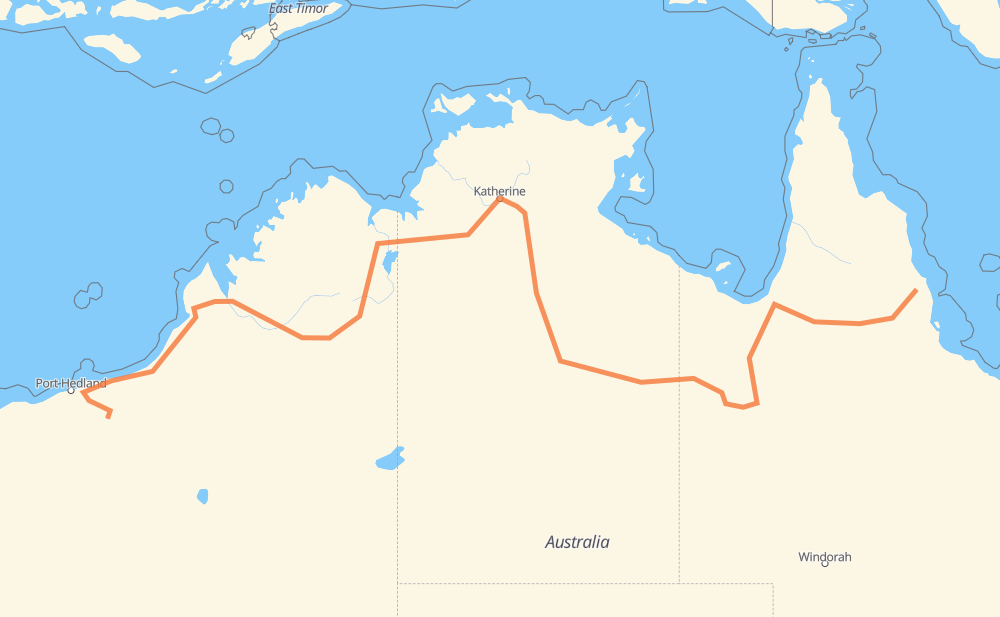
Distance between Marble Bar and Yungaburra
The distance from Marble Bar to Yungaburra is 4,586 kilometers by road. Road takes approximately 51 hours and 21 minutes and goes through Mount Isa, Fitzroy Crossing, Kununurra, Bulla, Katherine, Elliott and Cloncurry.
| Shortest distance by air | 2,745 km ✈️ |
| Car route length | 4,586 km 🚗 |
| Driving time | 51 h 21 min |
| Fuel amount | 366.9 L |
| Fuel cost | 664 AUD |
| Point | Distance | Time | Fuel | |
| Marble Bar | 0 km | 00 min | 0.0 L | |
|
1 1,020 km, 11 h 21 min
|
||||
| Fitzroy Crossing | 1,020 km | 11 h 21 min | 79.8 L | |
|
1 667 km, 7 h 27 min
|
||||
| Kununurra | 1,687 km | 18 h 48 min | 134.9 L | |
|
1 181 km, 2 h 01 min
|
||||
| Bulla | 1,868 km | 20 h 49 min | 148.4 L | |
|
1 341 km, 3 h 48 min
|
||||
| Katherine | 2,209 km | 24 h 38 min | 176.5 L | |
|
1 420 km, 4 h 42 min
|
||||
| Elliott | 2,629 km | 29 h 20 min | 210.0 L | |
|
87 66 867 km, 9 h 40 min
|
||||
| Mount Isa | 3,496 km | 39 h 01 min | 278.8 L | |
|
A2 83 113 km, 1 h 16 min
|
||||
| Cloncurry | 3,610 km | 40 h 17 min | 288.3 L | |
|
83 523 km, 5 h 50 min
|
||||
| Croydon | 4,133 km | 46 h 08 min | 330.2 L | |
|
1 463 km, 5 h 13 min
|
||||
| Yungaburra | 4,596 km | 51 h 21 min | 367.3 L | |
Hotels of Yungaburra
Frequently Asked Questions
How much does it cost to drive from Marble Bar to Yungaburra?
Fuel cost: 664 AUD
This fuel cost is calculated as: (Route length 4,586 km / 100 km) * (Fuel consumption 8 L/100 km) * (Fuel price 1.81 AUD / L)
You can adjust fuel consumption and fuel price here.
How long is a car ride from Marble Bar to Yungaburra?
Driving time: 51 h 21 min
This time is calculated for driving at the maximum permitted speed, taking into account traffic rules restrictions.
- 4,479 km with a maximum speed 90 km/h = 49 h 45 min
- 85 km with a maximum speed 80 km/h = 1 h 3 min
- 2 km with a maximum speed 70 km/h = 1 min
- 29 km with a maximum speed 60 km/h = 29 min
- 1 km with a maximum speed 50 km/h = 1 min
The calculated driving time does not take into account intermediate stops and traffic jams.
How far is Marble Bar to Yungaburra by land?
The distance between Marble Bar and Yungaburra is 4,586 km by road.
Precise satellite coordinates of highways were used for this calculation. The start and finish points are the centers of Marble Bar and Yungaburra respectively.
How far is Marble Bar to Yungaburra by plane?
The shortest distance (air line, as the crow flies) between Marble Bar and Yungaburra is 2,745 km.
This distance is calculated using the Haversine formula as a great-circle distance between two points on the surface of a sphere. The start and finish points are the centers of Marble Bar and Yungaburra respectively. Actual distance between airports may be different.
How many hours is Marble Bar from Yungaburra by plane?
Boeing 737 airliner needs 3 h 25 min to cover the distance of 2,745 km at a cruising speed of 800 km/h.
Small plane "Cessna 172" needs 12 h 28 min to flight this distance at average speed of 220 km/h.
This time is approximate and do not take into account takeoff and landing times, airport location and other real world factors.
How long is a helicopter ride from Marble Bar to Yungaburra?
Fast helicopter "Eurocopter AS350" or "Hughes OH-6 Cayuse" need 11 h 26 min to cover the distance of 2,745 km at a cruising speed of 240 km/h.
Popular "Robinson R44" needs 13 h 4 min to flight this distance at average speed of 210 km/h.
This time is approximate and do not take into account takeoff and landing times, aerodrome location and other real world factors.
What city is halfway between Marble Bar and Yungaburra?
The halfway point between Marble Bar and Yungaburra is Mataranka. It is located about 23 km from the exact midpoint by road.
The distance from Mataranka to Marble Bar is 2,316 km and driving will take about 25 h 49 min. The road between Mataranka and Yungaburra has length 2,270 km and will take approximately 25 h 31 min.
The other cities located close to halfway point:
Where is Marble Bar in relation to Yungaburra?
Marble Bar is located 2,745 km west of Yungaburra.
Marble Bar has geographic coordinates: latitude -21.17149, longitude 119.74562.
Yungaburra has geographic coordinates: latitude -17.26996, longitude 145.58327.
Which highway goes from Marble Bar to Yungaburra?
The route from Marble Bar to Yungaburra follows 1, 83, 66, 87, A2, 138.
Other minor sections pass along the road:
- 25: 2 km
- 84: 1 km