Distance between Mineral IL and Fraser CO
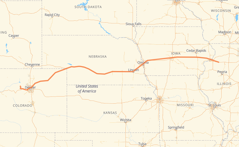
The distance from Mineral to Fraser is 1,527 kilometers by road including 1,470 kilometers on motorways. Road takes approximately 14 hours and 19 minutes and goes through Davenport, Iowa City, Omaha, Lincoln, North Platte and Denver.
| Shortest distance by air | 1,356 km ✈️ |
| Car route length | 1,527 km 🚗 |
| Driving time | 14 h 19 min |
| Fuel amount | 122.2 L |
| Fuel cost | 220 AUD |
| Point | Distance | Time | Fuel | |
| Mineral | 0 km | 00 min | 0.0 L | |
|
US 6 I 80 45 km, 26 min
|
||||
| Colona | 45 km | 26 min | 3.5 L | |
|
I 280 I 74 11 km, 06 min
|
||||
| Moline | 56 km | 32 min | 4.0 L | |
|
I 280 24 km, 13 min
|
||||
| Davenport | 80 km | 45 min | 5.7 L | |
|
I 280 I 80 79 km, 43 min
|
||||
| Iowa City | 159 km | 1 h 29 min | 12.5 L | |
|
I 80 403 km, 3 h 43 min
|
||||
| Omaha | 562 km | 5 h 13 min | 44.2 L | |
|
I 80 78 km, 43 min
|
||||
| Lincoln | 640 km | 5 h 56 min | 50.6 L | |
|
I 80 371 km, 3 h 22 min
|
||||
| North Platte | 1,011 km | 9 h 19 min | 79.3 L | |
|
I 80 I 76 407 km, 3 h 42 min
|
||||
| Denver | 1,417 km | 13 h 01 min | 113.4 L | |
|
I 76 US 40 111 km, 1 h 18 min
|
||||
| Fraser | 1,529 km | 14 h 20 min | 122.0 L | |
Hotels of Fraser
Frequently Asked Questions
How much does it cost to drive from Mineral to Fraser?
Fuel cost: 220 AUD
This fuel cost is calculated as: (Route length 1,527 km / 100 km) * (Fuel consumption 8 L/100 km) * (Fuel price 1.8 AUD / L)
You can adjust fuel consumption and fuel price here.
How long is a car ride from Mineral to Fraser?
Driving time: 14 h 19 min
This time is calculated for driving at the maximum permitted speed, taking into account traffic rules restrictions.
- 1,258 km with a maximum speed 110 km/h = 11 h 26 min
- 174 km with a maximum speed 105 km/h = 1 h 39 min
- 4 km with a maximum speed 100 km/h = 2 min
- 10 km with a maximum speed 97 km/h = 6 min
- 23 km with a maximum speed 90 km/h = 15 min
- 9 km with a maximum speed 89 km/h = 6 min
- 23 km with a maximum speed 80 km/h = 17 min
- 6 km with a maximum speed 72 km/h = 4 min
- 19 km with a maximum speed 56 km/h = 20 min
The calculated driving time does not take into account intermediate stops and traffic jams.
How far is Mineral to Fraser by land?
The distance between Mineral and Fraser is 1,527 km by road including 1,470 km on motorways.
Precise satellite coordinates of highways were used for this calculation. The start and finish points are the centers of Mineral and Fraser respectively.
How far is Mineral to Fraser by plane?
The shortest distance (air line, as the crow flies) between Mineral and Fraser is 1,356 km.
This distance is calculated using the Haversine formula as a great-circle distance between two points on the surface of a sphere. The start and finish points are the centers of Mineral and Fraser respectively. Actual distance between airports may be different.
How many hours is Mineral from Fraser by plane?
Boeing 737 airliner needs 1 h 41 min to cover the distance of 1,356 km at a cruising speed of 800 km/h.
Small plane "Cessna 172" needs 6 h 9 min to flight this distance at average speed of 220 km/h.
This time is approximate and do not take into account takeoff and landing times, airport location and other real world factors.
How long is a helicopter ride from Mineral to Fraser?
Fast helicopter "Eurocopter AS350" or "Hughes OH-6 Cayuse" need 5 h 39 min to cover the distance of 1,356 km at a cruising speed of 240 km/h.
Popular "Robinson R44" needs 6 h 27 min to flight this distance at average speed of 210 km/h.
This time is approximate and do not take into account takeoff and landing times, aerodrome location and other real world factors.
What city is halfway between Mineral and Fraser?
The halfway point between Mineral and Fraser is Aurora. It is located about 14 km from the exact midpoint by road.
The distance from Aurora to Mineral is 750 km and driving will take about 6 h 56 min. The road between Aurora and Fraser has length 777 km and will take approximately 7 h 22 min.
The other cities located close to halfway point:
Where is Mineral in relation to Fraser?
Mineral is located 1,356 km east of Fraser.
Mineral has geographic coordinates: latitude 41.38266, longitude -89.83649.
Fraser has geographic coordinates: latitude 39.94729, longitude -105.81542.
Which highway goes from Mineral to Fraser?
The route from Mineral to Fraser follows I 80, US 6, I 76.
Other minor sections pass along the road:
- US 40: 71 km
- I 70: 59 km
- I 280: 44 km
- CO 52: 22 km
- I 35: 22 km
- I 74: 15 km
- US 34: 14 km
- US 77: 12 km
- US 61: 9 km
- US 85: 4 km
- I 29: 4 km
- US 65: 2 km
- IL 78: 1 km