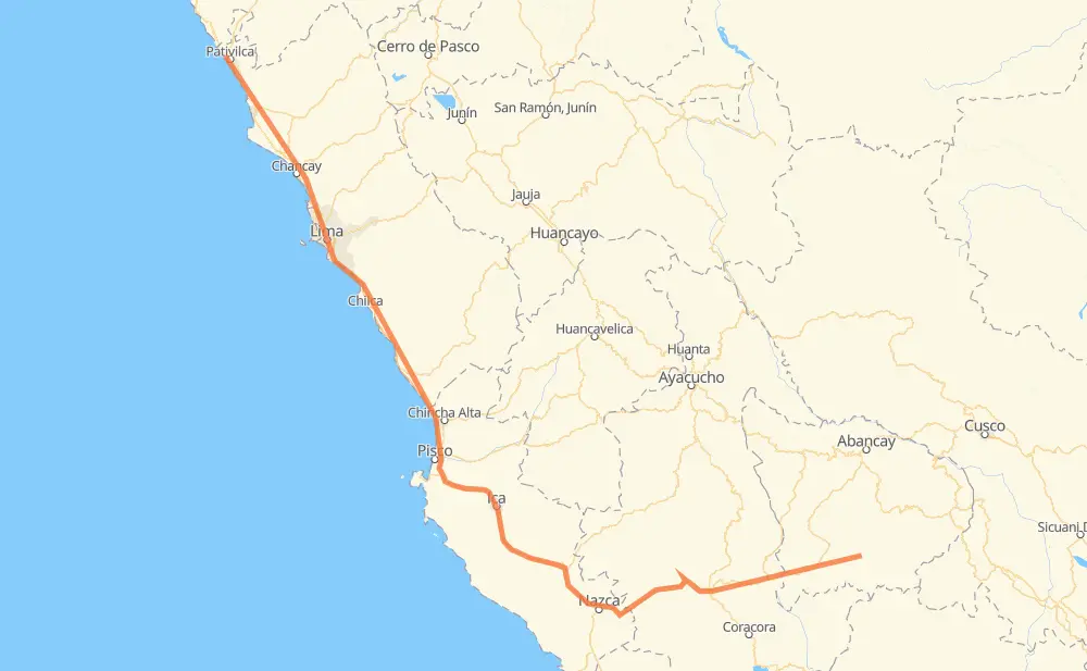
The distance from Mollebamba to Paramonga is 1,041 kilometers by road including 228 kilometers on motorways. Road takes approximately 13 hours and 4 minutes and goes through Caraybamba, Cotaruse, Lucanas, Santiago, Subtanjalla, Guadalupe and Interplayas.
How much does it cost to drive from Mollebamba to Paramonga?
Fuel cost:
146.6 AUD
This fuel cost is calculated as: (Route length 1,041 km / 100 km) * (Fuel consumption 8 L/100 km) * (Fuel price 1.76 AUD / L)
You can adjust fuel consumption and fuel price here.
How long is a car ride from Mollebamba to Paramonga?
Driving time:
13 h 4 min
This time is calculated for driving at the maximum permitted speed, taking into account traffic rules restrictions.
162 km with a maximum speed 100 km/h = 1 h 37 min
245 km with a maximum speed 90 km/h = 2 h 43 min
468 km with a maximum speed 80 km/h = 5 h 51 min
13 km with a maximum speed 70 km/h = 11 min
123 km with a maximum speed 60 km/h = 2 h 2 min
19 km with a maximum speed 50 km/h = 22 min
6 km with a maximum speed 40 km/h = 9 min
2 km with a maximum speed 35 km/h = 4 min
The calculated driving time does not take into account intermediate stops and traffic jams.
How far is Mollebamba to Paramonga by land?
The distance between Mollebamba and Paramonga is 1,041 km by road including 228 km on motorways.
Precise satellite coordinates of highways were used for this calculation. The start and finish points are the centers of Mollebamba and Paramonga respectively.
How far is Mollebamba to Paramonga by plane?
The shortest distance (air line, as the crow flies) between Mollebamba and Paramonga is 676 km.
This distance is calculated using the Haversine formula as a great-circle distance between two points on the surface of a sphere. The start and finish points are the centers of Mollebamba and Paramonga respectively. Actual distance between airports may be different.
How many hours is Mollebamba from Paramonga by plane?
Boeing 737 airliner needs 50 min to cover the distance of 676 km at a cruising speed of 800 km/h.
Small plane "Cessna 172" needs 3 h 4 min to flight this distance at average speed of 220 km/h.
This time is approximate and do not take into account takeoff and landing times, airport location and other real world factors.
How long is a helicopter ride from Mollebamba to Paramonga?
Fast helicopter "Eurocopter AS350" or "Hughes OH-6 Cayuse" need 2 h 49 min to cover the distance of 676 km at a cruising speed of 240 km/h.
Popular "Robinson R44" needs 3 h 13 min to flight this distance at average speed of 210 km/h.
This time is approximate and do not take into account takeoff and landing times, aerodrome location and other real world factors.
What city is halfway between Mollebamba and Paramonga?
The halfway point between Mollebamba and Paramonga is Fundo Santa María.
The distance from Fundo Santa María to Mollebamba is 521 km and driving will take about 6 h 45 min. The road between Fundo Santa María and Paramonga has length 521 km and will take approximately 6 h 18 min.
The other cities located close to halfway point:
La Joya is in 516 km from Mollebamba and 526 km from Paramonga
San Cayetano is in 530 km from Mollebamba and 511 km from Paramonga
Aguada de Palos is in 508 km from Mollebamba and 534 km from Paramonga
Where is Mollebamba in relation to Paramonga?
Mollebamba is located 676 km south-east of Paramonga.
Mollebamba has geographic coordinates: latitude -14.42859, longitude -72.91465.
Paramonga has geographic coordinates: latitude -10.67519, longitude -77.81853.
Which highway goes from Mollebamba to Paramonga?
The route from Mollebamba to Paramonga follows PE-1S, PE-30A, PE-1N.