Distance between Moncton NB and Bangor SK
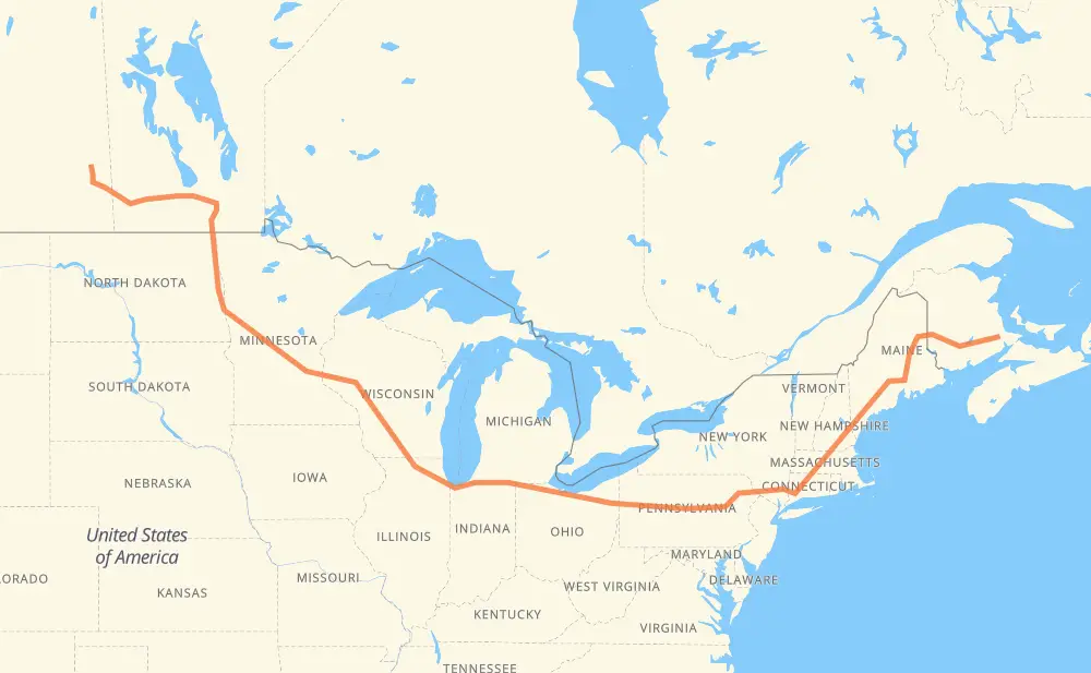
The distance from Moncton to Bangor is 4,279 kilometers by road including 3,693 kilometers on motorways. Road takes approximately 41 hours and 49 minutes and goes through Fredericton, Bangor, Waterville, Augusta, Portland, Lowell and Hartford.
| Shortest distance by air | 2,787 km ✈️ |
| Car route length | 4,279 km 🚗 |
| Driving time | 41 h 49 min |
| Fuel amount | 342.3 L |
| Fuel cost | 612.8 AUD |
| Point | Distance | Time | Fuel | |
| Moncton | 0 km | 00 min | 0.0 L | |
|
128 2 169 km, 1 h 34 min
|
||||
| Fredericton | 169 km | 1 h 34 min | 13.1 L | |
|
2 I 95 305 km, 2 h 56 min
|
||||
| Bangor | 474 km | 4 h 31 min | 37.0 L | |
|
I 95 101 km, 55 min
|
||||
| Waterville | 575 km | 5 h 27 min | 44.8 L | |
|
I 95 20 km, 11 min
|
||||
| Augusta | 595 km | 5 h 38 min | 47.2 L | |
|
I 95 I 295 88 km, 49 min
|
||||
| Portland | 683 km | 6 h 27 min | 54.4 L | |
|
I 295 I 95 155 km, 1 h 29 min
|
||||
| Lowell | 838 km | 7 h 57 min | 66.9 L | |
|
I 495 I 84 179 km, 1 h 46 min
|
||||
| Hartford | 1,017 km | 9 h 44 min | 81.1 L | |
|
I 84 43 km, 26 min
|
||||
| Waterbury | 1,060 km | 10 h 11 min | 84.3 L | |
|
I 84 261 km, 2 h 34 min
|
||||
| Scranton | 1,321 km | 12 h 45 min | 105.4 L | |
|
I 81 I 80 615 km, 5 h 41 min
|
||||
| Elyria | 1,937 km | 18 h 26 min | 154.7 L | |
|
I 80 137 km, 1 h 14 min
|
||||
| Toledo | 2,074 km | 19 h 41 min | 165.6 L | |
|
I 80 234 km, 2 h 07 min
|
||||
| South Bend | 2,308 km | 21 h 49 min | 184.1 L | |
|
I 80 I 90 315 km, 3 h 02 min
|
||||
| Janesville | 2,623 km | 24 h 52 min | 209.5 L | |
|
I 39 56 km, 30 min
|
||||
| Madison | 2,679 km | 25 h 22 min | 213.6 L | |
|
I 39 I 94 282 km, 2 h 34 min
|
||||
| Eau Claire | 2,961 km | 27 h 57 min | 236.0 L | |
|
I 94 526 km, 4 h 52 min
|
||||
| Fargo | 3,487 km | 32 h 50 min | 278.2 L | |
|
I 29 102 km, 1 h 10 min
|
||||
| Grand Forks | 3,589 km | 34 h 00 min | 285.1 L | |
|
I 29 243 km, 2 h 47 min
|
||||
| Winnipeg | 3,832 km | 36 h 47 min | 305.6 L | |
|
PTH 100 PTH 1 88 km, 59 min
|
||||
| Portage la Prairie | 3,920 km | 37 h 47 min | 313.0 L | |
|
PTH 1 123 km, 1 h 22 min
|
||||
| Brandon | 4,043 km | 39 h 09 min | 323.2 L | |
|
PTH 1 246 km, 2 h 46 min
|
||||
| Bangor | 4,289 km | 41 h 55 min | 342.9 L | |
Frequently Asked Questions
How much does it cost to drive from Moncton to Bangor?
Fuel cost: 612.8 AUD
This fuel cost is calculated as: (Route length 4,279 km / 100 km) * (Fuel consumption 8 L/100 km) * (Fuel price 1.79 AUD / L)
You can adjust fuel consumption and fuel price here.
How long is a car ride from Moncton to Bangor?
Driving time: 41 h 49 min
This time is calculated for driving at the maximum permitted speed, taking into account traffic rules restrictions.
- 2,568 km with a maximum speed 110 km/h = 23 h 20 min
- 537 km with a maximum speed 105 km/h = 5 h 7 min
- 174 km with a maximum speed 100 km/h = 1 h 44 min
- 59 km with a maximum speed 97 km/h = 36 min
- 511 km with a maximum speed 90 km/h = 5 h 40 min
- 99 km with a maximum speed 89 km/h = 1 h 6 min
- 15 km with a maximum speed 80 km/h = 10 min
- 303 km with a maximum speed 80 km/h = 3 h 47 min
- 5 km with a maximum speed 72 km/h = 4 min
- 2 km with a maximum speed 60 km/h = 2 min
- 4 km with a maximum speed 50 km/h = 4 min
The calculated driving time does not take into account intermediate stops and traffic jams.
How far is Moncton to Bangor by land?
The distance between Moncton and Bangor is 4,279 km by road including 3,693 km on motorways.
Precise satellite coordinates of highways were used for this calculation. The start and finish points are the centers of Moncton and Bangor respectively.
How far is Moncton to Bangor by plane?
The shortest distance (air line, as the crow flies) between Moncton and Bangor is 2,787 km.
This distance is calculated using the Haversine formula as a great-circle distance between two points on the surface of a sphere. The start and finish points are the centers of Moncton and Bangor respectively. Actual distance between airports may be different.
How many hours is Moncton from Bangor by plane?
Boeing 737 airliner needs 3 h 29 min to cover the distance of 2,787 km at a cruising speed of 800 km/h.
Small plane "Cessna 172" needs 12 h 40 min to flight this distance at average speed of 220 km/h.
This time is approximate and do not take into account takeoff and landing times, airport location and other real world factors.
How long is a helicopter ride from Moncton to Bangor?
Fast helicopter "Eurocopter AS350" or "Hughes OH-6 Cayuse" need 11 h 36 min to cover the distance of 2,787 km at a cruising speed of 240 km/h.
Popular "Robinson R44" needs 13 h 16 min to flight this distance at average speed of 210 km/h.
This time is approximate and do not take into account takeoff and landing times, aerodrome location and other real world factors.
What city is halfway between Moncton and Bangor?
The halfway point between Moncton and Bangor is Jamestown. It is located about 57 km from the exact midpoint by road.
The distance from Jamestown to Moncton is 2,196 km and driving will take about 20 h 46 min. The road between Jamestown and Bangor has length 2,083 km and will take approximately 21 h 2 min.
The other cities located close to halfway point:
Where is Moncton in relation to Bangor?
Moncton is located 2,787 km east of Bangor.
Moncton has geographic coordinates: latitude 46.098, longitude -64.80011.
Bangor has geographic coordinates: latitude 50.80682, longitude -102.34106.
Which highway goes from Moncton to Bangor?
The route from Moncton to Bangor follows I 80, I 90, I 94, I 95, I 84, PTH 1, 2, I 29, US 81, I 39, I 495.
Other minor sections pass along the road:
- PTH 75: 94 km
- I 295: 86 km
- 1: 67 km
- I 81: 56 km
- I 694: 46 km
- 9: 39 km
- US 6: 37 km
- US 51: 30 km
- US 220: 26 km
- US 41: 22 km
- PTH 100: 19 km
- US 59: 17 km
- 95: 14 km
- 7: 11 km
- NY 52: 11 km
- 128: 9 km
- US 12: 9 km
- PTH 83: 7 km
- MN 95: 7 km
- SR 11: 6 km
- 105: 6 km
- US 1: 6 km
- PA 66: 6 km
- US 7: 6 km
- PA 309: 6 km
- I 380: 5 km
- US 202: 5 km
- PR 254: 5 km
- MN 210: 5 km
- US 220 Alternate: 5 km
- US 10: 5 km
- ME 15: 4 km
- US 52: 4 km
- PR 241: 4 km
- WI 35: 4 km
- PA 28 Truck: 4 km
- PR 250: 4 km
- US 20: 3 km
- WI 11: 3 km
- Route 42: 3 km
- TCH: 3 km
- PR 427: 2 km
- PR 334: 2 km
- PTH 10: 2 km
- 22: 2 km
- 8: 1 km