Distance between Montauban and Saint-Claude
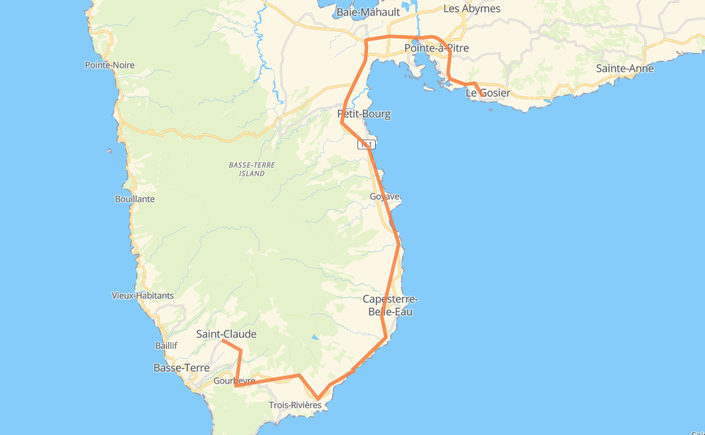
The distance from Montauban to Saint-Claude is 67 kilometers by road. Road takes approximately 51 minutes and goes through Le Gosier, Les Abymes, Baie-Mahault, Petit-Bourg, Capesterre-Belle-Eau and Moulin à Eau.
| Shortest distance by air | 30 km ✈️ |
| Car route length | 67 km 🚗 |
| Driving time | 51 min |
| Fuel amount | 5.4 L |
| Fuel cost | 9.5 AUD |
| Point | Distance | Time | Fuel | |
| Le Gosier | 0 km | 00 min | 0.0 L | |
|
N 4 7 km, 05 min
|
||||
| Les Abymes | 7 km | 05 min | 0.3 L | |
|
N 1 6 km, 03 min
|
||||
| Baie-Mahault | 13 km | 09 min | 0.8 L | |
|
N 1 8 km, 05 min
|
||||
| Petit-Bourg | 21 km | 15 min | 1.3 L | |
|
N 1 8 km, 05 min
|
||||
| Goyave | 29 km | 20 min | 2.2 L | |
|
N 1 12 km, 08 min
|
||||
| Capesterre-Belle-Eau | 41 km | 29 min | 2.5 L | |
|
N 1 27 km, 22 min
|
||||
| Saint-Claude | 67 km | 51 min | 5.0 L | |
Hotels of Saint-Claude
Frequently Asked Questions
How much does it cost to drive from Montauban to Saint-Claude?
Fuel cost: 9.5 AUD
This fuel cost is calculated as: (Route length 67 km / 100 km) * (Fuel consumption 8 L/100 km) * (Fuel price 1.76 AUD / L)
You can adjust fuel consumption and fuel price here.
How long is a car ride from Montauban to Saint-Claude?
Driving time: 51 min
This time is calculated for driving at the maximum permitted speed, taking into account traffic rules restrictions.
- 36 km with a maximum speed 90 km/h = 23 min
- 16 km with a maximum speed 80 km/h = 11 min
- 9 km with a maximum speed 70 km/h = 8 min
- 6 km with a maximum speed 50 km/h = 7 min
The calculated driving time does not take into account intermediate stops and traffic jams.
How far is Montauban to Saint-Claude by land?
The distance between Montauban and Saint-Claude is 67 km by road.
Precise satellite coordinates of highways were used for this calculation. The start and finish points are the centers of Montauban and Saint-Claude respectively.
What city is halfway between Montauban and Saint-Claude?
The halfway point between Montauban and Saint-Claude is Goyave. It is located about 5 km from the exact midpoint by road.
The distance from Goyave to Montauban is 29 km and driving will take about 20 min. The road between Goyave and Saint-Claude has length 38 km and will take approximately 31 min.
The other cities located close to halfway point:
Where is Montauban in relation to Saint-Claude?
Montauban is located 30 km north-east of Saint-Claude.
Montauban has geographic coordinates: latitude 16.20912, longitude -61.49686.
Saint-Claude has geographic coordinates: latitude 16.02606, longitude -61.70118.
Which highway goes from Montauban to Saint-Claude?
The route from Montauban to Saint-Claude follows N 1.
Other minor sections pass along the road:
- D 9: 5 km
- N 4: 3 km
- D 119: 1 km