Distance between Montreuil and Rueil-Malmaison
The distance from Montreuil to Rueil-Malmaison is 25 kilometers by road including 1 kilometer on motorways. Road takes approximately 23 minutes and goes through París, Romainville, Bagnolet, Les Lilas, Neuilly-sur-Seine, Courbevoie and La Défense.
| Shortest distance by air | 19 km ✈️ |
| Car route length | 25 km 🚗 |
| Driving time | 23 min |
| Fuel amount | 2 L |
| Fuel cost | 3.5 AUD |
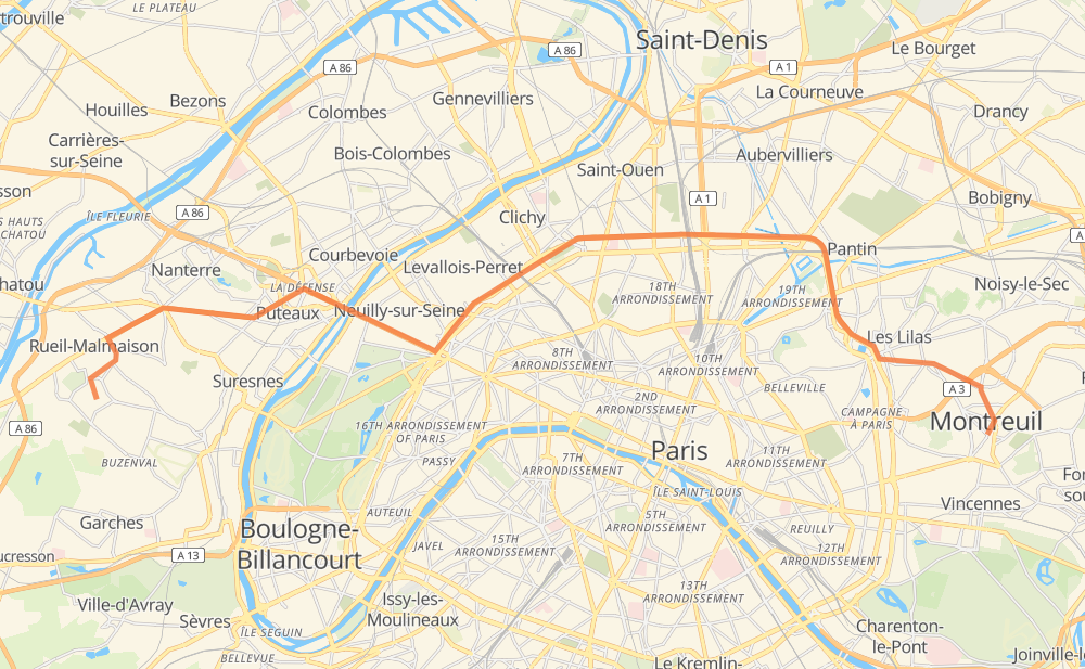
| Point | Distance | Time | Fuel | |
| Montreuil | 0 km | 00 min | 0.0 L | |
|
D 36bis 2 km, 02 min
|
||||
| Bagnolet | 2 km | 02 min | 0.1 L | |
|
D 20a 1 km, 00 min
|
||||
| Les Lilas | 3 km | 02 min | 0.2 L | |
|
D 20a 6 km, 05 min
|
||||
| París | 9 km | 08 min | 0.2 L | |
|
D 20a 7 km, 06 min
|
||||
| Neuilly-sur-Seine | 17 km | 14 min | 1.3 L | |
|
N 13 1 km, 01 min
|
||||
| Courbevoie | 18 km | 15 min | 1.4 L | |
|
N 1014 2 km, 02 min
|
||||
| Nanterre | 20 km | 18 min | 1.4 L | |
|
D 913 5 km, 05 min
|
||||
| Rueil-Malmaison | 25 km | 23 min | 1.8 L | |
Hotels of Rueil-Malmaison
Frequently Asked Questions
How much does it cost to drive from Montreuil to Rueil-Malmaison?
Fuel cost: 3.5 AUD
This fuel cost is calculated as: (Route length 25 km / 100 km) * (Fuel consumption 8 L/100 km) * (Fuel price 1.76 AUD / L)
You can adjust fuel consumption and fuel price here.
How long is a car ride from Montreuil to Rueil-Malmaison?
Driving time: 23 min
This time is calculated for driving at the maximum permitted speed, taking into account traffic rules restrictions.
- 5 km with a maximum speed 80 km/h = 3 min
- 13 km with a maximum speed 70 km/h = 11 min
- 6 km with a maximum speed 50 km/h = 7 min
- 1 km with a maximum speed 30 km/h = 1 min
The calculated driving time does not take into account intermediate stops and traffic jams.
How far is Montreuil to Rueil-Malmaison by land?
The distance between Montreuil and Rueil-Malmaison is 25 km by road including 1 km on motorways.
Precise satellite coordinates of highways were used for this calculation. The start and finish points are the centers of Montreuil and Rueil-Malmaison respectively.
What city is halfway between Montreuil and Rueil-Malmaison?
Where is Montreuil in relation to Rueil-Malmaison?
Montreuil is located 19 km east of Rueil-Malmaison.
Montreuil has geographic coordinates: latitude 48.86234, longitude 2.44122.
Rueil-Malmaison has geographic coordinates: latitude 48.86939, longitude 2.18088.
Which highway goes from Montreuil to Rueil-Malmaison?
The route from Montreuil to Rueil-Malmaison follows D 913.
Other minor sections pass along the road:
- N 13: 2 km
- D 20a: 2 km
- D 39: 1 km