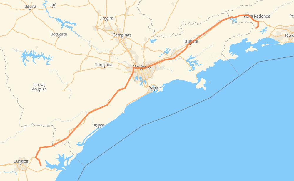
Distance between Morretes and Rio Claro
The distance from Morretes to Rio Claro is 749 kilometers by road including 712 kilometers on motorways. Road takes approximately 8 hours and 11 minutes and goes through Taboão da Serra, Jacareí, Guaratinguetá, Antonina, Bica da Onça, Manecão and Conchas.
| Shortest distance by air | 567 km ✈️ |
| Car route length | 749 km 🚗 |
| Driving time | 8 h 11 min |
| Fuel amount | 60 L |
| Fuel cost | 107.9 AUD |
| Point | Distance | Time | Fuel | |
| Morretes | 0 km | 00 min | 0.0 L | |
|
PR-411 BR-116 78 km, 1 h 00 min
|
||||
| Antonina | 78 km | 1 h 00 min | 4.8 L | |
|
BR-116 46 km, 32 min
|
||||
| Bica da Onça | 124 km | 1 h 33 min | 9.2 L | |
|
SP-230 23 km, 14 min
|
||||
| Manecão | 147 km | 1 h 47 min | 11.3 L | |
|
SP-230 8 km, 05 min
|
||||
| Conchas | 155 km | 1 h 52 min | 12.1 L | |
|
SP-230 46 km, 30 min
|
||||
| Jacupiranga | 201 km | 2 h 23 min | 15.5 L | |
|
SP-230 151 km, 1 h 29 min
|
||||
| Bairro do Soturno | 352 km | 3 h 53 min | 27.9 L | |
|
SP-230 36 km, 21 min
|
||||
| Taboão da Serra | 389 km | 4 h 14 min | 31.1 L | |
|
SP-230 SP-070 114 km, 1 h 10 min
|
||||
| Jacareí | 503 km | 5 h 24 min | 39.9 L | |
|
SP-070 SP-060 103 km, 1 h 00 min
|
||||
| Guaratinguetá | 606 km | 6 h 25 min | 48.2 L | |
|
SP-060 BR-116 161 km, 1 h 46 min
|
||||
| -22.72300, -44.13600 | 767 km | 8 h 11 min | 61.4 L | |
Frequently Asked Questions
How much does it cost to drive from Morretes to Rio Claro?
Fuel cost: 107.9 AUD
This fuel cost is calculated as: (Route length 749 km / 100 km) * (Fuel consumption 8 L/100 km) * (Fuel price 1.8 AUD / L)
You can adjust fuel consumption and fuel price here.
How long is a car ride from Morretes to Rio Claro?
Driving time: 8 h 11 min
This time is calculated for driving at the maximum permitted speed, taking into account traffic rules restrictions.
- 398 km with a maximum speed 110 km/h = 3 h 36 min
- 150 km with a maximum speed 100 km/h = 1 h 29 min
- 43 km with a maximum speed 90 km/h = 28 min
- 98 km with a maximum speed 80 km/h = 1 h 13 min
- 11 km with a maximum speed 70 km/h = 9 min
- 50 km with a maximum speed 60 km/h = 49 min
- 9 km with a maximum speed 50 km/h = 10 min
- 8 km with a maximum speed 40 km/h = 12 min
The calculated driving time does not take into account intermediate stops and traffic jams.
How far is Morretes to Rio Claro by land?
The distance between Morretes and Rio Claro is 749 km by road including 712 km on motorways.
Precise satellite coordinates of highways were used for this calculation. The start and finish points are the centers of Morretes and Rio Claro respectively.
How far is Morretes to Rio Claro by plane?
The shortest distance (air line, as the crow flies) between Morretes and Rio Claro is 567 km.
This distance is calculated using the Haversine formula as a great-circle distance between two points on the surface of a sphere. The start and finish points are the centers of Morretes and Rio Claro respectively. Actual distance between airports may be different.
How many hours is Morretes from Rio Claro by plane?
Boeing 737 airliner needs 42 min to cover the distance of 567 km at a cruising speed of 800 km/h.
Small plane "Cessna 172" needs 2 h 34 min to flight this distance at average speed of 220 km/h.
This time is approximate and do not take into account takeoff and landing times, airport location and other real world factors.
How long is a helicopter ride from Morretes to Rio Claro?
Fast helicopter "Eurocopter AS350" or "Hughes OH-6 Cayuse" need 2 h 21 min to cover the distance of 567 km at a cruising speed of 240 km/h.
Popular "Robinson R44" needs 2 h 42 min to flight this distance at average speed of 210 km/h.
This time is approximate and do not take into account takeoff and landing times, aerodrome location and other real world factors.
What city is halfway between Morretes and Rio Claro?
The halfway point between Morretes and Rio Claro is Taboão da Serra. It is located about 14 km from the exact midpoint by road.
The distance from Taboão da Serra to Morretes is 389 km and driving will take about 4 h 14 min. The road between Taboão da Serra and Rio Claro has length 361 km and will take approximately 3 h 57 min.
The other cities located close to halfway point:
Where is Morretes in relation to Rio Claro?
Morretes is located 567 km south-west of Rio Claro.
Morretes has geographic coordinates: latitude -25.47701, longitude -48.83219.
Rio Claro has geographic coordinates: latitude -22.723, longitude -44.136.
Which highway goes from Morretes to Rio Claro?
The route from Morretes to Rio Claro follows BR-116, SP-230, SP-060, SP-070.
Other minor sections pass along the road:
- BR-478: 48 km
- SP-015: 22 km
- PR-410: 19 km
- BR-459: 14 km
- PR-411: 13 km
- SP-021: 13 km
- BR-494: 12 km
- RJ-155: 12 km
- BR-383: 11 km
- VRD-001: 9 km
- BR-050: 7 km
- BR-374: 4 km
- SP-280: 4 km
- SPI 117/070: 3 km
- KM-272: 3 km
- SPM-280 E: 2 km
- RJ-139: 2 km
- SPI-016/021: 2 km