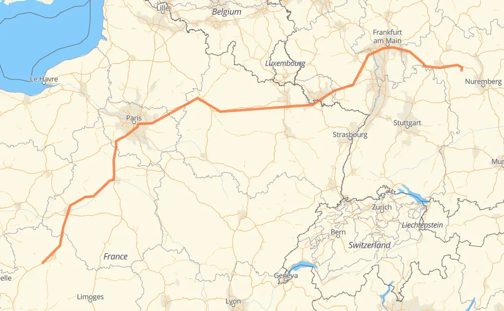
The distance from Moulin de Pairé to Frankfurt is 1,094 kilometers by road including 1,051 kilometers on motorways. Road takes approximately 10 hours and 54 minutes and goes through Poitiers, Tours, París, Reims, Kaiserslautern, Mainz and Offenbach del Meno.
How much does it cost to drive from Moulin de Pairé to Frankfurt?
Fuel cost:
154 AUD
This fuel cost is calculated as: (Route length 1,094 km / 100 km) * (Fuel consumption 8 L/100 km) * (Fuel price 1.76 AUD / L)
You can adjust fuel consumption and fuel price here.
How long is a car ride from Moulin de Pairé to Frankfurt?
Driving time:
10 h 54 min
This time is calculated for driving at the maximum permitted speed, taking into account traffic rules restrictions.
702 km with a maximum speed 110 km/h = 6 h 22 min
192 km with a maximum speed 100 km/h = 1 h 55 min
55 km with a maximum speed 90 km/h = 36 min
115 km with a maximum speed 80 km/h = 1 h 26 min
9 km with a maximum speed 70 km/h = 7 min
20 km with a maximum speed 50 km/h = 24 min
The calculated driving time does not take into account intermediate stops and traffic jams.
How far is Moulin de Pairé to Frankfurt by land?
The distance between Moulin de Pairé and Frankfurt is 1,094 km by road including 1,051 km on motorways.
Precise satellite coordinates of highways were used for this calculation. The start and finish points are the centers of Moulin de Pairé and Frankfurt respectively.
How far is Moulin de Pairé to Frankfurt by plane?
The shortest distance (air line, as the crow flies) between Moulin de Pairé and Frankfurt is 855 km.
This distance is calculated using the Haversine formula as a great-circle distance between two points on the surface of a sphere. The start and finish points are the centers of Moulin de Pairé and Frankfurt respectively. Actual distance between airports may be different.
How many hours is Moulin de Pairé from Frankfurt by plane?
Boeing 737 airliner needs 1 h 4 min to cover the distance of 855 km at a cruising speed of 800 km/h.
Small plane "Cessna 172" needs 3 h 53 min to flight this distance at average speed of 220 km/h.
This time is approximate and do not take into account takeoff and landing times, airport location and other real world factors.
How long is a helicopter ride from Moulin de Pairé to Frankfurt?
Fast helicopter "Eurocopter AS350" or "Hughes OH-6 Cayuse" need 3 h 33 min to cover the distance of 855 km at a cruising speed of 240 km/h.
Popular "Robinson R44" needs 4 h 4 min to flight this distance at average speed of 210 km/h.
This time is approximate and do not take into account takeoff and landing times, aerodrome location and other real world factors.
What city is halfway between Moulin de Pairé and Frankfurt?
The halfway point between Moulin de Pairé and Frankfurt is Saint-Étienne-au-Temple. It is located about 9 km from the exact midpoint by road.
The distance from Saint-Étienne-au-Temple to Moulin de Pairé is 538 km and driving will take about 5 h 9 min. The road between Saint-Étienne-au-Temple and Frankfurt has length 556 km and will take approximately 5 h 44 min.
The other cities located close to halfway point:
Argers is in 571 km from Moulin de Pairé and 523 km from Frankfurt
Les Petites-Loges is in 518 km from Moulin de Pairé and 576 km from Frankfurt
Verrières is in 576 km from Moulin de Pairé and 518 km from Frankfurt
Where is Moulin de Pairé in relation to Frankfurt?
Moulin de Pairé is located 855 km south-west of Frankfurt.
Moulin de Pairé has geographic coordinates: latitude 46.47723, longitude 0.05779.
Frankfurt has geographic coordinates: latitude 49.68061, longitude 10.52672.
Which highway goes from Moulin de Pairé to Frankfurt?
The route from Moulin de Pairé to Frankfurt follows A 4, A 10, A 3.