Distance between Nueva Rosita and Barrett CA
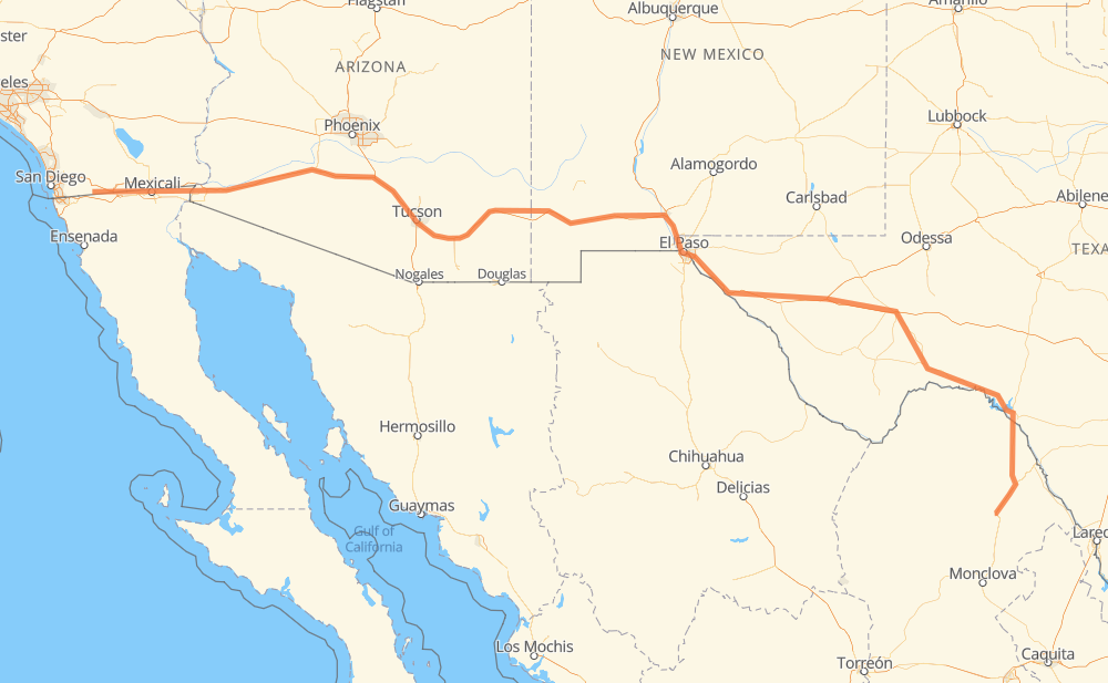
The distance from Nueva Rosita to Barrett is 1,949 kilometers by road including 1,500 kilometers on motorways. Road takes approximately 19 hours and 33 minutes and goes through Ciudad Acuña, Del Rio, El Paso, Tucson, Yuma and El Centro.
| Shortest distance by air | 1,552 km ✈️ |
| Car route length | 1,949 km 🚗 |
| Driving time | 19 h 33 min |
| Fuel amount | 155.9 L |
| Fuel cost | 280.7 AUD |
| Toll roads cost | 30 + ? MXN |
| Point | Distance | Time | Fuel | |
| Nueva Rosita | 0 km | 00 min | 0.0 L | |
|
MEX 57D 58 km, 32 min
|
||||
| Allende | 58 km | 32 min | 4.4 L | |
|
MEX 57 MEX 29 77 km, 54 min
|
||||
| San Carlos | 135 km | 1 h 27 min | 10.0 L | |
|
MEX 29 35 km, 24 min
|
||||
| Ciudad Acuña | 171 km | 1 h 51 min | 13.5 L | |
|
MEX 2 8 km, 07 min
|
||||
| Del Rio | 179 km | 1 h 58 min | 13.8 L | |
|
US 90 I 10 685 km, 7 h 03 min
|
||||
| El Paso | 864 km | 9 h 02 min | 68.6 L | |
|
Loop 375 I 10 501 km, 5 h 03 min
|
||||
| Tucson | 1,365 km | 14 h 06 min | 107.4 L | |
|
I 10 I 8 394 km, 3 h 38 min
|
||||
| Yuma | 1,759 km | 17 h 44 min | 140.1 L | |
|
I 8 89 km, 48 min
|
||||
| El Centro | 1,848 km | 18 h 33 min | 147.5 L | |
|
I 8 101 km, 59 min
|
||||
| Barrett | 1,949 km | 19 h 33 min | 154.6 L | |
Frequently Asked Questions
How many toll booths are there from Nueva Rosita to Barrett?
There are 2 toll booths between Nueva Rosita and Barrett: Ciudad Acuña and Autopista Premier.
How much does the toll booths cost from Nueva Rosita to Barrett?
Toll roads cost: Autopista Premier (?) + Ciudad Acuña (30 MXN) = 30 + ? MXN
How much does it cost to drive from Nueva Rosita to Barrett?
Fuel cost: 280.7 AUD
This fuel cost is calculated as: (Route length 1,949 km / 100 km) * (Fuel consumption 8 L/100 km) * (Fuel price 1.8 AUD / L)
You can adjust fuel consumption and fuel price here.
Toll roads cost: 30 + ? MXN
How long is a car ride from Nueva Rosita to Barrett?
Driving time: 19 h 33 min
This time is calculated for driving at the maximum permitted speed, taking into account traffic rules restrictions.
- 1,059 km with a maximum speed 110 km/h = 9 h 37 min
- 112 km with a maximum speed 105 km/h = 1 h 4 min
- 168 km with a maximum speed 100 km/h = 1 h 40 min
- 19 km with a maximum speed 97 km/h = 12 min
- 359 km with a maximum speed 90 km/h = 3 h 59 min
- 226 km with a maximum speed 80 km/h = 2 h 49 min
- 2 km with a maximum speed 50 km/h = 2 min
- 2 km with a maximum speed 30 km/h = 4 min
The calculated driving time does not take into account intermediate stops and traffic jams.
How far is Nueva Rosita to Barrett by land?
The distance between Nueva Rosita and Barrett is 1,949 km by road including 1,500 km on motorways.
Precise satellite coordinates of highways were used for this calculation. The start and finish points are the centers of Nueva Rosita and Barrett respectively.
How far is Nueva Rosita to Barrett by plane?
The shortest distance (air line, as the crow flies) between Nueva Rosita and Barrett is 1,552 km.
This distance is calculated using the Haversine formula as a great-circle distance between two points on the surface of a sphere. The start and finish points are the centers of Nueva Rosita and Barrett respectively. Actual distance between airports may be different.
How many hours is Nueva Rosita from Barrett by plane?
Boeing 737 airliner needs 1 h 56 min to cover the distance of 1,552 km at a cruising speed of 800 km/h.
Small plane "Cessna 172" needs 7 h 3 min to flight this distance at average speed of 220 km/h.
This time is approximate and do not take into account takeoff and landing times, airport location and other real world factors.
How long is a helicopter ride from Nueva Rosita to Barrett?
Fast helicopter "Eurocopter AS350" or "Hughes OH-6 Cayuse" need 6 h 28 min to cover the distance of 1,552 km at a cruising speed of 240 km/h.
Popular "Robinson R44" needs 7 h 23 min to flight this distance at average speed of 210 km/h.
This time is approximate and do not take into account takeoff and landing times, aerodrome location and other real world factors.
What city is halfway between Nueva Rosita and Barrett?
The halfway point between Nueva Rosita and Barrett is Las Cruces. It is located about 15 km from the exact midpoint by road.
The distance from Las Cruces to Nueva Rosita is 960 km and driving will take about 9 h 58 min. The road between Las Cruces and Barrett has length 989 km and will take approximately 9 h 35 min.
The other cities located close to halfway point:
Where is Nueva Rosita in relation to Barrett?
Nueva Rosita is located 1,552 km south-east of Barrett.
Nueva Rosita has geographic coordinates: latitude 27.93555, longitude -101.21965.
Barrett has geographic coordinates: latitude 32.62923, longitude -116.46057.
Which highway goes from Nueva Rosita to Barrett?
The route from Nueva Rosita to Barrett follows I 10, I 8, US 90, US 70, US 180, US 285, MEX 29.
Other minor sections pass along the road:
- MEX 57D: 52 km
- Loop 375: 33 km
- US 191: 32 km
- US 85: 21 km
- CA 94: 20 km
- US 67: 16 km
- MEX 57: 13 km
- US 377: 7 km
- US 277: 7 km
- TX 17: 3 km
- US 277 Spur: 3 km
- MEX 2: 3 km
- TX 18: 2 km
- I 10-G Business: 1 km
- Spur 239: 1 km