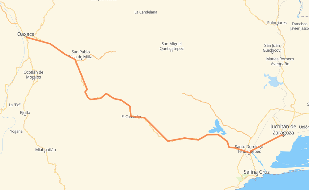
Distance between Oaxaca and Juchitán de Zaragoza
The distance from Oaxaca to Juchitán de Zaragoza is 277 kilometers by road. Road takes approximately 3 hours and 21 minutes and goes through Tlacolula, Santa María del Tule, Santiago Matatlán, San Pedro Totolapa, El Camarón and Santa María Jalapa del Marqués.
| Shortest distance by air | 195 km ✈️ |
| Car route length | 277 km 🚗 |
| Driving time | 3 h 21 min |
| Fuel amount | 22.2 L |
| Fuel cost | 40.2 AUD |
| Point | Distance | Time | Fuel | |
| Oaxaca | 0 km | 00 min | 0.0 L | |
|
MEX 190 12 km, 08 min
|
||||
| Santa María del Tule | 12 km | 08 min | 0.8 L | |
|
MEX 190 18 km, 12 min
|
||||
| Tlacolula | 30 km | 21 min | 2.0 L | |
|
MEX 190 18 km, 12 min
|
||||
| Santiago Matatlán | 48 km | 33 min | 3.6 L | |
|
MEX 190 34 km, 23 min
|
||||
| San Juan Guegoyachi | 82 km | 57 min | 5.9 L | |
|
MEX 190 20 km, 13 min
|
||||
| Las Margaritas | 102 km | 1 h 11 min | 7.9 L | |
|
MEX 190 10 km, 07 min
|
||||
| San José de Gracia | 111 km | 1 h 18 min | 8.3 L | |
|
MEX 190 22 km, 16 min
|
||||
| El Camarón | 133 km | 1 h 34 min | 9.5 L | |
|
MEX 190 89 km, 1 h 06 min
|
||||
| Santa María Jalapa del Marqués | 222 km | 2 h 41 min | 16.4 L | |
|
MEX 190 56 km, 40 min
|
||||
| Juchitán de Zaragoza | 277 km | 3 h 21 min | 21.2 L | |
Frequently Asked Questions
How much does it cost to drive from Oaxaca to Juchitán de Zaragoza?
Fuel cost: 40.2 AUD
This fuel cost is calculated as: (Route length 277 km / 100 km) * (Fuel consumption 8 L/100 km) * (Fuel price 1.81 AUD / L)
You can adjust fuel consumption and fuel price here.
How long is a car ride from Oaxaca to Juchitán de Zaragoza?
Driving time: 3 h 21 min
This time is calculated for driving at the maximum permitted speed, taking into account traffic rules restrictions.
- 89 km with a maximum speed 90 km/h = 59 min
- 186 km with a maximum speed 80 km/h = 2 h 19 min
- 3 km with a maximum speed 50 km/h = 3 min
The calculated driving time does not take into account intermediate stops and traffic jams.
How far is Oaxaca to Juchitán de Zaragoza by land?
The distance between Oaxaca and Juchitán de Zaragoza is 277 km by road.
Precise satellite coordinates of highways were used for this calculation. The start and finish points are the centers of Oaxaca and Juchitán de Zaragoza respectively.
How far is Oaxaca to Juchitán de Zaragoza by plane?
The shortest distance (air line, as the crow flies) between Oaxaca and Juchitán de Zaragoza is 195 km.
This distance is calculated using the Haversine formula as a great-circle distance between two points on the surface of a sphere. The start and finish points are the centers of Oaxaca and Juchitán de Zaragoza respectively. Actual distance between airports may be different.
How many hours is Oaxaca from Juchitán de Zaragoza by plane?
Boeing 737 airliner needs 14 min to cover the distance of 195 km at a cruising speed of 800 km/h.
Small plane "Cessna 172" needs 53 min to flight this distance at average speed of 220 km/h.
This time is approximate and do not take into account takeoff and landing times, airport location and other real world factors.
How long is a helicopter ride from Oaxaca to Juchitán de Zaragoza?
Fast helicopter "Eurocopter AS350" or "Hughes OH-6 Cayuse" need 48 min to cover the distance of 195 km at a cruising speed of 240 km/h.
Popular "Robinson R44" needs 55 min to flight this distance at average speed of 210 km/h.
This time is approximate and do not take into account takeoff and landing times, aerodrome location and other real world factors.
What city is halfway between Oaxaca and Juchitán de Zaragoza?
The halfway point between Oaxaca and Juchitán de Zaragoza is El Camarón. It is located about 6 km from the exact midpoint by road.
The distance from El Camarón to Oaxaca is 133 km and driving will take about 1 h 34 min. The road between El Camarón and Juchitán de Zaragoza has length 144 km and will take approximately 1 h 46 min.
The other cities located close to halfway point:
Where is Oaxaca in relation to Juchitán de Zaragoza?
Oaxaca is located 195 km north-west of Juchitán de Zaragoza.
Oaxaca has geographic coordinates: latitude 17.06046, longitude -96.72536.
Juchitán de Zaragoza has geographic coordinates: latitude 16.43333, longitude -95.01944.
Which highway goes from Oaxaca to Juchitán de Zaragoza?
The route from Oaxaca to Juchitán de Zaragoza follows MEX 190.