Distance between Ottendorf and Bad Füssing
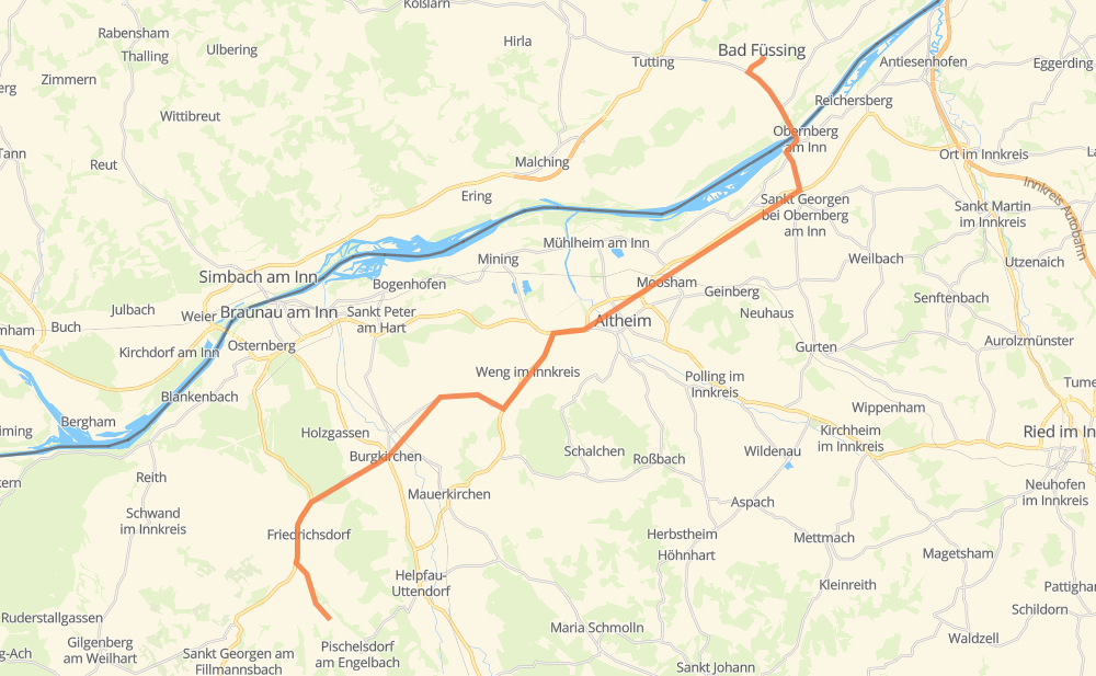
The distance from Ottendorf to Bad Füssing is 40 kilometers by road. Road takes approximately 32 minutes and goes through Altheim, Schützing, Dietzing, Neukirchen an der Enknach, Sankt Georgen, Vorbuch and Dietraching.
| Shortest distance by air | 29 km ✈️ |
| Car route length | 40 km 🚗 |
| Driving time | 32 min |
| Fuel amount | 3.2 L |
| Fuel cost | 5.7 AUD |
| Point | Distance | Time | Fuel | |
| Ottendorf | 0 km | 00 min | 0.0 L | |
|
L1025 2 km, 02 min
|
||||
| Schützing | 2 km | 02 min | 0.1 L | |
|
L1025 B156 3 km, 02 min
|
||||
| Neukirchen an der Enknach | 5 km | 04 min | 0.3 L | |
|
B156 L1053 6 km, 04 min
|
||||
| Sankt Georgen | 11 km | 09 min | 0.8 L | |
|
L1056 2 km, 01 min
|
||||
| Vorbuch | 13 km | 10 min | 0.9 L | |
|
L1056 3 km, 02 min
|
||||
| Dietraching | 16 km | 12 min | 1.2 L | |
|
L1056 B142 3 km, 02 min
|
||||
| Bergham | 18 km | 15 min | 1.4 L | |
|
B142 B148 5 km, 03 min
|
||||
| Altheim | 24 km | 18 min | 1.7 L | |
|
B148 11 km, 08 min
|
||||
| Obernberg am Inn | 35 km | 27 min | 2.8 L | |
|
L510 St 2117 5 km, 04 min
|
||||
| Bad Füssing | 40 km | 31 min | 2.9 L | |
Hotels of Bad Füssing
Frequently Asked Questions
How much does it cost to drive from Ottendorf to Bad Füssing?
Fuel cost: 5.7 AUD
This fuel cost is calculated as: (Route length 40 km / 100 km) * (Fuel consumption 8 L/100 km) * (Fuel price 1.8 AUD / L)
You can adjust fuel consumption and fuel price here.
How long is a car ride from Ottendorf to Bad Füssing?
Driving time: 32 min
This time is calculated for driving at the maximum permitted speed, taking into account traffic rules restrictions.
- 26 km with a maximum speed 90 km/h = 17 min
- 4 km with a maximum speed 80 km/h = 2 min
- 2 km with a maximum speed 70 km/h = 2 min
- 6 km with a maximum speed 50 km/h = 7 min
- 1 km with a maximum speed 30 km/h = 2 min
The calculated driving time does not take into account intermediate stops and traffic jams.
How far is Ottendorf to Bad Füssing by land?
The distance between Ottendorf and Bad Füssing is 40 km by road.
Precise satellite coordinates of highways were used for this calculation. The start and finish points are the centers of Ottendorf and Bad Füssing respectively.
What city is halfway between Ottendorf and Bad Füssing?
The halfway point between Ottendorf and Bad Füssing is Bergham. It is located about 1 km from the exact midpoint by road.
The distance from Bergham to Ottendorf is 18 km and driving will take about 15 min. The road between Bergham and Bad Füssing has length 21 km and will take approximately 17 min.
The other cities located close to halfway point:
Where is Ottendorf in relation to Bad Füssing?
Ottendorf is located 29 km south-west of Bad Füssing.
Ottendorf has geographic coordinates: latitude 48.14212, longitude 13.06812.
Bad Füssing has geographic coordinates: latitude 48.35067, longitude 13.30954.