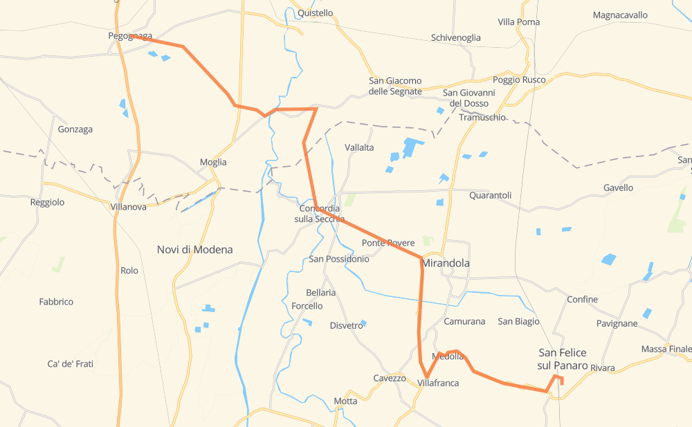
Distance between Pegognaga and San Felice sul Panaro
The distance from Pegognaga to San Felice sul Panaro is 41 kilometers by road. Road takes approximately 36 minutes and goes through Mirandola, Santa Caterina, Ponte Rovere, Villafranca and Medolla.
| Shortest distance by air | 29 km ✈️ |
| Car route length | 41 km 🚗 |
| Driving time | 36 min |
| Fuel amount | 3.3 L |
| Fuel cost | 5.9 AUD |
| Point | Distance | Time | Fuel | |
| Pegognaga | 0 km | 00 min | 0.0 L | |
|
SP49 3 km, 02 min
|
||||
| Vo' Giorgi | 3 km | 02 min | 0.2 L | |
|
SP44 3 km, 03 min
|
||||
| Coazze | 6 km | 06 min | 0.3 L | |
|
SP44 3 km, 03 min
|
||||
| Bondanello | 9 km | 09 min | 0.6 L | |
|
SP51 SP44 8 km, 08 min
|
||||
| Santa Caterina | 17 km | 18 min | 1.3 L | |
|
SP8 6 km, 04 min
|
||||
| Ponte Rovere | 23 km | 22 min | 1.8 L | |
|
SP8 4 km, 02 min
|
||||
| Mirandola | 26 km | 25 min | 1.8 L | |
|
SS12 4 km, 03 min
|
||||
| Villafranca | 30 km | 28 min | 2.4 L | |
|
SS12 2 km, 01 min
|
||||
| Medolla | 32 km | 29 min | 2.5 L | |
|
SS12 SP468R 9 km, 07 min
|
||||
| San Felice sul Panaro | 41 km | 36 min | 2.8 L | |
Hotels of San Felice sul Panaro
Frequently Asked Questions
How much does it cost to drive from Pegognaga to San Felice sul Panaro?
Fuel cost: 5.9 AUD
This fuel cost is calculated as: (Route length 41 km / 100 km) * (Fuel consumption 8 L/100 km) * (Fuel price 1.8 AUD / L)
You can adjust fuel consumption and fuel price here.
How long is a car ride from Pegognaga to San Felice sul Panaro?
Driving time: 36 min
This time is calculated for driving at the maximum permitted speed, taking into account traffic rules restrictions.
- 6 km with a maximum speed 90 km/h = 4 min
- 19 km with a maximum speed 80 km/h = 14 min
- 14 km with a maximum speed 50 km/h = 17 min
The calculated driving time does not take into account intermediate stops and traffic jams.
How far is Pegognaga to San Felice sul Panaro by land?
The distance between Pegognaga and San Felice sul Panaro is 41 km by road.
Precise satellite coordinates of highways were used for this calculation. The start and finish points are the centers of Pegognaga and San Felice sul Panaro respectively.
What city is halfway between Pegognaga and San Felice sul Panaro?
The halfway point between Pegognaga and San Felice sul Panaro is Ponte Rovere. It is located about 2 km from the exact midpoint by road.
The distance from Ponte Rovere to Pegognaga is 23 km and driving will take about 22 min. The road between Ponte Rovere and San Felice sul Panaro has length 18 km and will take approximately 14 min.
The other cities located close to halfway point:
Where is Pegognaga in relation to San Felice sul Panaro?
Pegognaga is located 29 km north-west of San Felice sul Panaro.
Pegognaga has geographic coordinates: latitude 44.99599, longitude 10.85877.
San Felice sul Panaro has geographic coordinates: latitude 44.83317, longitude 11.1426.