Distance between Peixe and Bacuri
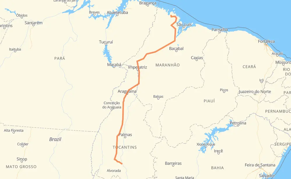
The distance from Peixe to Bacuri is 1,627 kilometers by road. Road takes approximately 19 hours and 4 minutes and goes through Açailândia, Santana, Serrano II and Estreito.
| Shortest distance by air | 1,206 km ✈️ |
| Car route length | 1,627 km 🚗 |
| Driving time | 19 h 4 min |
| Fuel amount | 130.2 L |
| Fuel cost | 231.7 AUD |
| Point | Distance | Time | Fuel | |
| -12.03910, -48.53925 | 0 km | 00 min | 0.0 L | |
|
BR-153 234 km, 2 h 37 min
|
||||
| Santana | 234 km | 2 h 37 min | 35.7 L | |
|
BR-153 17 km, 12 min
|
||||
| Serrano II | 251 km | 2 h 49 min | 37.8 L | |
|
BR-153 390 km, 4 h 21 min
|
||||
| Ponta do Asfalto | 641 km | 7 h 10 min | 67.9 L | |
|
BR-153 BR-226 91 km, 1 h 04 min
|
||||
| Estreito | 732 km | 8 h 15 min | 75.9 L | |
|
BR-226 BR-010 89 km, 59 min
|
||||
| Ribeirãozinho da Roça | 820 km | 9 h 14 min | 83.1 L | |
|
BR-010 15 km, 11 min
|
||||
| Bananal_ | 835 km | 9 h 26 min | 83.8 L | |
|
BR-010 29 km, 20 min
|
||||
| Vila São João | 864 km | 9 h 46 min | 86.7 L | |
|
BR-010 51 km, 37 min
|
||||
| Açailândia | 915 km | 10 h 24 min | 90.0 L | |
|
BR-010 14 km, 10 min
|
||||
| Novo Horizonte | 929 km | 10 h 34 min | 92.1 L | |
|
BR-222 38 km, 28 min
|
||||
| Jardim Bela Vista | 968 km | 11 h 03 min | 92.8 L | |
|
BR-222 659 km, 8 h 01 min
|
||||
| -1.72908, -45.14057 | 1,627 km | 19 h 04 min | 148.0 L | |
Frequently Asked Questions
How much does it cost to drive from Peixe to Bacuri?
Fuel cost: 231.7 AUD
This fuel cost is calculated as: (Route length 1,627 km / 100 km) * (Fuel consumption 8 L/100 km) * (Fuel price 1.78 AUD / L)
You can adjust fuel consumption and fuel price here.
How long is a car ride from Peixe to Bacuri?
Driving time: 19 h 4 min
This time is calculated for driving at the maximum permitted speed, taking into account traffic rules restrictions.
- 932 km with a maximum speed 90 km/h = 10 h 21 min
- 688 km with a maximum speed 80 km/h = 8 h 36 min
- 6 km with a maximum speed 60 km/h = 5 min
- 1 km with a maximum speed 40 km/h = 1 min
The calculated driving time does not take into account intermediate stops and traffic jams.
How far is Peixe to Bacuri by land?
The distance between Peixe and Bacuri is 1,627 km by road.
Precise satellite coordinates of highways were used for this calculation. The start and finish points are the centers of Peixe and Bacuri respectively.
How far is Peixe to Bacuri by plane?
The shortest distance (air line, as the crow flies) between Peixe and Bacuri is 1,206 km.
This distance is calculated using the Haversine formula as a great-circle distance between two points on the surface of a sphere. The start and finish points are the centers of Peixe and Bacuri respectively. Actual distance between airports may be different.
How many hours is Peixe from Bacuri by plane?
Boeing 737 airliner needs 1 h 30 min to cover the distance of 1,206 km at a cruising speed of 800 km/h.
Small plane "Cessna 172" needs 5 h 28 min to flight this distance at average speed of 220 km/h.
This time is approximate and do not take into account takeoff and landing times, airport location and other real world factors.
How long is a helicopter ride from Peixe to Bacuri?
Fast helicopter "Eurocopter AS350" or "Hughes OH-6 Cayuse" need 5 h 1 min to cover the distance of 1,206 km at a cruising speed of 240 km/h.
Popular "Robinson R44" needs 5 h 44 min to flight this distance at average speed of 210 km/h.
This time is approximate and do not take into account takeoff and landing times, aerodrome location and other real world factors.
What city is halfway between Peixe and Bacuri?
The halfway point between Peixe and Bacuri is Ribeirãozinho da Roça. It is located about 7 km from the exact midpoint by road.
The distance from Ribeirãozinho da Roça to Peixe is 820 km and driving will take about 9 h 14 min. The road between Ribeirãozinho da Roça and Bacuri has length 807 km and will take approximately 9 h 49 min.
The other cities located close to halfway point:
Where is Peixe in relation to Bacuri?
Peixe is located 1,206 km south-west of Bacuri.
Peixe has geographic coordinates: latitude -12.0391, longitude -48.53925.
Bacuri has geographic coordinates: latitude -1.72908, longitude -45.14057.
Which highway goes from Peixe to Bacuri?
The route from Peixe to Bacuri follows BR-153, BR-222, BR-010, MA-014.
Other minor sections pass along the road:
- BR-226: 99 km
- TO-373: 70 km
- MA-006: 66 km
- MA-303: 47 km
- MA-006 / BR-308: 31 km
- MA-106: 12 km
- BR-316: 10 km
- BR-230: 2 km