Distance between Pelican Rapids MB and Meaford ON
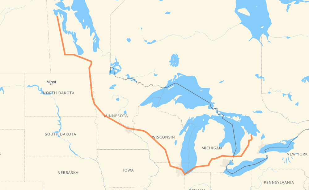
The distance from Pelican Rapids to Meaford is 2,831 kilometers by road including 1,903 kilometers on motorways. Road takes approximately 29 hours and 27 minutes and goes through Portage la Prairie, Winnipeg, Grand Forks, Fargo, Eau Claire, Madison and Janesville.
| Shortest distance by air | 1,722 km ✈️ |
| Car route length | 2,831 km 🚗 |
| Driving time | 29 h 27 min |
| Fuel amount | 226.5 L |
| Fuel cost | 407.7 AUD |
| Point | Distance | Time | Fuel | |
| Pelican Rapids | 0 km | 00 min | 0.0 L | |
|
PTH 10 515 km, 6 h 01 min
|
||||
| Portage la Prairie | 515 km | 6 h 01 min | 40.6 L | |
|
PTH 1 85 km, 58 min
|
||||
| Winnipeg | 600 km | 6 h 59 min | 46.8 L | |
|
PTH 100 I 29 228 km, 2 h 34 min
|
||||
| Grand Forks | 828 km | 9 h 34 min | 65.7 L | |
|
I 29 119 km, 1 h 17 min
|
||||
| Fargo | 947 km | 10 h 52 min | 75.0 L | |
|
I 29 I 94 526 km, 5 h 02 min
|
||||
| Eau Claire | 1,473 km | 15 h 54 min | 116.9 L | |
|
I 94 282 km, 2 h 34 min
|
||||
| Madison | 1,755 km | 18 h 29 min | 139.7 L | |
|
I 39 56 km, 30 min
|
||||
| Janesville | 1,811 km | 18 h 59 min | 144.5 L | |
|
I 39 I 90 173 km, 1 h 39 min
|
||||
| Chicago | 1,985 km | 20 h 38 min | 156.9 L | |
|
I 90 I 94 231 km, 2 h 12 min
|
||||
| Kalamazoo | 2,216 km | 22 h 51 min | 177.1 L | |
|
I 94 I 69 104 km, 56 min
|
||||
| Lansing | 2,320 km | 23 h 47 min | 185.5 L | |
|
I 69 99 km, 54 min
|
||||
| Flint | 2,419 km | 24 h 42 min | 193.1 L | |
|
I 69 122 km, 1 h 14 min
|
||||
| Sarnia | 2,541 km | 25 h 56 min | 202.6 L | |
|
402 23 290 km, 3 h 29 min
|
||||
| Meaford | 2,831 km | 29 h 26 min | 226.2 L | |
Hotels of Meaford
Frequently Asked Questions
How much does it cost to drive from Pelican Rapids to Meaford?
Fuel cost: 407.7 AUD
This fuel cost is calculated as: (Route length 2,831 km / 100 km) * (Fuel consumption 8 L/100 km) * (Fuel price 1.8 AUD / L)
You can adjust fuel consumption and fuel price here.
How long is a car ride from Pelican Rapids to Meaford?
Driving time: 29 h 27 min
This time is calculated for driving at the maximum permitted speed, taking into account traffic rules restrictions.
- 1,299 km with a maximum speed 110 km/h = 11 h 48 min
- 28 km with a maximum speed 105 km/h = 15 min
- 334 km with a maximum speed 100 km/h = 3 h 20 min
- 33 km with a maximum speed 97 km/h = 20 min
- 530 km with a maximum speed 90 km/h = 5 h 53 min
- 40 km with a maximum speed 89 km/h = 27 min
- 514 km with a maximum speed 80 km/h = 6 h 25 min
- 13 km with a maximum speed 72 km/h = 10 min
- 9 km with a maximum speed 70 km/h = 7 min
- 9 km with a maximum speed 60 km/h = 9 min
- 1 km with a maximum speed 56 km/h = 1 min
- 20 km with a maximum speed 50 km/h = 24 min
- 2 km with a maximum speed 40 km/h = 2 min
The calculated driving time does not take into account intermediate stops and traffic jams.
How far is Pelican Rapids to Meaford by land?
The distance between Pelican Rapids and Meaford is 2,831 km by road including 1,903 km on motorways.
Precise satellite coordinates of highways were used for this calculation. The start and finish points are the centers of Pelican Rapids and Meaford respectively.
How far is Pelican Rapids to Meaford by plane?
The shortest distance (air line, as the crow flies) between Pelican Rapids and Meaford is 1,722 km.
This distance is calculated using the Haversine formula as a great-circle distance between two points on the surface of a sphere. The start and finish points are the centers of Pelican Rapids and Meaford respectively. Actual distance between airports may be different.
How many hours is Pelican Rapids from Meaford by plane?
Boeing 737 airliner needs 2 h 9 min to cover the distance of 1,722 km at a cruising speed of 800 km/h.
Small plane "Cessna 172" needs 7 h 49 min to flight this distance at average speed of 220 km/h.
This time is approximate and do not take into account takeoff and landing times, airport location and other real world factors.
How long is a helicopter ride from Pelican Rapids to Meaford?
Fast helicopter "Eurocopter AS350" or "Hughes OH-6 Cayuse" need 7 h 10 min to cover the distance of 1,722 km at a cruising speed of 240 km/h.
Popular "Robinson R44" needs 8 h 11 min to flight this distance at average speed of 210 km/h.
This time is approximate and do not take into account takeoff and landing times, aerodrome location and other real world factors.
What city is halfway between Pelican Rapids and Meaford?
The halfway point between Pelican Rapids and Meaford is Menomonie. It is located about 28 km from the exact midpoint by road.
The distance from Menomonie to Pelican Rapids is 1,443 km and driving will take about 15 h 37 min. The road between Menomonie and Meaford has length 1,388 km and will take approximately 13 h 49 min.
The other cities located close to halfway point:
Where is Pelican Rapids in relation to Meaford?
Pelican Rapids is located 1,722 km north-west of Meaford.
Pelican Rapids has geographic coordinates: latitude 52.73973, longitude -100.6891.
Meaford has geographic coordinates: latitude 44.60866, longitude -80.59146.
Which highway goes from Pelican Rapids to Meaford?
The route from Pelican Rapids to Meaford follows I 94, I 90, PTH 10, I 69, I 29, US 81, I 39, PTH 16.
Other minor sections pass along the road:
- 23: 96 km
- PTH 75: 93 km
- PTH 1: 85 km
- 402: 63 km
- I 694: 46 km
- PR 268: 45 km
- US 51: 32 km
- PTH 5: 25 km
- PTH 100: 23 km
- CR 7: 23 km
- 6: 22 km
- 4: 19 km
- US 59: 17 km
- 7: 16 km
- 19: 15 km
- 89: 14 km
- CR 13: 12 km
- CR 4: 9 km
- I 96: 7 km
- US 10: 7 km
- MN 95: 6 km
- US 12: 6 km
- 81: 5 km
- MN 210: 5 km
- US 52: 5 km
- US 31: 5 km
- WI 35: 4 km
- WI 11: 3 km
- Route 42: 2 km
- 26: 1 km
- CR 86: 1 km