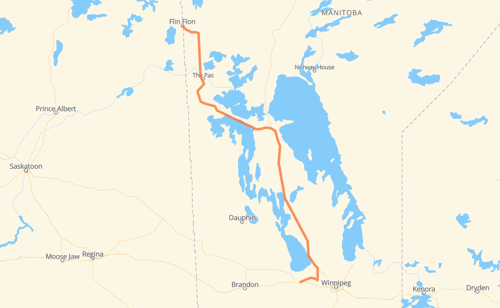
Distance between Portage la Prairie MB and Flin Flon MB
The distance from Portage la Prairie to Flin Flon is 771 kilometers by road. Road takes approximately 8 hours and 47 minutes and goes through Saint-Laurent, Oak Point, Eriksdale, Mulvihill, Moosehorn, Hilbre and Fairford.
| Shortest distance by air | 586 km ✈️ |
| Car route length | 771 km 🚗 |
| Driving time | 8 h 47 min |
| Fuel amount | 61.7 L |
| Fuel cost | 111 AUD |
| Point | Distance | Time | Fuel | |
| Portage la Prairie | 0 km | 00 min | 0.0 L | |
|
PTH 1A PTH 26 105 km, 1 h 13 min
|
||||
| Saint-Laurent | 105 km | 1 h 13 min | 5.8 L | |
|
PTH 6 44 km, 32 min
|
||||
| Eriksdale | 149 km | 1 h 45 min | 11.0 L | |
|
PTH 6 15 km, 11 min
|
||||
| Mulvihill | 164 km | 1 h 56 min | 12.9 L | |
|
PTH 6 44 km, 30 min
|
||||
| Moosehorn | 208 km | 2 h 26 min | 15.9 L | |
|
PTH 6 26 km, 18 min
|
||||
| Hilbre | 234 km | 2 h 45 min | 17.8 L | |
|
PTH 6 15 km, 11 min
|
||||
| Fairford | 248 km | 2 h 56 min | 19.6 L | |
|
PTH 6 373 km, 4 h 08 min
|
||||
| Young Point | 621 km | 7 h 05 min | 49.6 L | |
|
PTH 10 8 km, 05 min
|
||||
| The Pas | 629 km | 7 h 11 min | 49.8 L | |
|
PTH 10 142 km, 1 h 36 min
|
||||
| Flin Flon | 771 km | 8 h 47 min | 61.4 L | |
Hotels of Flin Flon
Frequently Asked Questions
How much does it cost to drive from Portage la Prairie to Flin Flon?
Fuel cost: 111 AUD
This fuel cost is calculated as: (Route length 771 km / 100 km) * (Fuel consumption 8 L/100 km) * (Fuel price 1.8 AUD / L)
You can adjust fuel consumption and fuel price here.
How long is a car ride from Portage la Prairie to Flin Flon?
Driving time: 8 h 47 min
This time is calculated for driving at the maximum permitted speed, taking into account traffic rules restrictions.
- 610 km with a maximum speed 90 km/h = 6 h 46 min
- 161 km with a maximum speed 80 km/h = 2 h
The calculated driving time does not take into account intermediate stops and traffic jams.
How far is Portage la Prairie to Flin Flon by land?
The distance between Portage la Prairie and Flin Flon is 771 km by road.
Precise satellite coordinates of highways were used for this calculation. The start and finish points are the centers of Portage la Prairie and Flin Flon respectively.
How far is Portage la Prairie to Flin Flon by plane?
The shortest distance (air line, as the crow flies) between Portage la Prairie and Flin Flon is 586 km.
This distance is calculated using the Haversine formula as a great-circle distance between two points on the surface of a sphere. The start and finish points are the centers of Portage la Prairie and Flin Flon respectively. Actual distance between airports may be different.
How many hours is Portage la Prairie from Flin Flon by plane?
Boeing 737 airliner needs 43 min to cover the distance of 586 km at a cruising speed of 800 km/h.
Small plane "Cessna 172" needs 2 h 39 min to flight this distance at average speed of 220 km/h.
This time is approximate and do not take into account takeoff and landing times, airport location and other real world factors.
How long is a helicopter ride from Portage la Prairie to Flin Flon?
Fast helicopter "Eurocopter AS350" or "Hughes OH-6 Cayuse" need 2 h 26 min to cover the distance of 586 km at a cruising speed of 240 km/h.
Popular "Robinson R44" needs 2 h 47 min to flight this distance at average speed of 210 km/h.
This time is approximate and do not take into account takeoff and landing times, aerodrome location and other real world factors.
Where is Portage la Prairie in relation to Flin Flon?
Portage la Prairie is located 586 km south-east of Flin Flon.
Portage la Prairie has geographic coordinates: latitude 49.97242, longitude -98.28919.
Flin Flon has geographic coordinates: latitude 54.7698, longitude -101.87897.
Which highway goes from Portage la Prairie to Flin Flon?
The route from Portage la Prairie to Flin Flon follows PTH 6, PTH 10, PTH 60.
Other minor sections pass along the road:
- PTH 26: 40 km
- PR 248: 28 km
- PTH 68: 11 km
- PTH 1A: 4 km
- PTH 10A: 3 km
- PR 325: 2 km