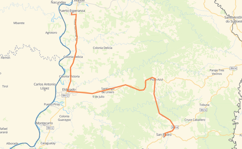
Distance between Puerto Esperanza and San Pedro
The distance from Puerto Esperanza to San Pedro is 148 kilometers by road. Road takes approximately 1 hour and 53 minutes and goes through Eldorado, Colonia Delicia, Pozo Azul, Comunidad Aborigen Aguai Poty, Paraje Perejhá Guazú, Nueve de Julio Kilómetro 20 and Comunidad Aborigen Santiago de Liniers.
| Shortest distance by air | 84 km ✈️ |
| Car route length | 148 km 🚗 |
| Driving time | 1 h 53 min |
| Fuel amount | 11.8 L |
| Fuel cost | 21.4 AUD |
| Point | Distance | Time | Fuel | |
| Puerto Esperanza | 0 km | 00 min | 0.0 L | |
|
RN12 24 km, 17 min
|
||||
| Comunidad Aborigen Aguai Poty | 24 km | 17 min | 1.8 L | |
|
RN12 5 km, 03 min
|
||||
| Colonia Delicia | 28 km | 21 min | 2.0 L | |
|
RN12 5 km, 04 min
|
||||
| Paraje Perejhá Guazú | 34 km | 25 min | 2.6 L | |
|
RN12 15 km, 11 min
|
||||
| Eldorado | 49 km | 37 min | 3.4 L | |
|
RP17 22 km, 16 min
|
||||
| Nueve de Julio Kilómetro 20 | 71 km | 53 min | 4.4 L | |
|
RP17 31 km, 23 min
|
||||
| Pozo Azul | 102 km | 1 h 16 min | 6.8 L | |
|
RP17 RP20 28 km, 21 min
|
||||
| Gramado | 130 km | 1 h 38 min | 9.5 L | |
|
RP20 14 km, 11 min
|
||||
| Paraje Palmera Boca | 144 km | 1 h 49 min | 11.4 L | |
|
RN14 4 km, 03 min
|
||||
| San Pedro | 148 km | 1 h 53 min | 11.7 L | |
Frequently Asked Questions
How much does it cost to drive from Puerto Esperanza to San Pedro?
Fuel cost: 21.4 AUD
This fuel cost is calculated as: (Route length 148 km / 100 km) * (Fuel consumption 8 L/100 km) * (Fuel price 1.81 AUD / L)
You can adjust fuel consumption and fuel price here.
How long is a car ride from Puerto Esperanza to San Pedro?
Driving time: 1 h 53 min
This time is calculated for driving at the maximum permitted speed, taking into account traffic rules restrictions.
- 25 km with a maximum speed 90 km/h = 16 min
- 109 km with a maximum speed 80 km/h = 1 h 21 min
- 12 km with a maximum speed 60 km/h = 12 min
- 1 km with a maximum speed 40 km/h = 1 min
- 1 km with a maximum speed 30 km/h = 1 min
The calculated driving time does not take into account intermediate stops and traffic jams.
How far is Puerto Esperanza to San Pedro by land?
The distance between Puerto Esperanza and San Pedro is 148 km by road.
Precise satellite coordinates of highways were used for this calculation. The start and finish points are the centers of Puerto Esperanza and San Pedro respectively.
How far is Puerto Esperanza to San Pedro by plane?
The shortest distance (air line, as the crow flies) between Puerto Esperanza and San Pedro is 84 km.
This distance is calculated using the Haversine formula as a great-circle distance between two points on the surface of a sphere. The start and finish points are the centers of Puerto Esperanza and San Pedro respectively. Actual distance between airports may be different.
How many hours is Puerto Esperanza from San Pedro by plane?
Boeing 737 airliner needs 6 min to cover the distance of 84 km at a cruising speed of 800 km/h.
Small plane "Cessna 172" needs 22 min to flight this distance at average speed of 220 km/h.
This time is approximate and do not take into account takeoff and landing times, airport location and other real world factors.
How long is a helicopter ride from Puerto Esperanza to San Pedro?
Fast helicopter "Eurocopter AS350" or "Hughes OH-6 Cayuse" need 21 min to cover the distance of 84 km at a cruising speed of 240 km/h.
Popular "Robinson R44" needs 24 min to flight this distance at average speed of 210 km/h.
This time is approximate and do not take into account takeoff and landing times, aerodrome location and other real world factors.
What city is halfway between Puerto Esperanza and San Pedro?
The halfway point between Puerto Esperanza and San Pedro is Nueve de Julio Kilómetro 20. It is located about 3 km from the exact midpoint by road.
The distance from Nueve de Julio Kilómetro 20 to Puerto Esperanza is 71 km and driving will take about 53 min. The road between Nueve de Julio Kilómetro 20 and San Pedro has length 77 km and will take approximately 1 h.
Where is Puerto Esperanza in relation to San Pedro?
Puerto Esperanza is located 84 km north-west of San Pedro.
Puerto Esperanza has geographic coordinates: latitude -26.02051, longitude -54.61003.
San Pedro has geographic coordinates: latitude -26.62405, longitude -54.11115.
Which highway goes from Puerto Esperanza to San Pedro?
The route from Puerto Esperanza to San Pedro follows RP17.
Other minor sections pass along the road:
- RN12: 43 km
- RP20: 33 km
- RN14: 7 km