Distance between Queen Creek AZ and Cortena CA
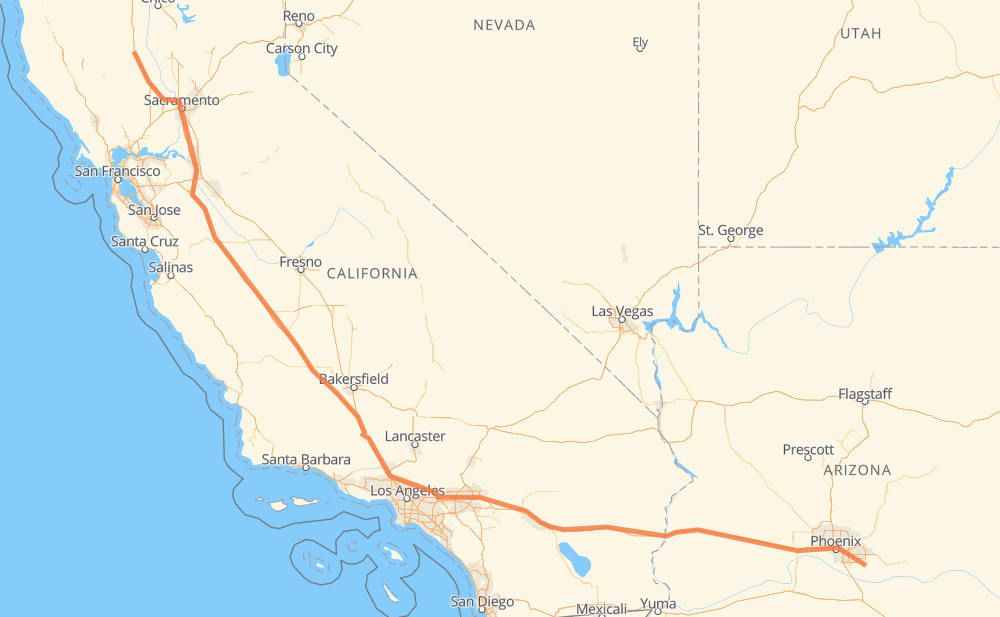
The distance from Queen Creek to Cortena is 1,375 kilometers by road including 1,359 kilometers on motorways. Road takes approximately 12 hours and 50 minutes and goes through Phoenix, Tolleson, Indio, Palm Springs, Calimesa, Redlands and San Bernardino.
| Shortest distance by air | 1,155 km ✈️ |
| Car route length | 1,375 km 🚗 |
| Driving time | 12 h 50 min |
| Fuel amount | 110 L |
| Fuel cost | 196.9 AUD |
| Point | Distance | Time | Fuel | |
| Queen Creek | 0 km | 00 min | 0.0 L | |
|
US 60 63 km, 38 min
|
||||
| Phoenix | 63 km | 38 min | 3.8 L | |
|
I 10 16 km, 09 min
|
||||
| Tolleson | 79 km | 48 min | 6.2 L | |
|
I 10 384 km, 3 h 31 min
|
||||
| Indio | 464 km | 4 h 19 min | 36.1 L | |
|
I 10 82 km, 44 min
|
||||
| Calimesa | 545 km | 5 h 03 min | 43.4 L | |
|
I 10 11 km, 06 min
|
||||
| Redlands | 556 km | 5 h 09 min | 43.9 L | |
|
I 10 11 km, 06 min
|
||||
| San Bernardino | 567 km | 5 h 15 min | 45.2 L | |
|
I 10 11 km, 06 min
|
||||
| Rialto | 578 km | 5 h 22 min | 46.1 L | |
|
I 10 7 km, 04 min
|
||||
| Fontana | 585 km | 5 h 26 min | 46.4 L | |
|
I 10 13 km, 07 min
|
||||
| Ontario | 598 km | 5 h 33 min | 47.2 L | |
|
I 10 15 km, 08 min
|
||||
| Pomona | 613 km | 5 h 42 min | 48.7 L | |
|
I 10 CA 57 19 km, 11 min
|
||||
| Azusa | 632 km | 5 h 53 min | 50.3 L | |
|
I 210 9 km, 05 min
|
||||
| Monrovia | 641 km | 5 h 58 min | 51.2 L | |
|
I 210 4 km, 02 min
|
||||
| Arcadia | 645 km | 6 h 00 min | 51.4 L | |
|
I 210 9 km, 05 min
|
||||
| Pasadena | 654 km | 6 h 06 min | 51.8 L | |
|
I 210 9 km, 05 min
|
||||
| La Cañada Flintridge | 663 km | 6 h 11 min | 52.9 L | |
|
I 210 6 km, 03 min
|
||||
| Glendale | 670 km | 6 h 14 min | 53.5 L | |
|
I 210 15 km, 08 min
|
||||
| Los Angeles | 684 km | 6 h 23 min | 53.6 L | |
|
I 210 I 5 24 km, 14 min
|
||||
| Santa Clarita | 709 km | 6 h 37 min | 56.1 L | |
|
I 5 493 km, 4 h 31 min
|
||||
| Stockton | 1,201 km | 11 h 08 min | 95.3 L | |
|
I 5 70 km, 39 min
|
||||
| Sacramento | 1,272 km | 11 h 47 min | 100.5 L | |
|
I 5 104 km, 1 h 02 min
|
||||
| Cortena | 1,375 km | 12 h 49 min | 109.5 L | |
Frequently Asked Questions
How much does it cost to drive from Queen Creek to Cortena?
Fuel cost: 196.9 AUD
This fuel cost is calculated as: (Route length 1,375 km / 100 km) * (Fuel consumption 8 L/100 km) * (Fuel price 1.79 AUD / L)
You can adjust fuel consumption and fuel price here.
How long is a car ride from Queen Creek to Cortena?
Driving time: 12 h 50 min
This time is calculated for driving at the maximum permitted speed, taking into account traffic rules restrictions.
- 959 km with a maximum speed 110 km/h = 8 h 43 min
- 379 km with a maximum speed 105 km/h = 3 h 37 min
- 7 km with a maximum speed 100 km/h = 4 min
- 8 km with a maximum speed 89 km/h = 5 min
- 4 km with a maximum speed 80 km/h = 3 min
- 8 km with a maximum speed 80 km/h = 6 min
- 7 km with a maximum speed 50 km/h = 8 min
The calculated driving time does not take into account intermediate stops and traffic jams.
How far is Queen Creek to Cortena by land?
The distance between Queen Creek and Cortena is 1,375 km by road including 1,359 km on motorways.
Precise satellite coordinates of highways were used for this calculation. The start and finish points are the centers of Queen Creek and Cortena respectively.
How far is Queen Creek to Cortena by plane?
The shortest distance (air line, as the crow flies) between Queen Creek and Cortena is 1,155 km.
This distance is calculated using the Haversine formula as a great-circle distance between two points on the surface of a sphere. The start and finish points are the centers of Queen Creek and Cortena respectively. Actual distance between airports may be different.
How many hours is Queen Creek from Cortena by plane?
Boeing 737 airliner needs 1 h 26 min to cover the distance of 1,155 km at a cruising speed of 800 km/h.
Small plane "Cessna 172" needs 5 h 15 min to flight this distance at average speed of 220 km/h.
This time is approximate and do not take into account takeoff and landing times, airport location and other real world factors.
How long is a helicopter ride from Queen Creek to Cortena?
Fast helicopter "Eurocopter AS350" or "Hughes OH-6 Cayuse" need 4 h 48 min to cover the distance of 1,155 km at a cruising speed of 240 km/h.
Popular "Robinson R44" needs 5 h 30 min to flight this distance at average speed of 210 km/h.
This time is approximate and do not take into account takeoff and landing times, aerodrome location and other real world factors.
What city is halfway between Queen Creek and Cortena?
The halfway point between Queen Creek and Cortena is Los Angeles. It is located about 3 km from the exact midpoint by road.
The distance from Los Angeles to Queen Creek is 684 km and driving will take about 6 h 23 min. The road between Los Angeles and Cortena has length 691 km and will take approximately 6 h 27 min.
The other cities located close to halfway point:
Where is Queen Creek in relation to Cortena?
Queen Creek is located 1,155 km south-east of Cortena.
Queen Creek has geographic coordinates: latitude 33.24839, longitude -111.63416.
Cortena has geographic coordinates: latitude 39.21906, longitude -122.18609.
Which highway goes from Queen Creek to Cortena?
The route from Queen Creek to Cortena follows I 5, I 10.
Other minor sections pass along the road:
- I 210: 71 km
- US 60: 37 km
- US 95: 31 km
- CA 33: 19 km
- CA 57: 7 km
- I 5 BUS: 6 km
- AZ 202 Loop: 4 km
- I 5 Truck: 4 km
- CA 126: 2 km
- I-10: 1 km
- AZ 24: 1 km