Distance between Rio Veloso and São Rafael
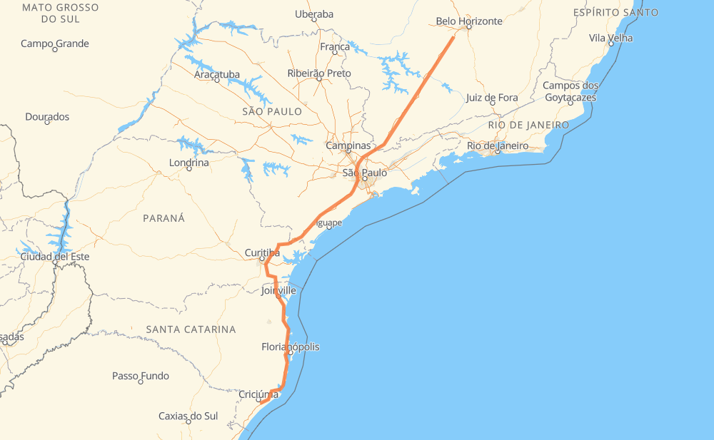
The distance from Rio Veloso to São Rafael is 1,387 kilometers by road including 1,356 kilometers on motorways. Road takes approximately 14 hours and 46 minutes and goes through Atibaia, Barueri, Piraquara, Itaguara, Carmópolis de Minas, Santo Antônio do Amparo and Perdões.
| Shortest distance by air | 1,081 km ✈️ |
| Car route length | 1,387 km 🚗 |
| Driving time | 14 h 46 min |
| Fuel amount | 111 L |
| Fuel cost | 199.8 AUD |
| Point | Distance | Time | Fuel | |
| Rio Veloso | 0 km | 00 min | 0.0 L | |
|
BR-381 32 km, 21 min
|
||||
| Itaguara | 32 km | 21 min | 1.8 L | |
|
BR-381 28 km, 17 min
|
||||
| Carmópolis de Minas | 60 km | 39 min | 4.5 L | |
|
BR-381 61 km, 37 min
|
||||
| Santo Antônio do Amparo | 121 km | 1 h 16 min | 9.3 L | |
|
BR-381 30 km, 16 min
|
||||
| Perdões | 151 km | 1 h 33 min | 11.6 L | |
|
BR-381 44 km, 23 min
|
||||
| Carmo da Cachoeira | 194 km | 1 h 57 min | 15.2 L | |
|
BR-381 264 km, 2 h 33 min
|
||||
| Atibaia | 459 km | 4 h 31 min | 35.6 L | |
|
SP-065 SP-354 74 km, 51 min
|
||||
| Barueri | 533 km | 5 h 22 min | 42.3 L | |
|
SP-021 BR-116 395 km, 4 h 29 min
|
||||
| Piraquara | 928 km | 9 h 52 min | 73.6 L | |
|
BR-116 BR-101 474 km, 4 h 54 min
|
||||
| São Rafael | 1,401 km | 14 h 46 min | 111.9 L | |
Frequently Asked Questions
How much does it cost to drive from Rio Veloso to São Rafael?
Fuel cost: 199.8 AUD
This fuel cost is calculated as: (Route length 1,387 km / 100 km) * (Fuel consumption 8 L/100 km) * (Fuel price 1.8 AUD / L)
You can adjust fuel consumption and fuel price here.
How long is a car ride from Rio Veloso to São Rafael?
Driving time: 14 h 46 min
This time is calculated for driving at the maximum permitted speed, taking into account traffic rules restrictions.
- 672 km with a maximum speed 110 km/h = 6 h 6 min
- 395 km with a maximum speed 100 km/h = 3 h 57 min
- 55 km with a maximum speed 90 km/h = 36 min
- 148 km with a maximum speed 80 km/h = 1 h 51 min
- 120 km with a maximum speed 60 km/h = 2 h
- 9 km with a maximum speed 40 km/h = 13 min
The calculated driving time does not take into account intermediate stops and traffic jams.
How far is Rio Veloso to São Rafael by land?
The distance between Rio Veloso and São Rafael is 1,387 km by road including 1,356 km on motorways.
Precise satellite coordinates of highways were used for this calculation. The start and finish points are the centers of Rio Veloso and São Rafael respectively.
How far is Rio Veloso to São Rafael by plane?
The shortest distance (air line, as the crow flies) between Rio Veloso and São Rafael is 1,081 km.
This distance is calculated using the Haversine formula as a great-circle distance between two points on the surface of a sphere. The start and finish points are the centers of Rio Veloso and São Rafael respectively. Actual distance between airports may be different.
How many hours is Rio Veloso from São Rafael by plane?
Boeing 737 airliner needs 1 h 21 min to cover the distance of 1,081 km at a cruising speed of 800 km/h.
Small plane "Cessna 172" needs 4 h 54 min to flight this distance at average speed of 220 km/h.
This time is approximate and do not take into account takeoff and landing times, airport location and other real world factors.
How long is a helicopter ride from Rio Veloso to São Rafael?
Fast helicopter "Eurocopter AS350" or "Hughes OH-6 Cayuse" need 4 h 30 min to cover the distance of 1,081 km at a cruising speed of 240 km/h.
Popular "Robinson R44" needs 5 h 8 min to flight this distance at average speed of 210 km/h.
This time is approximate and do not take into account takeoff and landing times, aerodrome location and other real world factors.
What city is halfway between Rio Veloso and São Rafael?
The halfway point between Rio Veloso and São Rafael is Jacupiranga. It is located about 44 km from the exact midpoint by road.
The distance from Jacupiranga to Rio Veloso is 737 km and driving will take about 7 h 28 min. The road between Jacupiranga and São Rafael has length 650 km and will take approximately 7 h 18 min.
The other cities located close to halfway point:
Where is Rio Veloso in relation to São Rafael?
Rio Veloso is located 1,081 km north-east of São Rafael.
Rio Veloso has geographic coordinates: latitude -20.15952, longitude -44.33737.
São Rafael has geographic coordinates: latitude -28.75553, longitude -49.329.
Which highway goes from Rio Veloso to São Rafael?
The route from Rio Veloso to São Rafael follows BR-381, BR-116, BR-101, SP-230.
Other minor sections pass along the road:
- BR-376: 74 km
- BR-478: 49 km
- SP-354: 40 km
- SP-010: 36 km
- SP-021: 22 km
- SP-330: 15 km
- BR-050: 15 km
- SP-065: 12 km
- BR-277: 9 km
- JAR-354: 9 km
- BR-494: 3 km