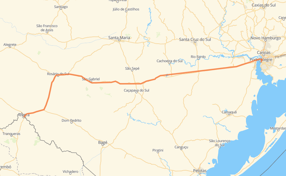
Distance between Rivera and Porto Alegre
The distance from Rivera to Porto Alegre is 495 kilometers by road including 16 kilometers on motorways. Road takes approximately 6 hours and 1 minute and goes through Carajá, Vila Prates, Santo Antônio, Vila Motta and Industrial.
| Shortest distance by air | 424 km ✈️ |
| Car route length | 495 km 🚗 |
| Driving time | 6 h 1 min |
| Fuel amount | 39.6 L |
| Fuel cost | 71.3 AUD |
| Point | Distance | Time | Fuel | |
| Rivera | 0 km | 00 min | 0.0 L | |
|
BR-158 10 km, 09 min
|
||||
| Carajá | 10 km | 09 min | 0.7 L | |
|
BR-158 98 km, 1 h 10 min
|
||||
| Vila Prates | 108 km | 1 h 20 min | 8.6 L | |
|
BR-290 182 km, 2 h 07 min
|
||||
| Acampamento Indígena | 290 km | 3 h 27 min | 23.0 L | |
|
BR-153 BR-290 120 km, 1 h 27 min
|
||||
| Santo Antônio | 410 km | 4 h 55 min | 32.6 L | |
|
BR-290 3 km, 02 min
|
||||
| Vila Motta | 412 km | 4 h 57 min | 33.0 L | |
|
BR-290 37 km, 27 min
|
||||
| Assentamento São Pedro | 449 km | 5 h 24 min | 35.7 L | |
|
BR-290 29 km, 21 min
|
||||
| Industrial | 478 km | 5 h 46 min | 38.1 L | |
|
BR-290 BR-116 19 km, 14 min
|
||||
| Porto Alegre | 497 km | 6 h 00 min | 39.6 L | |
Frequently Asked Questions
How much does it cost to drive from Rivera to Porto Alegre?
Fuel cost: 71.3 AUD
This fuel cost is calculated as: (Route length 495 km / 100 km) * (Fuel consumption 8 L/100 km) * (Fuel price 1.8 AUD / L)
You can adjust fuel consumption and fuel price here.
How long is a car ride from Rivera to Porto Alegre?
Driving time: 6 h 1 min
This time is calculated for driving at the maximum permitted speed, taking into account traffic rules restrictions.
- 14 km with a maximum speed 100 km/h = 8 min
- 202 km with a maximum speed 90 km/h = 2 h 14 min
- 264 km with a maximum speed 80 km/h = 3 h 18 min
- 9 km with a maximum speed 60 km/h = 8 min
- 6 km with a maximum speed 50 km/h = 7 min
- 1 km with a maximum speed 40 km/h = 2 min
- 1 km with a maximum speed 30 km/h = 1 min
The calculated driving time does not take into account intermediate stops and traffic jams.
How far is Rivera to Porto Alegre by land?
The distance between Rivera and Porto Alegre is 495 km by road including 16 km on motorways.
Precise satellite coordinates of highways were used for this calculation. The start and finish points are the centers of Rivera and Porto Alegre respectively.
How far is Rivera to Porto Alegre by plane?
The shortest distance (air line, as the crow flies) between Rivera and Porto Alegre is 424 km.
This distance is calculated using the Haversine formula as a great-circle distance between two points on the surface of a sphere. The start and finish points are the centers of Rivera and Porto Alegre respectively. Actual distance between airports may be different.
How many hours is Rivera from Porto Alegre by plane?
Boeing 737 airliner needs 31 min to cover the distance of 424 km at a cruising speed of 800 km/h.
Small plane "Cessna 172" needs 1 h 55 min to flight this distance at average speed of 220 km/h.
This time is approximate and do not take into account takeoff and landing times, airport location and other real world factors.
How long is a helicopter ride from Rivera to Porto Alegre?
Fast helicopter "Eurocopter AS350" or "Hughes OH-6 Cayuse" need 1 h 46 min to cover the distance of 424 km at a cruising speed of 240 km/h.
Popular "Robinson R44" needs 2 h 1 min to flight this distance at average speed of 210 km/h.
This time is approximate and do not take into account takeoff and landing times, aerodrome location and other real world factors.
What city is halfway between Rivera and Porto Alegre?
The halfway point between Rivera and Porto Alegre is Acampamento Indígena. It is located about 42 km from the exact midpoint by road.
The distance from Acampamento Indígena to Rivera is 290 km and driving will take about 3 h 27 min. The road between Acampamento Indígena and Porto Alegre has length 205 km and will take approximately 2 h 33 min.
Where is Rivera in relation to Porto Alegre?
Rivera is located 424 km west of Porto Alegre.
Rivera has geographic coordinates: latitude -30.90006, longitude -55.54082.
Porto Alegre has geographic coordinates: latitude -30.0325, longitude -51.23038.
Which highway goes from Rivera to Porto Alegre?
The route from Rivera to Porto Alegre follows BR-290, BR-158.
Other minor sections pass along the road:
- BR-153: 55 km
- BR-293: 31 km
- BR-116: 15 km
- Rs-290: 9 km
- BR-473: 5 km