Distance between Rivière-Salée and Lamentin
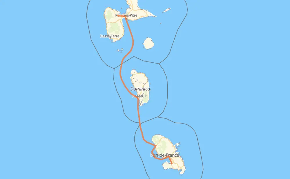
The distance from Rivière-Salée to Lamentin is 261 kilometers by road including 8 kilometers on motorways. Road takes approximately 11 hours and 48 minutes and goes through Fort-de-France, Résidence Carrière, Ducos, Le Lamentin, Pointe-à-Pitre, Les Abymes and Baie-Mahault.
| Shortest distance by air | 206 km ✈️ |
| Car route length | 261 km 🚗 |
| Driving time | 11 h 48 min |
| Fuel amount | 20.9 L |
| Fuel cost | 37.8 AUD |
| Point | Distance | Time | Fuel | |
| Rivière-Salée | 0 km | 00 min | 0.0 L | |
|
N 5 6 km, 04 min
|
||||
| Ducos | 6 km | 04 min | 0.2 L | |
|
N 5 7 km, 05 min
|
||||
| Le Lamentin | 13 km | 09 min | 0.7 L | |
|
A 1 6 km, 04 min
|
||||
| Fort-de-France | 19 km | 14 min | 1.4 L | |
|
N 1 229 km, 11 h 23 min
|
||||
| Pointe-à-Pitre | 248 km | 11 h 37 min | 19.7 L | |
|
D 125 2 km, 02 min
|
||||
| Les Abymes | 249 km | 11 h 39 min | 19.9 L | |
|
D 126 6 km, 03 min
|
||||
| Baie-Mahault | 255 km | 11 h 43 min | 20.0 L | |
|
N 2 6 km, 04 min
|
||||
| Lamentin | 261 km | 11 h 48 min | 20.8 L | |
Frequently Asked Questions
How much does it cost to drive from Rivière-Salée to Lamentin?
Fuel cost: 37.8 AUD
This fuel cost is calculated as: (Route length 261 km / 100 km) * (Fuel consumption 8 L/100 km) * (Fuel price 1.81 AUD / L)
You can adjust fuel consumption and fuel price here.
How long is a car ride from Rivière-Salée to Lamentin?
Driving time: 11 h 48 min
This time is calculated for driving at the maximum permitted speed, taking into account traffic rules restrictions.
- 15 km with a maximum speed 90 km/h = 10 min
- 10 km with a maximum speed 80 km/h = 7 min
- 7 km with a maximum speed 70 km/h = 5 min
- 1 km with a maximum speed 50 km/h = 1 min
- 228 km with a maximum speed 20 km/h = 11 h 23 min
The calculated driving time does not take into account intermediate stops and traffic jams.
How far is Rivière-Salée to Lamentin by land?
The distance between Rivière-Salée and Lamentin is 261 km by road including 8 km on motorways.
Precise satellite coordinates of highways were used for this calculation. The start and finish points are the centers of Rivière-Salée and Lamentin respectively.
How far is Rivière-Salée to Lamentin by plane?
The shortest distance (air line, as the crow flies) between Rivière-Salée and Lamentin is 206 km.
This distance is calculated using the Haversine formula as a great-circle distance between two points on the surface of a sphere. The start and finish points are the centers of Rivière-Salée and Lamentin respectively. Actual distance between airports may be different.
How many hours is Rivière-Salée from Lamentin by plane?
Boeing 737 airliner needs 15 min to cover the distance of 206 km at a cruising speed of 800 km/h.
Small plane "Cessna 172" needs 56 min to flight this distance at average speed of 220 km/h.
This time is approximate and do not take into account takeoff and landing times, airport location and other real world factors.
How long is a helicopter ride from Rivière-Salée to Lamentin?
Fast helicopter "Eurocopter AS350" or "Hughes OH-6 Cayuse" need 51 min to cover the distance of 206 km at a cruising speed of 240 km/h.
Popular "Robinson R44" needs 58 min to flight this distance at average speed of 210 km/h.
This time is approximate and do not take into account takeoff and landing times, aerodrome location and other real world factors.
Where is Rivière-Salée in relation to Lamentin?
Rivière-Salée is located 206 km south-east of Lamentin.
Rivière-Salée has geographic coordinates: latitude 14.52767, longitude -60.97879.
Lamentin has geographic coordinates: latitude 16.27034, longitude -61.6303.